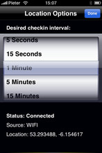
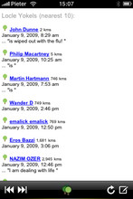
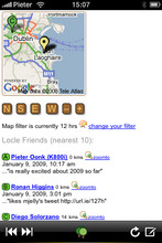
Locle is a mobile application that lets users see where their friends and family are without the need for GPS. Wherever you are, always find out where people are and meet them for lunch, drinks or whatever you want to do. Just make sure you don't miss out on anything.
Like it? Share with your friends!
If you got an error while installing Themes, Software or Games, please, read FAQ.
Supported operating systems:
Google Android 1.0, Google Android 1.5, Google Android 1.6, Google Android 10.x, Google Android 2.0, Google Android 2.1, Google Android 2.2, Google Android 2.3, Google Android 3.0, Google Android 3.1, Google Android 3.2, Google Android 4.0, Google Android 4.1, Google Android 4.2, Google Android 4.3, Google Android 4.4, Google Android 5.x, Google Android 6.x, Google Android 7.x, Google Android 8.x, Google Android 9.x, Java ME, Java Nokia 240x320, Java SE 240x320, Palm OS 3.x, Palm OS 4.x, Palm OS 5.x, Pocket PC 2002, RIM BlackBerry OS 4.0, RIM BlackBerry OS 4.1, RIM BlackBerry OS 4.2, RIM BlackBerry OS 4.3, RIM BlackBerry OS 4.5, RIM BlackBerry OS 4.6, RIM BlackBerry OS 4.7, RIM BlackBerry OS 5.0, RIM BlackBerry OS 6.0, Windows Mobile 2003, Windows Mobile 5.0, Windows Mobile 6 Classic, Windows Mobile 6 Professional, Windows Mobile 6.1 Classic, Windows Mobile 6.1 Professional, Windows Mobile 6.5 Professional
Similar Software:
yozi yozi is a navigation software for the Android platform. It uses digital topographic maps in well-known Ozi Explorer formats for navigation and doesn't require network access like built-in Maps application on Android
Locus - addon AR This is BETA version of simple addon for Locus mapping application (version 1.1.0 and higher). Allow to show actual POI's visible on map, in Augmented reality view. In Locus Free, usage is limited to 1 minute. This addon do not have any screen or widget
Vespucci OpenStreetMap Editor Vespucci is the first editor for OpenStreetMap on Android. You can download the map data for a specific area and edit the map. After editing, you can send it directly to the OSM Server.
What's New in This Release:
New features:
· OpenStreetBugs support(disabled by default)
· layers incl
HERE WeGo - Offline maps & GPS HERE WeGo - will always help you find the needed way in the city. The application will offer the best routes for any mode of transport or for going on foot. This utility will take you to the destination point with the help of voice messages and will inform you about extra ways in case of change on the road
Map Explorer Map Explorer is a prototype that tries to improve map browsing experience. It is basically Google maps with an overlay that shows POIs even if they are beyond the display. Use the preferences to test different visualizations
Maps on free Maps on free - navigation maps which can be used in offline mode. All you need to do is to download the information to the memory card of your device. You can add files with ready routes and marked orienting points. You don't have to worry about constant Internet connection anymore while travelling
NAVIGON MobileNavigator NAVIGON MobileNavigator - Turn your Android phone into a mobile navigation device with lots of useful functions that will delight you! The pocket navigation device will show you the right way with functions such as Reality View Pro and Lane Assistant Pro
GoPenS GoPenS is an OpenSource GPS application for Android phones, based on OpenStreetMap (OSM). OpenStreetMap is a collaborative map of the world. Therefore, one of the main functions of the application is to be able to record a trace and send it as a GPX to the OSM servers, and so edit the OSM Map
Sensorly Map Viewer Sensorly Map Viewer - How good is your cell/mobile network coverage where you need it?
Is your favorite WiFi network going to be available at your vacation spot?
See the answer with this application and join us to build worldwide coverage maps.
(Data collection is configurable and can be turned off
OSMTracker for Android OSMTracker stands for OpenStreetMap Tracker. It allows you to track your journey and mark significant way points. Way points can be marked with a tag using a button, with a quick voice record, a text note or by taking a picture. The various button pages and layouts can be customized to suit your OpenStreetMap activities
Other Software by developer «Leprecian»:
not found
Comments on Locle:
Comments not found
If you noted an error or download link is broken, please, report it via this page or use comments.
Locle is compatible with your device OnePlus X Dual SIM LTE NA