US Terrain Intelligence for Android - The Outdoor Navigation software is your best friend through your adventures in the wild.
Go into the outdoors with confidence and enjoy your activities without worrying about the tools to help you navigate. Your Outdoor Navigation app is made by the people who have been developing this software since 2003 across multiple platforms. Be sure that you will stay ahead of the rest with continuous updates and relevant tools.
It is an excellent tool for biking, jogging, skiing, hiking, geocaching, boating, flying and many other sporting activities.
United States Terrain Intelligence will give you access to the most sophisticated Ground Guidance technology and allow you to take advantage of services that have only been available to military personal until now.
Terrain Intelligence takes into account a multitude of variables, including elevation, land cover and aerial aspects to calculate the best possible route.
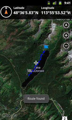
To plan your your off road activities:
· Select Terrain Intelligence as Routing Type in Options
· Route Settings
· Tap on the map to select start and end off road points
· Route will be calculated using Terrain Intelligence service
This plugin works only in the USA.
Installation instructions:
Outdoor US Terrain Intelligence is an add-on for the free Outdoor Navigation application. You need to have your Outdoor Navigation installed to be able to use Outdoor US Terrain Intelligence.
Download and install Outdoor US Terrain Intelligence on your Android device. Start the Outdoor US Terrain Intelligence plugin to complete the license checking: when activation will be completed then the icon will be removed (you need to restart your device to hide the icon) and the plugin will be used inside Outdoor Navigation application
What's New in This Release:
· Bug fixing
Like it? Share with your friends!
Supported operating systems:
Google Android 10.x, Google Android 2.1, Google Android 2.2, Google Android 2.3, Google Android 3.0, Google Android 3.1, Google Android 3.2, Google Android 4.0, Google Android 4.1, Google Android 4.2, Google Android 4.3, Google Android 4.4, Google Android 5.x, Google Android 6.x, Google Android 7.x, Google Android 8.x, Google Android 9.x
Similar Software:
India Festival 2011 India Festival 2011 - Festivals of India - Complete Information on more than 90 Festivals & Fairs celebrated all across India. Send E-cards, greetings, get to know each festival very closely
The Most Beautiful Bays The Most Beautiful Bays - The Bay of Roses has joined the Most Beautiful Bays in the World Club, a distinction which carries with it the endorsement of UNESCO
World Explorer World Explorer - This game uses Google Maps allowing you to travel around our beautiful world to discover lots of wonderful landmarks and countries!
The objective is to find out which landmark/country you are visiting at the moment.
To make things easier, you may ask for hints, move the map, zoom in/out and change between satellite and map mode
Adventure Activities Adventure Activities - Bestowed with towering peaks and mountains, fascinating rivers, challenging terrains and other natural marvels, India has become an epitome of adventure sports in the world. Be it on the east, west, north or south, the country has ample of options that offer the desired adrenaline kicks to the adventure junkies
Top American Roadside Attractions Top American Roadside Attractions - What better way to celebrate summer than by taking a road trip? Nestled between Niagara Falls, Mount Rushmore, Alcatraz Island and dozens of other destinations are these nostalgic, gaudy, run-down and kitschy locations. TIME takes a look (in alphabetical order) at of the greatest. Take a tour of the best roadside kitsch in the U.S
Elevation Profile Elevation Profile - This application shows the elevation profile of the path.
Create the path by tapping the map. Different modes of path creating are available: direct, driving, walking and bicycling. Direct mode draws straight lines between points. Driving, walking and bicycling modes are able to find and follow roads between points
All-Star Locations App All-Star Locations App - All-Star Locations is a full service location scouting & managing company catering to the Film, TV, Video, Catalog & Fashion Industry. With this convenient app, you can access our library (registration req.), connect with us, like us on Facebook, even post to our social wall, all from the comfort of your smartphone or tablet
Cape Adieu Darwin Cape Adieu Darwin - Welcome aboard the Cape Adieu Relax and enjoy a magnificent Darwin sunset indulge in a chef prepared locally caught seafood & BBQ banquet BYO & licenced Be our guest aboard the Cape Adieu whilst cruising Darwin Harbour
LivingSocial LivingSocial - The best daily deals in your city from LivingSocial.
LivingSocial helps you discover the best of your city even when you’re on the go. We have the inside scoop on the best shopping, restaurants, activities and more—all handpicked, unique, and an incredible value
Rio Carnival Photos Get in the mood for the biggest party in the world - The Carnaval in Rio de Janeiro - with this picture gallery. Rio Carnival is as considered the biggest carnival in the world and as locals describe it "the greatest show on Earth"
Other Software by developer «GPS Tuner»:
Outdoor SOS for Android Outdoor SOS for Android - The Outdoor Navigation software is your best friend through your adventures in the wild.
Go into the outdoors with confidence and enjoy your activities without worrying about the tools to help you navigate. Your Outdoor Navigation app is made by the people who have been developing this software since 2003 across multiple platforms
GPS Tuner Essentials Full Version with BENELUX Basic Map Content GPS Tuner Essentials Full Version with BENELUX Basic Map Content is designed specifically for off-road use: its large buttons, selectable tool window size, multiple Compass views and the built-in Tele Atlas map makes it extremely user-friendly and reliable
GPS Tuner Atlas Full Version with Full Europe Basic Map Content GPS Tuner Atlas Full Version with Full Europe Basic Map Content is designed specifically for off-road use: its large buttons, selectable tool window size, 6 different types of Compass views and the built-in Tele Atlas map makes it extremely user-friendly and reliable
GPS Tuner Essentials GPS Tuner Essentials is designed specifically for off-road use: its large buttons, selectable tool window size, multiple Compass views make it extremely user-friendly and reliable
GPS Tuner Essentials Full Version with Iberia Basic Map Content GPS Tuner Essentials Full Version with Iberia Basic Map Content is designed specifically for off-road use: its large buttons, selectable tool window size, multiple Compass views and the built-in Tele Atlas map makes it extremely user-friendly and reliable
GPS Tuner Essentials Full Version with British Isles Basic Map Content GPS Tuner Essentials Full Version with British Isles Basic Map Content is designed specifically for off-road use: its large buttons, selectable tool window size, multiple Compass views and the built-in Tele Atlas map makes it extremely user-friendly and reliable
Outdoor Chart for Android Outdoor Chart for Android - The Outdoor Navigation software is your best friend through your adventures in the wild.
Go into the outdoors with confidence and enjoy your activities without worrying about the tools to help you navigate. Your Outdoor Navigation app is made by the people who have been developing this software since 2003 across multiple platforms
Outdoor Offline Maps for Android Outdoor Offline Maps for Android - The Outdoor Navigation software is your best friend through your adventures in the wild.
Go into the outdoors with confidence and enjoy your activities without worrying about the tools to help you navigate. Your Outdoor Navigation app is made by the people who have been developing this software since 2003 across multiple platforms
GPS Tuner Atlas Full Version with Asia Pacific Basic Map Content GPS Tuner Atlas Full Version with Asia Pacific Basic Map Content is designed specifically for off-road use: its large buttons, selectable tool window size, multiple Compass views and the built-in Tele Atlas map makes it extremely user-friendly and reliable