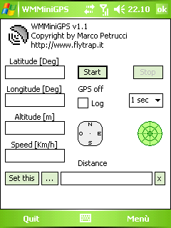
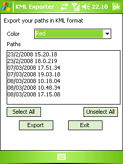
WMMiniGPSis a Windows Mobile 5/6 software which gets your GPS data in a really simple gui, showing you latitude, longitude, altitude and speed. It can log all to file and it can export your paths to Google Earth's kml and gpx format.
There's a compass, which shows your direction and you can set latitude and longitude of a point and the program will show you the way to reach it with a radar, telling you how many meters / kilometers there are to cover.
What's New in This Release:
· fixed export dialog box problem
Like it? Share with your friends!
If you got an error while installing Themes, Software or Games, please, read FAQ.
Supported operating systems:
Windows Mobile 5.0, Windows Mobile 6 Classic, Windows Mobile 6 Professional, Windows Mobile 6.1 Classic
Similar Software:
Gippos Gippos is an application for mobile devices allowing the user to locate his or her position on the map, share the location with friends and see other users on the same map. Users can also exchange instant messages with their friends
Satsports Log Satsports Log is your general sport app. Ideal for running, cycling, mountain biking, hiking and walking. It also has some fun visual features such as maps and graphs of your elevation, speed and pace. Real time Statistics: Satsports-log has all the stats you could wish
ExercisesGPSs ExercisesGPSs - ExercisesGPSs uses the GPS on your PocketPC to measure your speed/walking/running speed. The program displays your speed in Km/h with 3-digit accuracy. NOTE: Use caution when exercising and using this program.
This program requires that you have both the 'BeanDLL.dll' file ** and ** the runtime files for Visual Basic on your PocketPC computer
FamilyUpdateds FamilyUpdateds - FamilyUpdateds can be used to get updates from family members using the PocketPC FamilyUpdaterer. You can group the URLs from each person into family groups. Tap on the name to view the current update.
This program requires that you have both the 'BeanDLL.dll' file ** and ** the runtime files for Visual Basic on your PocketPC computer
Movmap GPS Tracker Movmap GPS Trackeris a simple freeware GPS tracking program meant for WinCE/PocketPC machines. It can run on PNAs that use WinCE 4.2 .NET Core OS. See the movmap.txt file for details. Source codes for the program are also available
HandGPS HandGPS is provided for use with Windows PPC only. All versions of windows PPC are supported. Users are prompted to register product before use. License is valid for two years and may be extended. HandGPS is used to capture GPS coordinates to any open windows PPC application
GPSLocaterer GPSLocaterer uses the GPS on your PocketPC to find your current latitude/longitude/speed and altitude and allows you to view your position on a map from the Google.com maps service. You can customize the maps zoom, and type via the 'Options' in the toolbar
iPlotter A comprehensive maritime passage planning and chart plotter navigation aid for Windows Mobile
Other Software by developer «Marco Petrucci»:
not found
Comments on WMMiniGPS:
Comments not found
If you noted an error or download link is broken, please, report it via this page or use comments.
WMMiniGPS is compatible with your device Orange SPV M700