BRDMap - Interactive map of Germany with informations about the German states and their capitals.
English and German version included.
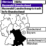
· Graphic selection State - Tapping a federal country in the map: Land is marked and the name of the Federal Lands and the state capital appears.
· Selection of the Federal Lands on list - Federal land is marked on the map and the name of the respective country's capital is shown.
· Selection of the state capital on list - The corresponding federal land is marked on the map and the name of the Federal Lands appears.
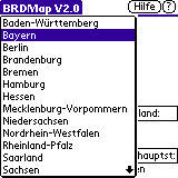
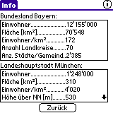
· Display of statistical data for a federal state and its capital city.
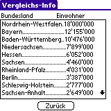
· For every individual statistical value - comparative representation of all Provinces and State capitals.
What's New in This Release:
· Soft-reset on Palm T | X fixed
Like it? Share with your friends!
Supported operating systems:
Palm OS 4.x, Palm OS 5.x
Similar Software:
Mobile25 Mobile25 is a mapping application. It was meant to be used on our geocaching trips. The maps are stored as compressed bitmaps on memory card and e.g. the 1:100.000 (TOP100) and 1:25.000 (TOP25) maps of Baden-Wurttemberg, Germany together require about 700MB of memory card space.
Mobile25 supports bluetooth GPS devices and can display the current GPS position on the map
Earth&Sun Earth&Sun - It also displays:
- The latitude and longitude of an Earth location.
- The time zone at that location, based on only longitude not civil boundaries.
- The current time at that location based on the above time zone.
- The sunrise and sunset times, and day length at that location.
- Distance between two locations on the earth surface
MetrO Metro helps you find your way in the public transport systems (subway, bus, trams, ...) in more than 4000 cities around the world. FREE, FAST & ACCURATE. Simply enter you start and end stops, hit the "Go" button and the program finds the fastest route
(i)_World Pro Edition (i)_World Pro Edition - The most Complete and Interactive World Atlas.
Whatever you are a globe-trotter, VIP, student, ... , (i)_World allows you to have at the end of your stylus the most complete socio-economic database of 219 countries and 25 seas or oceans of our planet. (i)_World features more than 7000 informations
MetrO (PPC) Metro helps you find your way in the public transport systems (subway, bus, trams, ...) in more than 4000 cities around the world. FREE, FAST & ACCURATE. Simply enter you start and end stops, hit the "Go" button and the program finds the fastest route
Travel Berlin (Palm OS) Travel Berlin (Palm OS) is a comprehensive travel guide and phrasebook illustrated with maps and photographs
Locle Locle is a mobile application that lets users see where their friends and family are without the need for GPS. Wherever you are, always find out where people are and meet them for lunch, drinks or whatever you want to do. Just make sure you don't miss out on anything
Mapopolis Enhanced Map Pack Mapopolis Enhanced Map Pack - A one year Map Pack to the Mapopolis Enhanced map library entitles you to download any U.S. map(s) from the map data release that is current at the time of your purchase for one year. Once downloaded, maps continue working forever. Mapopolis makes viewing maps on your Palm OS handheld easy and fun
Europe Elevation Maps Europe Elevation Maps - This free pack contains high resolution elevation map for Europe, divided into 2 smaller pieces. Each tile covers the projected area of 40°x50°, and contains almost 29 million of samples (one sample per square kilometer).
51 countries lie in the area covered by this pack
Other Software by developer «Ulrich Riepert»:
SimCalc SimCalc - Statistics calculator for the process or material flow simulation.
# Calculate the relationship between availability, MTTR (mean time to repair) and MTBF (mean distance interference).
# The calculated parameters of the gamma function to MTBF and MTTR in a random distribution to be displayed.
# Stores 5 independent scenarios
PercentCalc PercentCalc - Percentage calculator:
# Percentage Increase
Returns to Formula
A + X% = B (or A-X% = B)
The third value when the other two values are known.
# Relationship Equation
Returns to Formula
A: 100% = B: X%.
The third value when the other two values are known


_World Pro Edition")
")

")


