Supported operating systems:
Windows Mobile 5.0, Windows Mobile 6 Classic, Windows Mobile 6 Professional, Windows Mobile 6.1 Classic, Windows Mobile 6.1 Professional
Similar Software:
WinMoSquare You can check-in to different venues, follow your friends, add new venues and much more !
GPS2Watch GPS2Watch - Add-on for smartWatchM that displays GPS information on supported Bluetooth watches. It simply uses smartWatchM "3rd party notifications", and connects to WM5+'s intermediate GPS driver, so no messing with COM ports. It should work with any device/GPS combination, if the GPS is external it must be set in WM's "External GPS" settings
MapZIPed MapZIPed allows you to enter a US ZIP code and searches the USZIP.com website for the GPS information and places it into a downloadable map. You can also view the location on the Google.com maps service. This service is provided by USZIP
MusicGoogler MusicGoogler uses the GPS on your PocketPC to find the 50 closest Music CD and Instrument stores sorted via GPS distance. Tap the button to start the GPS and when you get a lock tap on it to view the list of local stores. You can also dial the store. The GPS maps and store search service is provided by Google
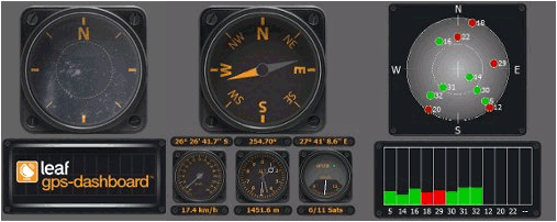
SirfGPSTweaker SirfGPSTweaker - application for displaying output from NMEA or SIRFBINARY based GPS device.
It has autodetection of data format (so it works both in NMEA or SIRF with on the fly detection). It can display statistics and data panel for cockpit use. Cockpit mode includes history graphs for speed and altitude
TextMapperer TextMapperer - TextMapperer allows you to create named text based GPS maps. When you get a GPS lock then you can create a new map and enter text for the area. When you save the text the map is downloaded and the text and GPS is appended to the end of the map with current GPS
BlueWave GPS Displays GPS navigational information for boating
FileGPSes FileGPSes - FileGPSes allows you to browse and execute the GPS tagged files and view them sorted in distance from your current GPS. You can also view and download the files placed on a Google.com map. This program uses "The Vincenty inverse formula for ellipsoids." (accuracy to within 0.5mm, or 0
PoliceSpeeders PoliceSpeeders - PoliceSpeeders can be used by a police officer for an informal police speed trap. Enter the distance between the two points in settings and metric/imperial and tap the button or joypad when a car hits the start line and then again at the end line. The program calculates the estimated speeds into a log file
Terracrosser Terracrosser is a free GPS navigation software for Windows Mobile Pocket PC.
· Terracrosser works in Map and Photo modes
· Terracrosser uses zoomable maps
· Terracrosser is completely compatible with Google Maps service. With included Mapper module you can download maps from the Internet
Comments on GPS Dashboard:
Comments not found
If you noted an error or download link is broken, please, report it via this page or use comments.
GPS Dashboard is compatible with your device Palm Treo 750/750v