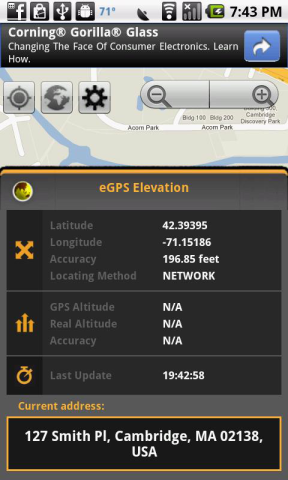
eGPS Elevation has greatly improved altitude and elevation readings. In a typical Android GPS, altitude readings are notoriously inaccurate. eGPS Elevation will even show how deep is the nearest water area.
!!!Works with GPS feature turned off!!!
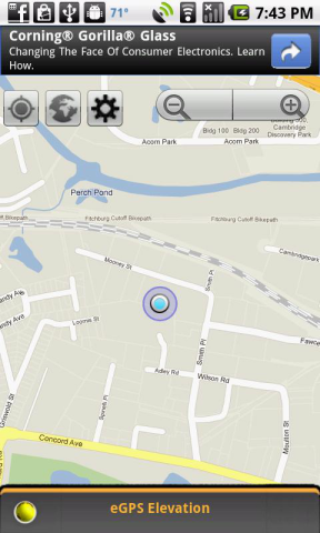
eGPS Elevation will come in handy for any fan of outdoor activities such as hiking, cycling, camping or any location-based social networking activities. It also uses the most advanced map technology to give you precise directions and pinpoint your destination address down to the zip code. Anyone who has ever found themselves on a road trip in an unfamiliar city will be able to appreciate the ability to receive such accurate directions whenever they want to find a restaurant, gas station or hotel.
eGPS Elevation app is sure to please fans of our eGPS Lite. Like the eGPS Lite, this app has all the GPS capabilities you could ask for and shows your destination or location down to the latitude and longitude, speed and heading.
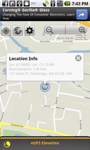
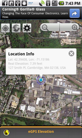
The biggest difference between this app and the eGPS Lite is that this app has greatly improved altitude and elevation readings. In a typical Android GPS, altitude readings are notoriously inaccurate. People don't always think about things such as altitude and elevation when they are deciding on where they want to go when they travel, but it is a bigger factor that many realize. High altitude can have an effect on a person's health if he isn't used to it. The thinner air can result in issues such as shallower breathing, insomnia and decreased appetite. These are by no means severe, but they can be bothersome. Knowing a location's real altitude and real elevation can indeed come in handy, and with this app you can be sure that your GPS altitude and GPS elevation will be far more accurate than what can be found on any other Android GPS app on the market. Just touch any part of the map screen on the app's easy-to-read interface to know the exact altitude and elevation of that location.
Like it? Share with your friends!
Supported operating systems:
Google Android 1.0, Google Android 1.5, Google Android 1.6, Google Android 10.x, Google Android 2.0, Google Android 2.1, Google Android 2.2, Google Android 2.3, Google Android 3.0, Google Android 3.1, Google Android 3.2, Google Android 4.0, Google Android 4.1, Google Android 4.2, Google Android 4.3, Google Android 4.4, Google Android 5.x, Google Android 6.x, Google Android 7.x, Google Android 8.x, Google Android 9.x
Similar Software:
Super Swiss Army Knife Free Super Swiss Army Knife Free - This is a super software which has a multi-functional combination applying to life, travel and military combat. It is a veritable Swiss Army Knife with a cool widget desktop, including eight functions of ruler, protractor, flashlight, compass, gradienter, vertical, wall picture, telemeasurement
GeoLog GeoLog saves the sensors data (gps, accelerometer, magnetometer data, etc.) of your device to a log file and calculates the coverage of the site. The coverage is a ratio of the track covering area to the area of the site (expressed in percents)
Epic Compass Epic Compass - When you are a traveler or lost in somewhere place, you must need a compass. Caompass can be used in outdoor and many activities you can do such as hiking, climbing, flying etc
Android-Speedometer Android-Speedometer - Simple speedometer application and widget for Android.
Tip: on small screens hide timer or compass in settings.
Android-Speedometer features:
· numeric values for: speed (km/h, mph or kn), altitude (from GPS or webservice), cyclometer (km, mi, nm), timer, digital clock, compass, max
My Sensors Ad For those Android smart-phones that have various sensors built-in, this app attempt to access and retrieve values for display. Three common sensors are shown. Light, Temperature, 3-axis Magnetic field
SpeedView An advanced speedometer application that offers lots of useful features.SpeedView uses the phone's built-in GPS system to show your current, maximum and average speed, as well as direction, total distance and time traveled. Suitable for running, car driving, biking or hiking
Compass3D Compass3D - This augmented reality application adds a 3D compass to the live camera view in real-time.
What's New in This Release:
· Support APP2SD
What's New in 4.0:
· minor fix
What's New in 3.7:
· code optimization
What's New in 3.7:
· minor bugfixes
What's New in 3
Travel Compass In addition to basic compass function, also match a map fixed position, more easily provide the regions in all countries urgent telephone by the revolving of map to the purpose headway, ensure a self security
Point Where Ad This app does not aim to replace a compass. What it does is to serve a simple need using the accelerator and magnetic sensors in Android phone to point direction. For some people, you need to know the direction of a place/city reference to your own location
Kompas Kompas is a small pocket tool for compass navigation
Other Software by developer «Exetik Systems, LLC»:
eGPS Lite eGPS Lite has full GPS capabilities, showing latitude and longitude, altitude, speed, and heading. This makes it useful for all kinds of activities where you would usually want a GPS device - hiking, cycling, geocaching and letterboxing, running, location-based social networking activities, and more