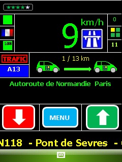
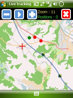
Mobbyway - Based on both internet mobile technologies and GPS, Mobbyway allows you to know easily, at any time, your relatives’ exact position on a map if they have accepted it and if they are connected to the network.
Mobbyway is also a help on the road network with a local alert system of a dangerous zone which is carried out with the network of members. Finally, Mobbyway will reference all the fixed radars in the countries where it is used and Mobbyway will indicate them to you.
Mobbyway was developed to allow:
- you to stay connected with your relatives wherever they are.
- your relatives to follow you visually and in real time.
- you to go back at any time to a place where you have already been on a specific date.
- you to travel safely on the road network thanks to the network members: The Mobbynautes.
- you to have a part in the world cartography OpenStreet Map
Like it? Share with your friends!
If you got an error while installing Themes, Software or Games, please, read FAQ.
Supported operating systems:
Windows Mobile 6 Classic, Windows Mobile 6 Professional, Windows Mobile 6.1 Classic, Windows Mobile 6.1 Professional, Windows Mobile 6.5 Professional
Similar Software:
myRadar myRadar is a location aware radar application that makes use of Wunderground and Accuweather US web services to show real-time, animated Radar Images of your local area regardless of where in the US you might be. This application requires myLocation services to function automatically.
The program will install to /Program Files/myRadar
AgMapper AgMapper - Create maps using your Windows Mobile device. Measure lengths and view areas without the desktop PC.
AgMapper makes it easy to map what ever you like and share it with other software packages by using the very common shape file format (.shp) to store your mapping data.
Load images onto your map created using the FREE AgMapper Image Converter
CoffeeGoogler CoffeeGoogler uses the GPS on your PocketPC to find the 50 closest coffee shops sorted via GPS distance. Tap the button to start the GPS and when you get a lock tap on it to view the list of local coffee shops. You can also dial the store. The GPS maps and coffee search service is provided by Google
GPS NUT GPS NUT - GPS NUT is a GPS logger allowing you to log GPS tracks while you hike, bike, or drive. Also, load waypoints planned on Google Earth in the KML format to help guide you on to your destinations.
GPS NUT allows you to save GPS waypoints with detailed information to help you find anything
FON Access Points for Moldova FON Access Points for Moldova - FON offers you a new Points of Interest service (POIs). This allows you to download FONspots directly to your navigation device.
What does that mean? You can download a Points of Interest file directly to your navigation device
MusicGoogler MusicGoogler uses the GPS on your PocketPC to find the 50 closest Music CD and Instrument stores sorted via GPS distance. Tap the button to start the GPS and when you get a lock tap on it to view the list of local stores. You can also dial the store. The GPS maps and store search service is provided by Google
DiaryGPS DiaryGPS - DiaryGPS can be used to make text diary notes based on your GPS. For each day the program creates a subfolder under the current storage folder with the text notes. You can view the notes via distance. Tap on the diary entry to view.
This program requires that you have both the 'BeanDLL
TextsGPS TextsGPS - TextsGPS can be used to make text notes with a GPS tag as the text file name. You can store your files on the storage card. You can also view the text entries with Google maps.
This program requires that you have both the 'BeanDLL.dll' file ** and ** the runtime files for Visual Basic on your PocketPC computer
Nova Golf - Platinum with GPS Nova Golf - Platinum Golf System with GPS-This product is superseded by SmartCaddie Pro with GPS
Thousands of courses, if your course is not there we will simply add it for you
12 players or more, special versions are available for leagues
MapGoogler MapGoogler uses the GPS on your PocketPC to find your current latitude/longitude/speed and altitude and allows you to view your position on a map from the Google.com maps service. You can customize the maps zoom, and type via the 'Options' in the toolbar. The maps service is provided by Google
Other Software by developer «Mobbyway»:
Mobbyway Mobbyway based on both internet mobile technologies and GPS, Mobbyway allows you to know easily, at any time, your relatives’ exact position on a map if they have accepted it and if they are connected to the network.Mobbyway is also a help on the road network with a local alert system of a dangerous zone which is carried out with the network of members

")
")
")