Rough Guides Map London... These guides are a series of fantastic interactive maps.
Produced in conjunction with the premier travel publisher Rough Guides.
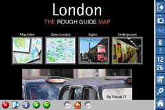
Discover and explore London using full colour interactive linked maps, in this simple to use PDA version of The Rough Guides London.
Find all the top tourist spots and key attractions with ease, information on the city and its sights can be quickly displayed with links to photographs and map locations. All in a superb easy to use interface.
If you''re travelling to London, be sure you don''t leave home without this guide on your PDA.
The Rough Guide city maps includes:
Fully scrollable and interactive maps of the city.
Tap any location to display information and available links.
Intuitive navigation bar meaning you are never more than one click away from the information you require.
Map links allow you to directly link to other maps, photographs, or detailed views.
Categorised Find feature allowing you to quickly find any street, place of interest or station.
Categorised Information feature providing a wealth of information on the city, places of interest, etc.
1-Click Home feature, keeping the Home map always at hand.
Zoom function on all maps.
Special Offer Only $20.00
Hi Res & landscape displays supported.
Like it? Share with your friends!
If you got an error while installing Themes, Software or Games, please, read FAQ.
Supported operating systems:
Pocket PC 2002, Windows Mobile 2003, Windows Mobile 5.0, Windows Mobile 6 Classic, Windows Mobile 6 Professional, Windows Mobile 6.1 Classic, Windows Mobile 6.1 Professional, Windows Mobile 6.5 Professional
Similar Software:
Traffic Vizzion Traffic Vizzion - IMPORTANT: Do not operate this product while driving; park the vehicle first. It is your sole responsibility to place, secure and use your mobile device in a manner that ensures safe driving
Gippos See your location on a map and share this information with your friends. See on a map your contact list users who didn't hide their locations and send messages to them
gpsVP gpsVP works on virtually any Windows platform including mobile ones. It shows vector and raster maps, records and shows tracks, shows multiple navigation parameters, manages and shows waypoints. It aims to be as usable as possible.
What's New in This Release:
· Geoid correction matrix: Updated values Atlantic & east America's
amAze (Sony Ericsson) AmAze is a first of its kind free navigation and local search service. It is free to download and use and it contains wide coverage of maps including aerial photo in Europe, North America, Australia and parts of Asia and Africa
CopanMobile for PocketPC Copan for the Pocket PC - is a very functional and easy-to-use geomatics engineering tool for computing and managing plane surveying and mapping coordinates
Map of HongKong for City Advisor Map of HongKong for City Advisor - HongKong MTR map in Traditional Chinese for City Advisor. The stations can be find by Chinese characters and also by the first pinyin letters.
Instructions:
1. Download the map (zip file)
2. Extract the files in /CityAdvisor/maps
3. Open CityAdvisor -> Maps icon -> Menu -> Refresh
4
amAze (Motorola) AmAze is a first of its kind free navigation and local search service. It is free to download and use and it contains wide coverage of maps including aerial photo in Europe, North America, Australia and parts of Asia and Africa
PrettyEarth PrettyEarth
View maps of Earth with PrettyEarth! See current day and night regions, learn geography by taking the quiz, enjoy relief elevation surfaces and measure distances between locations
LiteTrack LiteTrack is the right tool to record your route, save off-road paths, retrace a way, get your position on the map with detailed gps data (satellite charts, speed and much more)
TravelGoogles TravelGoogles allows you to search and view 5,451 local businesses and services sorted from local distance from your home settings. Set your home location in the settings box and tap on a service on the list to view local listings. The business directory service is provided by Google
Other Software by developer «Visual IT»:
Tube 2 Berlin (Palm OS) Tube 2 Berlin (Palm OS) - This map package for Tube 2 consists of a fully scrollable detailed map of the Berlin Metro (U-Bahn/S-Bahn).
Plan journeys on this system, list details of the quickest routes and see a superb animated display of your journey tracking around the system map.
Berlin is the capital and largest city in Germany
San Francisco Metro 10 for iPad San Francisco Metro 10 for iPad - The new San Francisco Metro 10 application makes it easy to travel in and around the city using the Metro (BART), Streetcar, Light Rail(MUNI), Ferry and Presidio shuttle bus services
Washington Metro for iPad by Zuti Washington Metro for iPad by Zuti - The new Washington Metro 10 map makes it easy to travel in and around the city using the WMATA Metro, MARC and VME systems. Also included are the Potomac river taxi routes and the DC Circulator bus routes
TUBE 2 New York City (Blackberry) TUBE 2 New York City (Blackberry)
Tube 2 New York City
Transform your Blackberry into a fully scrollable detailed map of the New York City MTA subway system.
Plan journeys on the New York City subway system, have the quickest routes to hand, with all the details you need including line changes, platform directions and accurate journey times
Tube 2 London Geo (Palm OS) Tube 2 London Geo (Palm OS) - This superb map package for Tube 2 is the ideal map for anyone who needs to get around London using the underground system and would like to know just exactly where they are.
The map geographically accurately locates the central London stations, overlaid onto a street map. Now you can easily see how these stations fit into the real world
TUBE 2 Rome (Palm OS) TUBE 2 Rome (Palm OS) - This map package for Tube 2 consists of a fully scrollable detailed map of the Rome metro & rail system.
Plan journeys on this system, list details of the quickest routes and see a superb animated display of your journey tracking around the system map.
A Pro version is also available with integrated high quality street maps of central Rome
Tube 2 Paris (UIQ3) Tube 2 Paris (UIQ3) - This map package for Tube 2 consists of a fully scrollable detailed map of the Paris metro and RER system.
Plan journeys on this system, list details of the quickest routes and see a superb animated display of your journey tracking around the system map
Tube 2 Madrid (UIQ) Tube 2 Madrid (UIQ) - This map package for Tube 2 consists of a fully scrollable detailed map of the Madrid metro system.
Plan journeys on this system, list details of the quickest routes and see a superb animated display of your journey tracking around the system map
Berlin Metro for iPad by Zuti Berlin Metro for iPad by Zuti - This Berlin Metro map makes it easy to travel in and around the city using the Metro (U-Bahn) Suburban Rail (S-Bahn) and Tram (MetroTram and Straßenbahn) systems
Rough Guides Map Washington DC Rough Guides Map Washington DC... These guides are a series of fantastic interactive maps.
Produced in conjunction with the premier travel publisher Rough Guides.
Discover and explore Washington DC using full colour interactive linked maps, in this simple to use PDA version of The Rough Guides Washington DC


 Hi Res & landscape displays supported.


")


")


")


")
")
")
")
")

