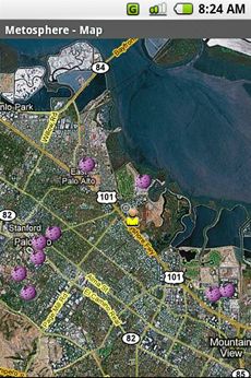
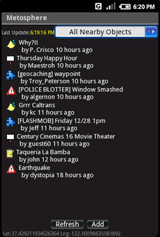
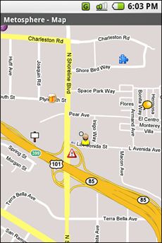
Metosphere Explore and create virtual objects around your physical location like messages, emergency alerts, events, news, reviews, games. View geospatial data from Wikipedia, Eventful, and Upcoming. Start a GeoBlog on your GPS-enabled phone.
This is the core Metosphere Android app. The goal is to follow the Firefox/Eclipse model and provide the ability to create extensions and add-ons like a Geocaching Assistant, Location Messaging Client, Proximity-based KML/GeoRSS Reader, Flash Mob Communicator, Community/Campus Emergency Alert Notifier, or even a Meatspace MUD game.
Like it? Share with your friends!
Supported operating systems:
Google Android 1.0, Google Android 1.5, Google Android 1.6, Google Android 10.x, Google Android 2.0, Google Android 2.1, Google Android 2.2, Google Android 2.3, Google Android 3.0, Google Android 3.1, Google Android 3.2, Google Android 4.0, Google Android 4.1, Google Android 4.2, Google Android 4.3, Google Android 4.4, Google Android 5.x, Google Android 6.x, Google Android 7.x, Google Android 8.x, Google Android 9.x
Similar Software:
Zeen - Building Road Awareness Zeen, building road awareness together! Zeen is a fully featured, community driven mapping solution. - Over 500,000 data points at launch! Will continue to build thanks to the community! - Police Locations - Red Light Camera Locations - Speed Camera Locations - Traffic Reports / Locations
Geopaparazzi Geopaparazzi is a tool developed to do fast qualitative technical and scientific surveys. Its strength is its direct connection to the BeeGIS GIS, that can be used to further process the collected data.
Even if the main aim is in the field of surveying, it contains tools that can be of great use also to tourists that want to keep a geo-diary
TomTom Mexico for Android TomTom Mexico for Android - TomTom Mexico is a turn-by-turn GPS navigator for Android devices. The app includes accurate offline maps, so you can find your way anywhere, even without an internet connection
GPS Status GPS Status is an application which displays the information received from the phone's GPS receiver. In addition to the basic location information it can extract and display the state and location of each visible GPS satellite which is displayed on a simple sky view. The outer circle represents the horizon while the center corresponds to the zenith right above your head
TomTom Italy for Android TomTom Italy for Android - TomTom Italy is a turn-by-turn GPS navigator for Android devices. The app includes accurate offline maps, so you can find your way anywhere, even without an internet connection
GPS Signal Widget GPS Signal Widget - Do you get tired waiting for the GPS location to be available? With this tool you can check out the GPS satellites and the signal strength in just a nice 1X1 widget.
The spokes in the widget represents the satellites and the length of the spokes is a measure of the signal strength.
Enable or disable the widget by tapping on the widget
AndNav2 (Android) AndNav2 is a navigation system for Android-powered phones. AndNav2 is based on free mapdata by OpenStreetMap.org. AndNav2 will provide full audible turn-by-turn realtime route-guidance. AndNav2 has unique features, like Text-2-Speech, an accessibility-study (aka 'Where can I get in 30 minutes') or avoiding customizable areas, i.e
DondeEsta - ultimate SMS mobile tracking system! DondeEsta - ultimate SMS mobile tracking system! - LOCATE YOUR FAMILY SIMPLE SENDING SMS
Install the application in the mobile to be located (i.e. your kid's mobile)
Mobile tracking for family safety.
Locate your children.
Locate elderly.
Locate for your own safety.
Easily alert your family when you are in a trouble!
DondeEstaTM brings peace of mind
GPS Assistant GPS Assistant - GPS Assistant is a simple and intuitive app which shows location data from the GPS receiver. You can check your coordinates (latitude and longitude) and altitude. Additionally, it includes a speedometer.
What's New in This Release:
· Changed ad network
What's New in 1
Boundary Reminder Boundary Reminder - This application is a reminder tool which works with your location. A boundary is registered in drawing a circle on the map, you get a notification when you pass over the boundary.(The application works in background as Service.) Your location data is NOT send to a server
Other Software by developer «metosphere.com»:
not found
Comments on Metosphere (Android):
Comments not found
If you noted an error or download link is broken, please, report it via this page or use comments.
Metosphere (Android) is compatible with your device Pioneer S90w


")
")


")


