GPS speed camera warning application for Android devices. Radardroid will give a visual and audible warning when you approach any fixed or mobile speed camera in the application database. This application will give you advanced warning of possible danger ahead and will reduce possible speeding tickets thanks to the ever increasing available features. We do not condone speeding and will not be held responsible for anybody prosecuted for breaking the law.
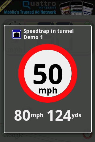
· Voice warnings telling speed camera type and road limit (users can customize these warnings).
· Visual and audible warnings.
· Vibrator warnings (very useful for bikers).
· Change the application settings to prevent the phone to switch off the screen or let the phone dim of switch the screen off to improve your battery life. Even if the screen is off, the application will show the warning dialog, turning the screen on again if needed.
· Day and Night modes.
· Select your screen orientation: portrait, landscape or automatic.
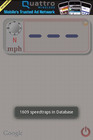
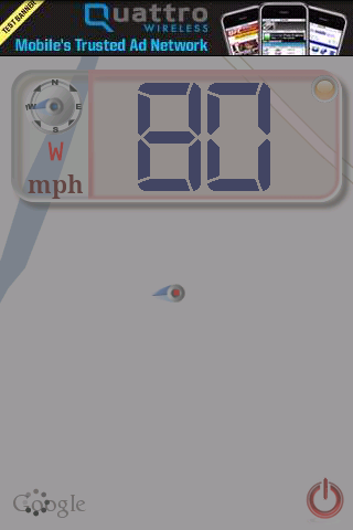
· Radardroid main window is an interactive map which shows the closest speed camera locations. Radardroid also incorporates a digital speedometer that shows your speed and direction.
· Download Speed Camera Database directly from SpeedCameraPOI.com. Keep your database updated with just one click.
· Import your preferred Speed Camera Database from your SD card.
Like it? Share with your friends!
Supported operating systems:
Google Android 1.0, Google Android 1.5, Google Android 1.6, Google Android 10.x, Google Android 2.0, Google Android 2.1, Google Android 2.2, Google Android 2.3, Google Android 3.0, Google Android 3.1, Google Android 3.2, Google Android 4.0, Google Android 4.1, Google Android 4.2, Google Android 4.3, Google Android 4.4, Google Android 5.x, Google Android 6.x, Google Android 7.x, Google Android 8.x, Google Android 9.x
Similar Software:
GPS Status & Toolbox GPS Status & Toolbox - Be a GEEK: Get the most out of your phone. Raw GPS data at your fingertips.
Display your GPS and sensor data: position and signal strength of satellites, accuracy, speed, acceleration, bearing.
Tools included: compass with magnetic and true north, leveling tool, mark or share your location and navigate back later
Foursquare Foursquare - helps you explore the world around you. Keep up with friends, get insider tips, and unlock discounts and rewards.
While on the go, you can easily tell friends where you are, share pictures, get their comments ("I'm right around the corner, I'll stop by to say hello"), and get insider tips ("order the Lobster Ravioli; it's the best dish by far
TomTom Iberia for Android TomTom Iberia for Android - TomTom Iberia is a turn-by-turn GPS navigator for Android devices. The app includes accurate offline maps, so you can find your way anywhere, even without an internet connection
POSIT POSIT (Portable Open Search and Identification Tool) is a Humanitarian Free and Open Source Software project to use the Google Android phone as a platform for mobile disaster management applications
2GIS 2 gis - is a useful mobile navigator which allows you to use maps in offline mode after you download data of a certain city. The application will easily help you find the needed address, telephone and working time of organizations and will offer several options regarding the best route
GPS Assistant GPS Assistant - GPS Assistant is a simple and intuitive app which shows location data from the GPS receiver. You can check your coordinates (latitude and longitude) and altitude. Additionally, it includes a speedometer.
What's New in This Release:
· Changed ad network
What's New in 1
BigTinCan Speed Proof Speed Proof logs your current speed, location and so on to a GPX file as fast as the GPS chip updates the system
Car Tracking Solutions Car Tracking Solutions is a provider of GPS Tracking and Vehicle Management. We provide a 24/7 monitoring service with operators standing by to assist you. We work hand on hand with the Royal Bahamas Police Force to assist with a quick response with vehicle recovery
GPS Widget GPS Widget - This widget simply shows your current location in numbers. Latitude and Longitude are received from the GPS location provider or from the network location provider if GPS is not available.
The altitude is queried from open MapQuest API which yields in a more accurate result than receiving the altitude by GPS
OakLogAndroid OakLogAndroid Logger application for your Android device. Records GPS and sensor information on your phone.
The log files (*.olg) can later be loaded into TrackView.NET and viewed in all their 3D-glory.
· Logs GPS position, altitude, speed, etc
Other Software by developer «Radardroid»:
not found
Comments on Radardroid Lite:
Comments not found
If you noted an error or download link is broken, please, report it via this page or use comments.
Radardroid Lite is compatible with your device Planet Computers Astro Slide 5G Transformer Global Dual SIM TD-LTE 128GB