US Terrain Intelligence for Android - The Outdoor Navigation software is your best friend through your adventures in the wild.
Go into the outdoors with confidence and enjoy your activities without worrying about the tools to help you navigate. Your Outdoor Navigation app is made by the people who have been developing this software since 2003 across multiple platforms. Be sure that you will stay ahead of the rest with continuous updates and relevant tools.
It is an excellent tool for biking, jogging, skiing, hiking, geocaching, boating, flying and many other sporting activities.
United States Terrain Intelligence will give you access to the most sophisticated Ground Guidance technology and allow you to take advantage of services that have only been available to military personal until now.
Terrain Intelligence takes into account a multitude of variables, including elevation, land cover and aerial aspects to calculate the best possible route.
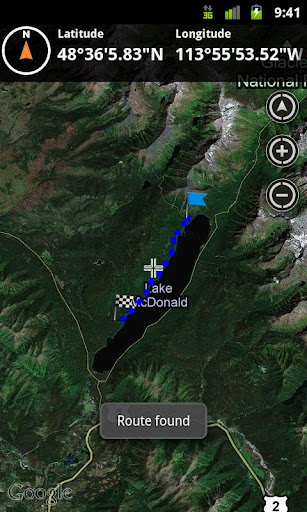
To plan your your off road activities:
· Select Terrain Intelligence as Routing Type in Options
· Route Settings
· Tap on the map to select start and end off road points
· Route will be calculated using Terrain Intelligence service
This plugin works only in the USA.
Installation instructions:
Outdoor US Terrain Intelligence is an add-on for the free Outdoor Navigation application. You need to have your Outdoor Navigation installed to be able to use Outdoor US Terrain Intelligence.
Download and install Outdoor US Terrain Intelligence on your Android device. Start the Outdoor US Terrain Intelligence plugin to complete the license checking: when activation will be completed then the icon will be removed (you need to restart your device to hide the icon) and the plugin will be used inside Outdoor Navigation application
What's New in This Release:
· Bug fixing
Like it? Share with your friends!
Supported operating systems:
Google Android 10.x, Google Android 2.1, Google Android 2.2, Google Android 2.3, Google Android 3.0, Google Android 3.1, Google Android 3.2, Google Android 4.0, Google Android 4.1, Google Android 4.2, Google Android 4.3, Google Android 4.4, Google Android 5.x, Google Android 6.x, Google Android 7.x, Google Android 8.x, Google Android 9.x
Similar Software:
Wildlife Sanctuaries and National Parks of India Wildlife Sanctuaries and National Parks of India - India has 515 animal sanctuaries referred to as Wildlife sanctuaries Category IV Protected Area Among these, the 41 Tiger Reserves are governed by Project Tiger, and are of special significance in the conservation of the tiger. Some wildlife sanctuaries are specifically named Bird Sanctuary, e.g
Müzeler Bilgi Yarismasi Kendinizi deneyin, Muzeler bilginizi olcun! Bilgi yarismasi sevenler buraya! Bilgi yarismalari serisinde; en cok kategoride en cok dogru cevabi siz bilin, siralamada en ustte yer alin. 30 soruluk bu bilgi yarismasinda iyi sanslar
Most Beautiful Valleys In The World Most Beautiful Valleys In The World - The world is a wonderful place. Today we decided to present you the most beautiful and famous valleys in the world. From the steep valleys of the Himalayas to the picturesque valleys found high in the Alps, these are many of the most beautiful valleys in the world
Indias Republic Day Indias Republic Day - In India, Republic Day honours the date on which the Constitution of India came into force on 26 January 1950 replacing the Government of India Act (1935) as the governing document of India
Park Park - Best Android Parking Application for the people who travel regularly.
For Android devices running Android OS 1.5 and above
Features:
Park your car and you can enter voice/text note.
Automatically displays the map where gps is available.
Saves the Parked Location.
You can play/view the parked location details
Geogad Mobile Tours Geogad Mobile Tours - change your mobile device into your personal mobile tour guide with audio and video tours.
Explore popular travel destinations with video and audio clips. Search for tour stops, and upload your own video tour stops from your phone
Closest Nuclear Power Plant Closest Nuclear Power Plant - Determines your place on earth and calculates the distance to the closest nuclear power plant. Draws an arrow and gives the distance to the closest nuclear power plant. If you get dangerously close to the power plant the arrow gets redder and redder
CouponMap "CouponMap" recommends and maps local restaurants in Japan. NOTE: THE CURRENT VERSION ONLY SEARCHES AREA IN JAPAN. "CouponMap" recommends and maps local restaurants searched by "Gourmet Navigator" & "Hot Pepper"
Most Amazing Botanical Gardens Most Amazing Botanical Gardens - For many of us, botanical gardens and arboretums are beautiful places to visit and serve as peaceful settings for relaxation, family time, or recreation. The gardens and arboretums on this list, however, serve a higher purpose
Other Software by developer «GPS Tuner»:
GPS Tuner Essentials Full Version with Central Europe Basic Map Content GPS Tuner Essentials Full Version with Central Europe Basic Map Content is designed specifically for off-road use: its large buttons, selectable tool window size, multiple Compass views and the built-in Tele Atlas map makes it extremely user-friendly and reliable
GPS Tuner Essentials Full Version with Canada Basic Map Content GPS Tuner Essentials Full Version with Canada Basic Map Content is designed specifically for off-road use: its large buttons, selectable tool window size, multiple Compass views and the built-in Tele Atlas map makes it extremely user-friendly and reliable
GPS Tuner Essentials Full Version with British Isles Basic Map Content GPS Tuner Essentials Full Version with British Isles Basic Map Content is designed specifically for off-road use: its large buttons, selectable tool window size, multiple Compass views and the built-in Tele Atlas map makes it extremely user-friendly and reliable
Outdoor Compass for Android Outdoor Compass for Android - The Outdoor Navigation software is your best friend through your adventures in the wild.
Go into the outdoors with confidence and enjoy your activities without worrying about the tools to help you navigate. Your Outdoor Navigation app is made by the people who have been developing this software since 2003 across multiple platforms
Outdoor Speedometer for Android Outdoor Speedometer for Android - The Outdoor Navigation software is your best friend through your adventures in the wild.
Go into the outdoors with confidence and enjoy your activities without worrying about the tools to help you navigate. Your Outdoor Navigation app is made by the people who have been developing this software since 2003 across multiple platforms
Outdoor Chart for Android Outdoor Chart for Android - The Outdoor Navigation software is your best friend through your adventures in the wild.
Go into the outdoors with confidence and enjoy your activities without worrying about the tools to help you navigate. Your Outdoor Navigation app is made by the people who have been developing this software since 2003 across multiple platforms
Outdoor Offline Maps for Android Outdoor Offline Maps for Android - The Outdoor Navigation software is your best friend through your adventures in the wild.
Go into the outdoors with confidence and enjoy your activities without worrying about the tools to help you navigate. Your Outdoor Navigation app is made by the people who have been developing this software since 2003 across multiple platforms
GPS Tuner Essentials Full Version with Germany, Austria, Switzerland Basic Map Content GPS Tuner Essentials Full Version with Germany, Austria, Switzerland Basic Map Content is designed specifically for off-road use: its large buttons, selectable tool window size, multiple Compass views and the built-in Tele Atlas map makes it extremely user-friendly and reliable
GPS Tuner Essentials GPS Tuner Essentials is designed specifically for off-road use: its large buttons, selectable tool window size, multiple Compass views make it extremely user-friendly and reliable
GPS Tuner Essentials Full Version with United States Basic Map Content GPS Tuner Essentials Full Version with United States Basic Map Content is designed specifically for off-road use: its large buttons, selectable tool window size, multiple Compass views and the built-in Tele Atlas map makes it extremely user-friendly and reliable