Map Locate Ad - This app is not created to replace Google Maps or other feature rich mapping apps. What this app does is to serve a simple need for certain group of users. Use case is you own jpg,png image files of tradeshow,house,store,apartment,garden etc floorplan and you want to draw pins on different location within the floorplan. Upon tap the pin you want to store some information for that location. So from user perspective, you see the floorplan with pins on them.
App works by assuming the jpg,png floorplan image files are split into many squares along X and Y axis. Each square is then where the app will draw pin in them.
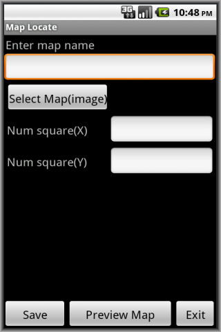
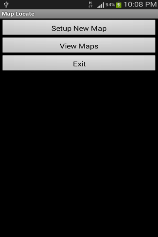
To use, tap Setup New Map. Give a map name, tap Select Map(image) to bring in your jpg,png image file from Gallery. Give a value for number of squares for X and Y axis. Tap Preview Map to preview and notice app take origin (0,0) as bottom left corner. Tap Save to save the map.
Then go to tap View Maps. Tap Edit to change the number of squares for X and Y axis (if you wish). Tap View to see your map. This is where you start to add pins to the map. At the top, specify the X,Y value then tap Add Pin. Pin appear on map. Tap on that pin and a pop-up appear. Add your own location specific information and tap Save. Pinch to zoom in is supported. This help you to see the pin and surrounding close-up. To get back to original, tap the 1:1 button on top. Tap the Grid button to toggle grid on and off.
Important points to note:
- Since most floorplan images are huge, try to scale the image in advance to dimension close to the smart-phone screen size. This ensure when the app render the image it is close to original and your pins drawn on top will look nice.
The application support English, Simplified Chinese, Traditional Chinese display.
Like it? Share with your friends!
Supported operating systems:
Google Android 10.x, Google Android 2.3, Google Android 3.0, Google Android 3.1, Google Android 3.2, Google Android 4.0, Google Android 4.1, Google Android 4.2, Google Android 4.3, Google Android 4.4, Google Android 5.x, Google Android 6.x, Google Android 7.x, Google Android 8.x, Google Android 9.x
Similar Software:
BostonBusMap BostonBusMap is an application for Android phones. It uses GPS data provided by the MBTA to plot the real-time location of buses on a map.
What's New in This Release:
· GPS now turns on when you start the app to allow quicker location lookup times
flea papa flea papa Care about your communities by knowing what people near you are thinking, saying, doing, selling, wanting and needing. With a patent-pending Search By Route technology, you can also connect with people or objects of interest along travel routes when you are on a trip
CopsAlarm No more tickets Show where the hiding police are on Google Map As well as speed cam,red light locations Lite shows police,red lights only
CoPilot Live UK + Ireland (Android) CoPilot Live UK + Ireland (Android) - CoPilot Live is full-featured voice-guided GPS navigation with street maps of 1 European region stored on your Android phone. Includes 3D guidance, lane assist, speed limit warnings, safety camera alerts, planning mode.
Download maps via WiFi after purchase. Unlimited use after 10 days once Google order verified
CoPilot Live Australia & NZ (Android) CoPilot Live Australia & NZ (Android) - Get a CoPilot! The onboard GPS navigation app that makes every journey better
JTrip JTrip - Create your own trip in Thailand. JTrip recommends attractions and directions that you need. Let's get to know Thailand together.
· select places.
· select hotel.
· show map location.
· route path form src to dest.
· taxi, time remaining.
· suggest bus number
MAPS.ME for Android MAPS.ME for Android - MapsWithMe allows you to access maps of all the countries in the world while on the go. The maps are based on OpenStreetMap data and work completely offline, without requiring an internet connection
CoPilot Live Premium Europe (Android) CoPilot Live Premium Europe (Android) - Now there’s a better way to navigate.
CoPilot Live Premium is the essential voice-guided sat navigation app to get you where you need to go, by the way that suits you best
Locus Free Locus Free - Fast and useful Online/Offline map viewer for Android.
· This is also My Maps editor so Google Account permission is needed
· Contacts permission is for getting contact address on various places in app (adding point into database by contact address, etc..
AugSatNav Walk AugSatNav is an augmented reality navigation system which overlays walking directions upon a live video feed of the path or road ahead.
With AugSatNav there is no need to follow instructions or interpret maps - you can simply find your way by walking along the route highlighted by a bright white line
Other Software by developer «Sohguanh»:
Light Up Ad For concert-goers, usually there will be some slow songs segment where everyone will hold up their glow sticks or zippo lighters with fire or candles etc to wave in the air and sway together with the songs performed
Check Them Check Them - This app does not aim to replace the existing public domain websites that provide the most up-to-date earthquake,hurricane/storm,tsunami, volcano information daily. What it does is to consolidate summary information from all the various websites into a single app for easy monitoring
Pie Timer Ad This "count-up timer" app is to serve two audience. For adults, you have your familiar timer display format. For young toddlers who don't know how to read numbers yet, there is a round pie or circle that act like a timer
Media Alarm Ad We are very familiar with the default alarm which will sound on a time we set earlier. This app add more fun to it. Besides the sound, we can configure to have a picture or even a video to play along when the alarm sound
Call Purpose Ad Some users are given company issued phones. The phone bills are paid for by company too. However some companies would like to ensure that calls received and dial-ed out are strictly for business purposes
Housekeep Files Ad Housekeep Files Ad - For some people who want to do simple housekeep of deleting un-wanted files in your sd-card mass volume based on files are how old, this app is to serve that need.
To configure, set the folder (at least one), file extension (optional), file time-stamp in terms of how many days,hours,minutes old at least
My Sensors Ad For those Android smart-phones that have various sensors built-in, this app attempt to access and retrieve values for display. Three common sensors are shown. Light, Temperature, 3-axis Magnetic field
Carpenter Aid Ad Carpenter Aid Ad - This app provides a feature that some carpenters or those in the wood log industry may need. Given a log, how many different dimension rectangular board size can be 'get' out from it. By varying the dimension size and quantity, the most optimal number of boards can be determined from the log without too much wastage
Point Where Ad This app does not aim to replace a compass. What it does is to serve a simple need using the accelerator and magnetic sensors in Android phone to point direction. For some people, you need to know the direction of a place/city reference to your own location
Space Tracker Ad For users who like to upload download transfer files frequently, finding whether there are enough space on sdcard or phone is monotonous affair. Using the default Settings app provide that info but this widget app go further


")
")


")

