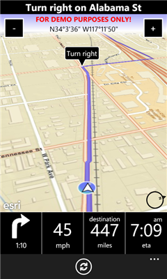
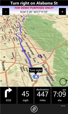
A-to-B is a Turn-by-Turn application built to demonstrate some of the capabilities of the ArcGIS API for Windows Phone.
Warning: The application is meant for demonstration purposes only! Do not rely solely on the suggested routes or instructions given by this application.
Features:
- Turn-by-turn routing. Sound notification when a turn is coming up.
- Add often used destinations as favorites.
- List of recent destinations.
- "3D view" when in navigation mode with easy accessible "zoom in/out" buttons.
- 2D Map for browsing the map supporting pinching, panning etc, and pick new destination by touch'n'hold on the map.
- Easy accessible "Recalculate" button if you go off the route and need a new route from your current location (because of service restrictions, the app is not allowed to do this automatically).
- Routes all over US (support for Europe coming in a future version).
- Worldwide map (detail may vary).
Like it? Share with your friends!
If you got an error while installing Themes, Software or Games, please, read FAQ.
Supported operating systems:
Windows 10 Mobile, Windows Phone 7, Windows Phone 8
Similar Software:
The Weather Channel Weather can make or break your plans, whether it be business travel or a round of golf. With The Weather Channel for Windows Mobile, you'll have the latest weather information at your fingertips so you can plan more efficiently
DiaryGPS DiaryGPS - DiaryGPS can be used to make text diary notes based on your GPS. For each day the program creates a subfolder under the current storage folder with the text notes. You can view the notes via distance. Tap on the diary entry to view.
This program requires that you have both the 'BeanDLL
FON Access Points for Germany FON Access Points for Germany - FON offers you a new Points of Interest service (POIs). This allows you to download FONspots directly to your navigation device.
What does that mean? You can download a Points of Interest file directly to your navigation device
FileGPSed FileGPSed - FileGPSed allows browse and view GPS tagged Excel, Word, Note, Voice, Text and Picture/Video files. You can browse the folders of the PocketPC for GPS tagged files and view them via GPS distance from your current location. Tap on the file to open it in the associated application.
This program requires that you have both the 'BeanDLL
JVTrip JVTrip - Track yourself while you are on a trip, walking, cycling, driving or just watch your child move. And then export the path to Google Earth.
You can add notes, costs or pictures to your path. This information will be stored with the GPS location where you added them. When you export your track to Google Earth, all information will be there as markers
MapFingerer MapFingerer - MapFingerer allows you use the GPS on your device or custom GPS values to download maps from Google.com and keeps them in a finger friendly database. You can make multiple pages for the maps. Tap on the map to button to view it.
This program requires that you have both the 'BeanDLL
amAze (Sony Ericsson) AmAze is a first of its kind free navigation and local search service. It is free to download and use and it contains wide coverage of maps including aerial photo in Europe, North America, Australia and parts of Asia and Africa
Loki Mobile Loki Mobile-Loki Mobile allows you to locate yourself and search locally on any WiFi-enabled device.
Loki is the first application in history that automatically uses your exact physical location to harness the power of the Internet
FON Access Points for Sweden FON Access Points for Sweden - FON offers you a new Points of Interest service (POIs). This allows you to download FONspots directly to your navigation device.
What does that mean? You can download a Points of Interest file directly to your navigation device
GPSSateliter GPSSateliter displays the GPS satellite listings and strength as a graph. When you tap the 'Start GPS' button the program will look for GPS satellites and graphically display the decibel of each. The more bars the better your GPS coverage
Other Software by developer «Morten Nielsen»:
GuidePost GuidePost - This app creates a "Guide Post" with signs on a pole showing distances and direction to any point in the world, relative to where you are. You have probably seen these at various sites all over the world, or in the TV Show "M*A*S*H".
You can also display a map of your location and the shortest paths to your points of interest.
v1


")


