Chicago Maps - Offline (no data connection necessary!) public transportation maps for the Chicago area. Click on the thumbnails and zoom in for a detailed look.
Includes:
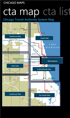
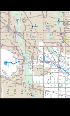
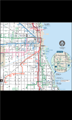
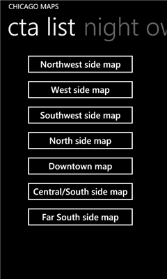
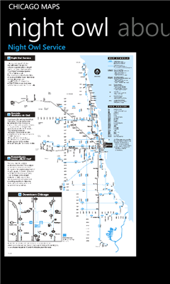
1. an overview of the Chicago Transit Authority system with the ability to zoom into different sections using a map and/or a list
2. Night Owl bus map
Can be used in portrait or landscape view.
Like it? Share with your friends!
If you got an error while installing Themes, Software or Games, please, read FAQ.
Supported operating systems:
Windows 10 Mobile, Windows Phone 7, Windows Phone 8
Similar Software:
KingMAP2 USA-New York Electronic Map KingMAP2 USA-New York Electronic Map is an Electronic Map Navigation Software exclusively for Pocket PC use; besides powerful functions provided for car navigation, it also comprises integrated Electronic Map functions with an abundant information database.
KingMAP™ 2 Features:
-Latest version Europe electronic map database*
-Advanced Car Navigation Technology
Map4Fun Hong Kong Map4Fun Hong Kong - Going to Hong Kong? just download it for free!
Attractions and shops/hotels/restaurants... in Honk Kong, find coupons/POI instant video/communication links...on hand, and much more of major Asian cities at Map4fun.
1. Hong Kong Information.
2. Useful numbers. 3. Tourist attraction.
4. Sheung Wan/Central area map.
5
redBANG Beijing Map-Guide NEW 2006 THE BEST MOBILE GRAPHICS YOU HAVE EVER SET YOUR EYES ON
This City map-Guide contains all THE TOP locations at your finger tips. Simple and easy to use, simply zoom in & out of this jpg map or move N, E, S or West
Pocket World Info & Maps 2.1 Menue
Pocket World gives you the whole world in your pocket. At any time, one click will bring you 133 facts from each of 272 countries. Facts such as currency, population growth, life expectancy, inflation rate, rate of exchange, international relations, political personalities, and more
Map of Washington (US State) Map of Washington (US State) - A map of the Washington by VITO Technology. Good for intercity travels with SmartMap.
SmartMap is a mobile device application which uses vector and raster maps. It is compatible with any NMEA protocol GPS receiver (Compact Flash socket, serial port, BlueTooth or sleeve)
Map of Sweden Map of Sweden - Set of 2 maps of Sweden accompanied by a short text description.
SWEDEN (NORTH)
SWEDEN (SOUTH)
Good for intercity travels with SmartMap
Map of Oman Map of Oman - A map of Oman, divided into 8 smaller territories for the ease of use.
MUSANDAM
AL BATINAH
AL ZANIRAH
MASQAT
AD DAKHILIYAH
ASH SHARQIYAH
AL WUSTA
ZUFAR
Good for intercity travels with SmartMap
redBANG Shenzhen 18 TOP SIGHTS 2006 THE BEST MOBILE GRAPHICS YOU HAVE EVER SET YOUR EYES ON
This TOP 18 sights map contains all THE TOP locations at your finger tips. Simple and easy to use multi step zoom in & out function map as well as movement in any direction
Map of Thailand Map of Thailand - A map of Thailand, divided into 72 smaller territories for the ease of use. Good for intercity travels with SmartMap.
Layers include: Towns - Settlements - Airports - Roads - Railroads - Rivers - Inland water - Administrative borders - International borders - Trees. Map scale is 1:1 million.
Good for use with any version of SmartMap
Other Software by developer «Pegus Co»:
San Francisco Facts San Francisco Facts - San Francisco Facts app features information about San Francisco, CA in the following 12 sections:
1. About San Francisco
2. Geography
3. Climate
4. Government
5. Neighborhoods
6. Culture
7. Education
8. Media
9. Sports
10. Economy
11. Demographics
12
Boston Facts Boston Facts app features information about Boston, MA in the following 12 sections:
1. About Boston
2. Geography
3. Climate
4. Crime
5. Neighborhoods
6. Culture
7. Education
8. Media
9. Sports
10. Economy
11. Demographics
12
Indianapolis Facts Indianapolis Facts - Indianapolis Facts app features information about Indianapolis, Indiana in the following 11 sections:
1. About Indianapolis
2. History
3. Geography
4. Climate
5. Demographics
6. Economy
7. Attractions
8. Sports
9. Government
10. Education
11
Prague Maps Prague Maps - This app contains offline (no data plan/reception necessary) public transportation maps for the Prague area, including tourist maps, metro/tram maps, and the Airport Express, which takes you from Prague Airport to popular the main train station, Hlavni Nadrazi
Columbus Facts Columbus Facts - Columbus Facts app features information about Columbus, Ohio in the following 11 sections:
1. About Columbus
2. History
3. Geography
4. Climate
5. Demographics
6. Economy
7. Attractions
8. Sports
9. Government
10. Education
11
Houston Facts Houston Facts app features information about Houston, TX in the following 12 sections:
1. About New York City
2. Geography
3. Climate
4. Cityscape
5. Government
6. Culture
7. Education
8. Media
9. Sports
10. Economy
11. Demographics
12
Boston Maps Boston Maps - This app contains offline public (no data connection necessary after first download) transportation maps for the Boston area.
Includes
subway
commuter rail
commuter boat
water taxi
Boston detail maps
MBTA system maps
Can be used in portrait or landscape view
New York City Facts New York City Facts - New York City Facts app features information about New York City, NY in the following 13 sections:
1. About New York City
2. Geography
3. Climate
4. Architecture
5. Boroughs
6. Entertainment
7. Tourism
8. Media
9. Cuisine
10. Sports
11. Economy
12. Demographics
13
Los Angeles Facts Los Angeles Facts - Los Angeles Facts app features information about Los Angeles, CA in the following 12 sections:
1. About New York City
2. Geography
3. Climate
4. Landmarks
5. City sections
6. Culture
7. Education
8. Media
9. Sports
10. Economy
11. Demographics
12
Cambridge Facts Cambridge Facts - Cambridge Facts app features information about Cambridge, MA in the following 10 sections:
1. About Cambridge, MA
2. Geography
3. Parks
4. Government
5. Culture
6. Education
7. Media
8. Economy
9. Demographics
10


")


