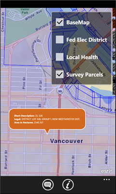
GeoBC Showcase - This app takes advantage of geospatial layers provided by GeoBC. It will include Federal Electoral Districts and Local Health areas plus Primary Survey Parcels in British Columbia, Canada.
Select one of the layers from the list, then press a point on the map and hold to get information about that geographical point.
Like it? Share with your friends!
If you got an error while installing Themes, Software or Games, please, read FAQ.
Supported operating systems:
Windows 10 Mobile, Windows Phone 7, Windows Phone 8
Similar Software:
Map of South Dakota (US State) Map of South Dakota (US State) - A map of the South Dakota by VITO Technology. Good for intercity travels with SmartMap.
SmartMap is a mobile device application which uses vector and raster maps. It is compatible with any NMEA protocol GPS receiver (Compact Flash socket, serial port, BlueTooth or sleeve)
Map of Serbia Map of Serbia - A map of Serbia good for intercity travels with SmartMap.
Layers include:
Towns
Settlements
Airports
Roads
Railroads
Rivers
Inland water
Administrative borders
International borders
Trees
Map scale is 1:1 million.
Good for use with any version of SmartMap. SmartMap can be purchased here
J2ME OGC WMS Client J2ME OGC WMS Client is a program for accessing OGC Web map services from Java enabled mobile phone or PDAs.
It accesses the OGC WMS according to WMS 1.1.0 and 1.1.1 specifications and supports zooming and panning in the Map, WMS sublayers, and a bookmark management system for quick access.
Free for non-commercial use
SmartCaddie Pro SmartCaddie Pro with GPS
Thousands of courses, if your course is not there we will simply add it for you
12 players or more, special versions are available for leagues.
Includes enrolment for one user in the Nova Golf Internet Network (NGIN) providing further features and functions
MapKing 2007 BeiJing PPC Map in English MapKing 2007 BeiJing PPC Map in English - MapKing 2007 New Functions: More different profile Compass mode Open Tour book (need to connect to pc to edit) Support VGA monitor Nine intelligent map query (index/Crossing/ Q-find/POI/ position/City/Town/ Lat/Long/Keyword) Customer Support will not be provided for trial version
TwitterGPSer TwitterGPSer uses the GPS on your PocketPC to find your current latitude/longitude/speed and allows you to update Twitter.com. Tap the button to get the GPS lock and when the program gets the lock it will create a Tweet with a Google.com map link. This service is provided by Twitter
Mobile City Tours Mobile City Tours- with this application you can download and install a walking tour map database for various cities right to your PDA. With this application you have everything you need for your walking tour (including map, pictures and tour information) which is stored right on your device and does not require a connection to the internet
Map of North Dakota (US State) Map of North Dakota (US State) - A map of the North Dakota by VITO Technology. Good for intercity travels with SmartMap.
SmartMap is a mobile device application which uses vector and raster maps. It is compatible with any NMEA protocol GPS receiver (Compact Flash socket, serial port, BlueTooth or sleeve)
Map of Sweden Map of Sweden - Set of 2 maps of Sweden accompanied by a short text description.
SWEDEN (NORTH)
SWEDEN (SOUTH)
Good for intercity travels with SmartMap
Other Software by developer «Dan Bonab»:
not found
Comments on GeoBC Showcase:
Comments not found
If you noted an error or download link is broken, please, report it via this page or use comments.
Please, select device to check if GeoBC Showcase supports it


")


![USA-TN [Tennessee] Map for EagleEye PDA Tracking System](https://static.mobyware.org/data/images/def_program_reduced.png "USA-TN [Tennessee] Map for EagleEye PDA Tracking System")


")
