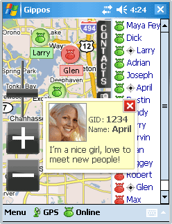
Gippos is mobile software for locating yourself and other users on the map and for instant messaging. Feel the city pace
Do you like to meet new people on the streets? Chat with them for free? Know where your friends are?
Meet and communicate without trouble! Enjoy nature
Arranging a picnic in a beautiful place? Inviting your friends for a country walk? Your friends will easily find you on a map!
· Find your friends on a map
· Meet new people around you
· Chat for free
What's New in This Release:
· Jabber protocol is used for messaging now.
· Jabber users from other servers can be added to contact list.
· Loading last messages to chat log window is added.
· Chat history viewing is added.
· Avatar loading is added.
· "About Gippos" info window is added.
· Maps switching logic is improved.
· Three modes of user's location visibility are implemented.
· New chat statuses are added.
· Gippos auto updating at new version release is added.
· "Don't turn the device off while the application is running" feature is implemented.
· Viewing user's location, history, and profile from chat window is added.
· Manually locating oneself on the map is added.
· Search window interface is changed
Like it? Share with your friends!
If you got an error while installing Themes, Software or Games, please, read FAQ.
Supported operating systems:
Windows Mobile 5.0, Windows Mobile 6 Classic, Windows Mobile 6 Professional, Windows Mobile 6.1 Classic, Windows Mobile 6.1 Professional, Windows Mobile 6.5 Professional
Similar Software:
Find My Car Find My Car - Did you ever park your car and not remember where it was parked? It can be hard to find your car again in this situation. With this application it allows navigate from your current location to your car. It is also possible to store the parking ticket expiry time with a countdown
LocO LocO -Share your GPS position with your friends with LocO. Transmit your GPS Position via LocO to the Net. Only people knowing your Nick can see your Position on http://loco.4ppc.de. Completely free of charge, completely anonymous
PoliceSpeeders PoliceSpeeders - PoliceSpeeders can be used by a police officer for an informal police speed trap. Enter the distance between the two points in settings and metric/imperial and tap the button or joypad when a car hits the start line and then again at the end line. The program calculates the estimated speeds into a log file
FON Access Points for Jordan FON Access Points for Jordan - FON offers you a new Points of Interest service (POIs). This allows you to download FONspots directly to your navigation device.
What does that mean? You can download a Points of Interest file directly to your navigation device
FON Access Points for Andorra FON Access Points for Andorra - FON offers you a new Points of Interest service (POIs). This allows you to download FONspots directly to your navigation device.
What does that mean? You can download a Points of Interest file directly to your navigation device
FON Access Points for El Salvador FON Access Points for El Salvador - FON offers you a new Points of Interest service (POIs). This allows you to download FONspots directly to your navigation device.
What does that mean? You can download a Points of Interest file directly to your navigation device
GPSSateliter GPSSateliter displays the GPS satellite listings and strength as a graph. When you tap the 'Start GPS' button the program will look for GPS satellites and graphically display the decibel of each. The more bars the better your GPS coverage
FON Access Points for Bosnia and Herzegovina FON Access Points for Bosnia and Herzegovina - FON offers you a new Points of Interest service (POIs). This allows you to download FONspots directly to your navigation device.
What does that mean? You can download a Points of Interest file directly to your navigation device
OziExplorerCE OziExplorerCE - OziExplorerCE is moving map software for mobile devices. It uses raster map images which are either scanned or purchased in digital format. It allows you to track your position received from a GPS on a map (moving map)
GPSDisplayer GPSDisplayer is and educational tool that displays the NMEA data that comes from your GPS unit in your device. Select the program port for your GPS and tap the start button to view the NMEA logs from your GPS. The program displays the data on viewable list
Other Software by developer «Gippos»:
not found
Comments on Gippos:
Comments not found
If you noted an error or download link is broken, please, report it via this page or use comments.
Please, select device to check if Gippos supports it