GPS NUT - GPS NUT is a GPS logger allowing you to log GPS tracks while you hike, bike, or drive. Also, load waypoints planned on Google Earth in the KML format to help guide you on to your destinations.
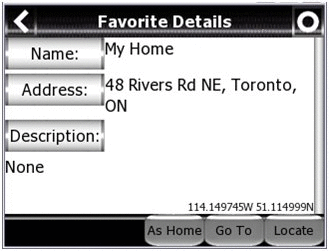
GPS NUT allows you to save GPS waypoints with detailed information to help you find anything. You can store the location of your car in a large parking lot or share the location of a scenic view with others using Google Earth.
· Save GPS logs in Google Earth's KML format.
· Save and Load detailed GPS waypoints in KML format.
· "Locate" items in an hour or a year from now. Find your car in a large mall parking lot or the perfect view atop a nearby mountain. GPS NUT will point to any stored location.
Like it? Share with your friends!
If you got an error while installing Themes, Software or Games, please, read FAQ.
Supported operating systems:
Windows Mobile 6 Classic, Windows Mobile 6 Professional, Windows Mobile 6.1 Classic, Windows Mobile 6.1 Professional, Windows Mobile 6.5 Professional
Similar Software:
GPS Toggle GPS Toggle 1.9 is a today screen plugin for Windows Mobile. It has been designed specifically for the HTC Titan, but should work on most other Windows Mobile phones that have a need for this type of application.
BAF GPS Toggle is written in native code (not .NET), and uses very little memory
MusicGoogler MusicGoogler uses the GPS on your PocketPC to find the 50 closest Music CD and Instrument stores sorted via GPS distance. Tap the button to start the GPS and when you get a lock tap on it to view the list of local stores. You can also dial the store. The GPS maps and store search service is provided by Google
PMWGPSTracking PMWGPSTracking allows you to plot your trip in a file (. KML).
The trace files can then be viewed and compared with Google Earth.
For each track you can define intermediate time (time stamp).
For each lap, the program calculates the duration, average speed and distance.
The trace files can be sent at regular intervals on an FTP server or an email address
FON Access Points for Lebanon FON Access Points for Lebanon - FON offers you a new Points of Interest service (POIs). This allows you to download FONspots directly to your navigation device.
What does that mean? You can download a Points of Interest file directly to your navigation device
PathAway GPS SE PathAway GPS SE - GPS Navigation using your own maps! Convert any digital map, for use on your Pocket PC. Then, attach a compatible GPS (via bluetooth, cable, snap-on, or card) to your handheld, and you have a powerful GPS Moving Map navigation system
GPS Tuner Essentials Full Version with BENELUX Basic Map Content GPS Tuner Essentials Full Version with BENELUX Basic Map Content is designed specifically for off-road use: its large buttons, selectable tool window size, multiple Compass views and the built-in Tele Atlas map makes it extremely user-friendly and reliable
FilesGPSed FilesGPSed - FilesGPSed is a file explorer for files that are GPS-tagged. You can view the distance of each file from your current GPS location ascending distance order in real time. The program updates the distance of all files every 5 seconds based on your current GPS location.
This program requires that you have both the 'BeanDLL
ExcelGPSs ExcelGPSs - ExcelGPSs can be used to make Excel sheets with a GPS tag as the sheet file name. Each time you make a sheet the sheet is named the latitude and longitude of the file. You can store your files on the storage card. You can also view the Excels with Google maps.
This program requires that you have both the 'BeanDLL
RulerZIPeds RulerZIPeds allows you to enter 2 American ZIP codes and converts the ZIP codes into GPS coordinates. The program then calculates the distance between the points. You can also download a Google.com map of the route. This service is provided by USZIP