Pocket World Free is your ultimate pocket guide for over 240 countries around the world. The app that puts the whole world on your fingertips. This free version is full featured, supported by ads.
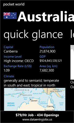
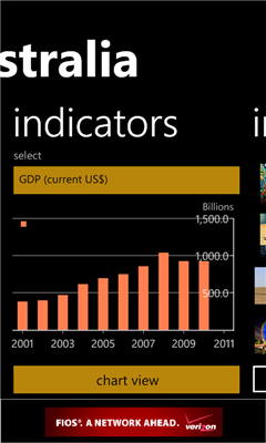
Whether you want to know the capital city of New Zealand, locate Liechtenstein in Europe, find out the weather or history of Argentina, do a bit research on any country on more than 3000 indicators provided by World Bank, or even find out the rankings of GDP for each country, this is the app for you.
Pocket World Features:
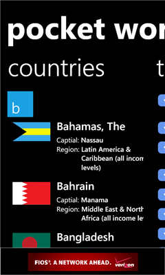
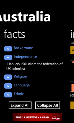
* Wide range of facts on countries around the world, provided and updated yearly by The World FactBook from CIA
* Over 3000 indicators provided by World Bank covering over a dozen major topics of the world. Topics include Agriculture, Education, Energy, Poverty and etc.
* The Favorite page allows you to manage a list of your favorite indicators so you can access them quickly
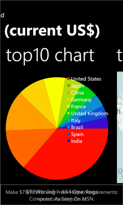
* Show indicator values for each country in each country's individual page, with both chart view and table view
* Interesting images from each country provided by Flickr.com
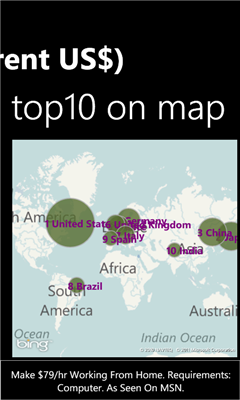
* Visualize top countries per indicator on Bing Map
Like it? Share with your friends!
If you got an error while installing Themes, Software or Games, please, read FAQ.
Supported operating systems:
Windows 10 Mobile, Windows Phone 7, Windows Phone 8
Similar Software:
Map of Hanoi Capital city of Vietnam map. Handmap data file
Map_launcher Map_launcher - WP7 has a several built in launchers, but the map app does not have one. It's unfortunate because I think it's fairly common that you'd want to have a link to get directions in a mobile app since you are, you know, mobile
RadarGPS Making of radars database and dangerous objects
BackCountry Navigator BackCountry Navigator is fun-filled navigation software for the outdoor adventurer. Use it in a variety of outdoor adventures, from kayak touring to geocaching. This is a summary of what you can do with the product.
BackCountry uses free topo and aerial maps for the United States, downloaded directly from Terraserver-USA
Map of Oregon (US State) Map of Oregon (US State) - A map of the Oregon by VITO Technology. Good for intercity travels with SmartMap.
SmartMap is a mobile device application which uses vector and raster maps. It is compatible with any NMEA protocol GPS receiver (Compact Flash socket, serial port, BlueTooth or sleeve)
LiteTrack LiteTrack is the right tool to record your route, save off-road paths, retrace a way, get your position on the map with detailed gps data (satellite charts, speed and much more)
Travel Mammoth Cave National Park - illustrated travel guide and maps- Travel Mammoth Cave National Park is a comprehensive travel guide illustrated with maps and photographs. Indulge Yourself with a personal tour guide on Your PDA. FREE General Information chapter and a map in the trial version.
Features
Fully illustrated.
Geology, Flora, Fauna and more.
Interesting facts.
Area Maps and Trail Maps
Rough Guides Map Madrid Rough Guides Map Madrid... These guides are a series of fantastic interactive maps.
Produced in conjunction with the premier travel publisher Rough Guides.
Discover and explore Madrid using full colour interactive linked maps, in this simple to use PDA version of The Rough Guides Madrid
GPSed Pocket PC GPSed - Record GPS tracks from your mobile and trace them on a map.
Record tracks of your trips anywhere on the Earth from your mobile device. Tracks are traced on Google Maps and stored in an online archive. All you need to start tracking is a mobile device with the internal or external GPS receiver
Other Software by developer «Surface Element Studio»:
not found
Comments on Pocket World Free:
Comments not found
If you noted an error or download link is broken, please, report it via this page or use comments.
Please, select device to check if Pocket World Free supports it


![USA-VT [Vermont] Map for EagleEye PDA Tracking System](https://static.mobyware.org/data/images/def_program_reduced.png "USA-VT [Vermont] Map for EagleEye PDA Tracking System")

")


