Categories: Business & Profession, Travel & Navigation
Upload date: 14 Jul 10
Developer: Sleuth255
License: Freeware
Downloads: 4098 File Size: 92 Kb
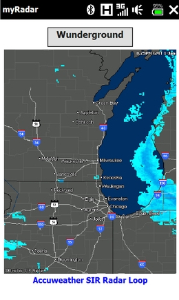
myRadar is a location aware radar application that makes use of Wunderground and Accuweather US web services to show real-time, animated Radar Images of your local area regardless of where in the US you might be. This application requires myLocation services to function automatically.
The program will install to /Program Files/myRadar. A custom png Icon is also located there for those who may wish to install it in Titanium or Manilla. Note: do not install to your SD card.
What's New in This Release:
· Removed the Accuweather feed. Using the Wunderground Feed only. Buttons now allow zoom in/out in 120 mile radius increments.
Like it? Share with your friends!
If you got an error while installing Themes, Software or Games, please, read FAQ.
Supported operating systems:
Pocket PC 2002, Windows Mobile 2003, Windows Mobile 5.0, Windows Mobile 6 Classic, Windows Mobile 6 Professional, Windows Mobile 6.1 Classic, Windows Mobile 6.1 Professional, Windows Mobile 6.5 Professional
Similar Software:
GPSWM65Indicator GPSWM65Indicator uses GPS to find your current coordinates and displays your latitude/longitude on the upper right of your display
VIWay VIWay - VIWay is a small and simple GPS tracking program for WinCE.
How to install VIWay:
· unzip the downloaded file "VIWay.zip"
· copy unzipped directory "VIWay" to any place of your Windows CE device
· change ComPort number and BaudRate inside the file "VIWay
YourGPSPosition YourGPSPosition - This simple app will check your position and show your coordinates and your position on a Bing map.
Disclaimer:
This application is for entertainment purposes only and not intended for use as any means of navigation.
The developer of YourGPSPosition is not responsible for any damages as a result of the use of YourGPSPosition by you or a third party
MyGPS_PDA MyGPS_PDA - MyGPS_PDA is a light MyGPS version for PocketPC systems. It reads the NMEA sentences coming from a GPS antenna connected to the PocketPC and shows your position on a MyGPS calibrated map. The program can also store on a file the track log together with specific waypoints created by the user
OS GPS Convertor OS GPS Convertor converts positions between WGS84 latitude & longitude and Ordnance Survey (OS) British & Irish or Universal Transverse Mercator (UTM) worldwide grid references. It displays positions in multiple formats.
It can be used with:
* TomTom Navigator - to create a Point of Interest (POI) or Itinerary file ... then show on map, navigate to, etc
VoicePOIer VoicePOIer - VoicePOIer is a full-featured named voice recorder with GPS location tagger. You can make named voice recordings and the GPS location is appended to the end of the file. You can browse the files via GPS distance. Tap on the wave file to play it back.
This program requires that you have both the 'BeanDLL
PocketReperion PocketReperion is Windows Mobile Software that brings you instant live GPS Tracking in Google Earth, Virtual Earth and Google Maps.
The client can upload your GPS positions to our server every 10 seconds or more. You can configure the minimal distance that you should move before an update is sent
FON Access Points for French Guiana FON Access Points for French Guiana - FON offers you a new Points of Interest service (POIs). This allows you to download FONspots directly to your navigation device.
What does that mean? You can download a Points of Interest file directly to your navigation device
CU there! CU there! s a useful utility for sending your current position or any other location to your friends, family or colleagues no matter what type of mobile device they own. Just center the position you wish on the map and then choose to send by SMS or email. You may edit the message to be sent as you would on a usual case. Normal SMS charges of your carrier apply
GooglePlaces GooglePlaces is being desing to search your interested places with respect to your current location and range.
1.Quick search places like resturants, shopping mall,banks ,hospitals etc
2.Search with specified name.
3.Use GPS location or Manual location.
4.You can view details in Bing Search by single tap.
5.You can get direction.
6.Save location as snapshot in library
Other Software by developer «Sleuth255»:
myLocation myLocation- It seems like websites and online services are popping up everywhere that can use location to give you more relevant information. Accuweather and others feature location aware weather sites and Google Maps can accept coordinate information to return location aware search results. Of course, with positional awareness comes controversy
PTTFix PTTFix - this little application replaces the Cingular PTT service and adds customizable launch capabilities back to that useless PTT button on your Cingular ROM equipped Hermes. This patch initially maps the PTT button to the built in Voice Dialer, but you can re-map the push as well as the hold functions to the application of your choice
ATI ImageON Fix ATI ImageON Fix - This application fixes the ATI ImageON acceleration bug. This is the bug that causes the screen to "tear" during accelerated video playback using CorePlayer, TCPMP or other players that take advantage of the ImageON hardware acceleration. Once this bug is occurring, the entire screen is unreadable until you somehow exit from the video player
SIPChange SIPChange - SIPChange is for those who can no longer change their defaultIM using the reghacks after upgrading to AKU2.x. No matter what you choose, the keyboard SIP is always selected after a soft reset.
If you aren't having this problem, then you don't need this little app
mySearch mySearch is a location-aware search application that uses Microsoft Bing to return results based on your current position. Just enter in your search term and press the search button to return location specific results!
If your device has HTC's G-Sensor service then simply orient the screen for landscape or portrait mode