Transit Maps USA Free - The only Transit Maps app of its kind. You can select the city you want to see the transit maps for and zoom in to view the map in detail on the full screen. You can easily zoom-in, pan, and zoom-out using one hand only. You can now plan your trip from anywhere, any time - no Internet/data connection required. Imagine having the ease of mind that you will always know what line to catch to go where you want to go.
Give it a try. Your satisfaction is guaranteed.
Please download and rate the app. Provide your feedback via the Marketplace - all comments are read and individually considered.
Tip: Double-tap the zoomed-in map to reset zoom.
The feature history of the application is as below:
Version 1.0 (Current Version)
====================
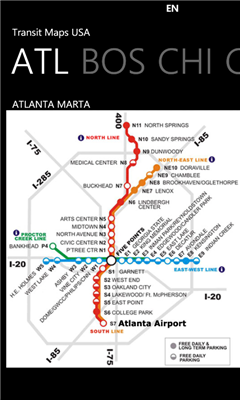
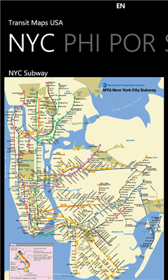
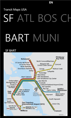
* Transit Maps available for following cities:
- Atlanta
- DC, Washington
- New York City
- San Francisco
* Supports Portrait and Landscape orientation modes
If you would like to get maps for more cities, get the full version of the app at http://social.zune.net/redirect?type=phoneApp&id=e8398409-b46f-e011-81d2-78e7d1fa76f8 The full version contains maps from Boston, Chicago, Los Angeles, Miami, Philadelphia, Portland and more cities.
Like it? Share with your friends!
If you got an error while installing Themes, Software or Games, please, read FAQ.
Supported operating systems:
Windows 10 Mobile, Windows Phone 7, Windows Phone 8
TextMapperer TextMapperer - TextMapperer allows you to create named text based GPS maps. When you get a GPS lock then you can create a new map and enter text for the area. When you save the text the map is downloaded and the text and GPS is appended to the end of the map with current GPS
Map of Slovakia Map of Slovakia - A map of Slovakia, divided into 4 smaller territories for the ease of use.
BRATISLAVA
ZAPADOSLOVENSKY
STREDOSLOVENSKY
VYCHODOSLOVENSKY
Good for intercity travels with SmartMap
Rough Guides Map New York City Rough Guides Map New York City... These guides are a series of fantastic interactive maps.
Produced in conjunction with the premier travel publisher Rough Guides.
Discover and explore New York City using full colour interactive linked maps, in this simple to use PDA version of The Rough Guides New York City
LiteTrack LiteTrack is the right tool to record your route, save off-road paths, retrace a way, get your position on the map with detailed gps data (satellite charts, speed and much more)
MapKing 2007 BeiJing PPC Map in English MapKing 2007 BeiJing PPC Map in English - MapKing 2007 New Functions: More different profile Compass mode Open Tour book (need to connect to pc to edit) Support VGA monitor Nine intelligent map query (index/Crossing/ Q-find/POI/ position/City/Town/ Lat/Long/Keyword) Customer Support will not be provided for trial version
Map of Beijing (Chinese) / China for City Advisor Map of Beijing (Chinese) / China for City Advisor is a Chinese version of Beijing Metro map. Type the first letter of Pinyin to search.
Instructions:
1. Download the map (zip file)
2. Extract the files in /CityAdvisor/maps
3. Open CityAdvisor -> Maps icon -> Menu -> Refresh
4
Map of Thailand Map of Thailand - A map of Thailand, divided into 72 smaller territories for the ease of use. Good for intercity travels with SmartMap.
Layers include: Towns - Settlements - Airports - Roads - Railroads - Rivers - Inland water - Administrative borders - International borders - Trees. Map scale is 1:1 million.
Good for use with any version of SmartMap
DirectionMaps DirectionMaps - This program program allows you to enter a list of locations and 'draw' the maps for them. You can search on the main page and tap the button to view/edit the map.
This program requires that you have both the 'BeanDLL.dll' file ** and ** the runtime files for Visual Basic on your PocketPC computer
Speereo Voice Translator: English-Finnish (WM) Speereo Voice Translator (SVT) is an ideal companion for traveling on business or leisure and also is an excellent aid for business communication. Running on Windows Mobile and Symbian based mobile devices it contains of over 4000 phrases in each of 16+ languages and many other useful features
Other Software by developer «Paras Wadehra»:
SketchPad SketchPad allows you to draw free hand on a canvas on your device using a vast color palette and to save your sketch to keep for memory and show it to others.
You can also load any existing image (or an already saved sketch) as a background and draw on that. You can do things like draw a moustache on someone's face; complete a saved sketch; or write messages for others
NPR News NPR News - Now you can have your news on the go.
Select from various categories (Headlines, Business, Politics, US, World, Technology or Sports) and read individual news stories.
To view the full story, just select "open in ie" from the menu at the bottom of each article - this is currently a limitation of how NPR feeds are setup and not of the app itself
Tic Tac Toe Lite Tic Tac Toe Lite lets you play against the computer or your friend
Artist This is an Artist application where a user can draw free hand like an artist and show their creations to their friends


![USA-LA [Louisiana] Map for EagleEye PDA Tracking System](https://static.mobyware.org/data/images/def_program_reduced.png "USA-LA [Louisiana] Map for EagleEye PDA Tracking System")


 / China for City Advisor")


")


