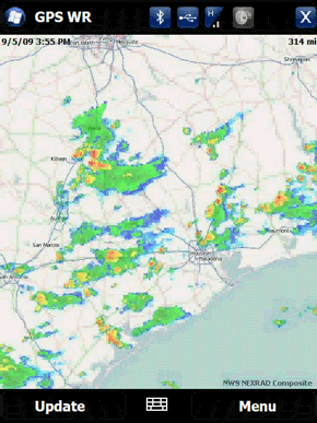
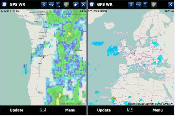
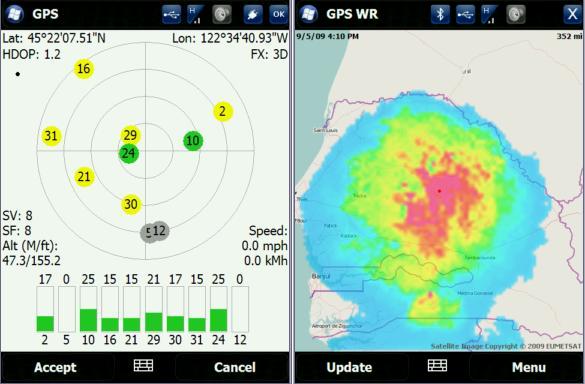
GPS Enabled Weather Radar is weather application that uses your built-in GPS to pull radar images from 3rd party weather services. You can view imaging in satellite or radar formats. It’s currently supported for North America, but it might be possible to add other locations with radar sites.
GPS Enabled Weather Radar Video Preview
GPS Enabled Weather Radar Features:
- Gets weather radar for current GPS location or using cell towers
- Ability to manually enter location
- Click anywhere on the map to move to that location
- Different views and zoom levels
- Animated radar loop
- Integrates with Showaco TitaniumWeather 4.2 PlugIn
New version 2.2.05
- Speed and stability improvements.
- Other minor fixes.
New version 2.2.02
- Added a version for WM Standard (non touchscreen).
- Other minor enhancements.
Like it? Share with your friends!
If you got an error while installing Themes, Software or Games, please, read FAQ.
Supported operating systems:
Windows Mobile 5.0 Smartphone, Windows Mobile 6 Standard, Windows Mobile 6.1 Standard, Windows Mobile 6.5 Standard
Similar Software:
TwitterGPSes TwitterGPSes allows you to view the current GPS and status of your Twitter contacts. Enter the name of each contact to assign to a button. When you tap on the button the persons Twitter page will be downloaded and a Google.com map will display the location. This service is provided by Twitter
PathAway GPS SE PathAway GPS SE - GPS Navigation using your own maps! Convert any digital map, for use on your Pocket PC. Then, attach a compatible GPS (via bluetooth, cable, snap-on, or card) to your handheld, and you have a powerful GPS Moving Map navigation system
FON Access Points for Dominican Republic FON Access Points for Dominican Republic - FON offers you a new Points of Interest service (POIs). This allows you to download FONspots directly to your navigation device.
What does that mean? You can download a Points of Interest file directly to your navigation device
GPSChannels GPSChannels can help you to get a better understanding of the best places to place your unit when trying to get a GPS fix. Start the program and it will display the NMEA logs and the total number of viewable satellites. You can also save the NMEA logs to a file
FON Access Points for Luxembourg FON Access Points for Luxembourg - FON offers you a new Points of Interest service (POIs). This allows you to download FONspots directly to your navigation device.
What does that mean? You can download a Points of Interest file directly to your navigation device
TravelAddresserer TravelAddresserer uses the GPS on your PocketPC to find your current latitude/ longitude/ speed/ altitude and Googles the Country/ Street address and allows you to view your position on a map from the Google.com maps service. You can customize the maps zoom, and type via the 'Options' in the toolbar
FON Access Points for Turkey FON Access Points for Turkey - FON offers you a new Points of Interest service (POIs). This allows you to download FONspots directly to your navigation device.
What does that mean? You can download a Points of Interest file directly to your navigation device
LapLogger GPS (Pocket PC) LapLogger GPS - If you have a Bluetooth GPS and a PDA the sample module will grab the coordinates and render a quick map using a Web map. Your PDA needs internet access. A helpful tool in case you switched cars and need a quick map of your current location. Windows Mobile version has support for regular serial port, internal GPS and Bluetooth GPS
QuickGPS Lite QuickGPS Lite can speed up the time for determining your GPS position by downloading the latest satellite data via an Internet connection (such as GPRS, ActiveSync, etc.).
For quickest connection use:
1. Mod Driver
2. QuickGPS Lite
3. GPS Test
It takes around 10 seconds from cold start to get 9 satellites and have a stable connection
OpenStreetMap OpenStreetMap - Application similar to GoogleMaps but relies on OpenStreetMap.
OpenStreetMap an application similar to GoogleMaps but relies on OpenStreetMap.
It's finger friendly and showing the map on fullscreen.
GPS support and GSM triangulation (if no GPS device is present) is built in
Comments on GPS Enabled Weather Radar:
Comments not found
If you noted an error or download link is broken, please, report it via this page or use comments.
Please, select device to check if GPS Enabled Weather Radar supports it


.jpg)


")

