Symbian OS | Pocket PC | Smartphone | Android | BlackBerry | Apple iPhone OS | Java | Mobile Gaming | Linux | Palm | Win CE | Tablet  
     

Free Mobile Software, Themes, Games, Apps for PDA and Smartphones

     
Search by Device
My Device

  
Search by Category
Business & Profession
Databases
Dictionary & Translator
Entertainment
Finance
Games
Healthcare & Medicine
Internet & Communications
Multimedia & Graphics
Organisation & Productivity
Programming & Development
Reading
Science & Education
System Utilities
Themes & Wallpapers & Skins
Travel & Navigation
Geocaching
GPS
Guides
Maps
Measuring & Compass
Travel Planning
Weather
Worldtime
More
Search by Platform
Android
Apple iPhone OS
iPad
iPhone
iPod Touch
BlackBerry
Java
Linux
Maemo Nokia Internet Tablet
MeeGO
Sharp Zaurus
Mobile Gaming
Nintendo DS
Playstation 3
Playstation Portable
Wii
Xbox 360
Palm OS
Symbian OS
Series 60
Series 80
Series 90
UIQ
Tablet PC
Windows CE.NET
Windows Mobile Pocket PC
Windows Mobile Smartphone


Achivx Partner
 
 
Sunset GPS Logger


Sunset GPS Logger
Version: 3.00

Platforms: Pocket PC


Categories: Travel & Navigation

Upload date: 4 Feb 10

Developer:

License: Freeware

Downloads: 4216

File Size: 740 Kb
Download Free Sunset GPS Logger 


Rating: 2.2/5 (Total votes: 13)


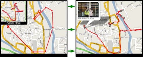
Sunset GPS Logger-allows you to capture your activities (walking, running, cycling, snowboarding, hiking trails .etc) for later visualisation on Google maps. Combined with your existing digital camera it becomes an indispensable tool to simplify the process of geo-tagging those precious photos and memories.

Installation Instructions:
1) Install the application by copying the cab file to your device via ActiveSync then running it on your device.
2) Ensure you have paired up a GPS receiver with your device and have assigned 'com7' as the outgoing devices com, for devices with a built in GPS ensure this is the GPS 'Hardware' port not programme port.
3) To start GPS logging select Menu -> Start GPS Trail.
4) To stop logging select Menu - > Stop GPS Trail.
5) You can find all your GPS logs in the following device directory 'Storage CardGPSLogs'.
6) International locale issue: If you live outside the UK to ensure GPX format compatibility please set you normal number format to the following (English: '.' For decimal and ',' as digit grouping).

Additional Notes: To GPS tag your photos: use the gpx log files in combination with Microsoft's WWMX Location Stamper or DGManager.NET Nb. For the best results ensure that BOTH your Mobile device and Digital cameras date/time settings are identical, as both rely heavily on date/time in GPS tagging your photos.


Like it? Share with your friends!

If you got an error while installing Themes, Software or Games, please, read FAQ.
 

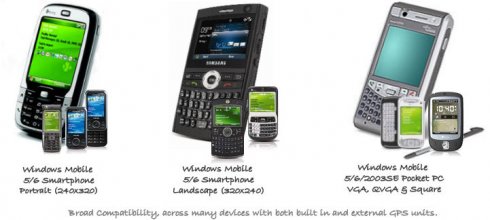
Supported operating systems: Windows Mobile 5.0, Windows Mobile 6 Classic, Windows Mobile 6 Professional, Windows Mobile 6.1 Classic, Windows Mobile 6.1 Professional, Windows Mobile 6.5 Professional
 
Similar Software:

FON Access Points for NicaraguaFON Access Points for Nicaragua
FON Access Points for Nicaragua - FON offers you a new Points of Interest service (POIs). This allows you to download FONspots directly to your navigation device. What does that mean? You can download a Points of Interest file directly to your navigation device
FON Access Points for CameroonFON Access Points for Cameroon
FON Access Points for Cameroon - FON offers you a new Points of Interest service (POIs). This allows you to download FONspots directly to your navigation device. What does that mean? You can download a Points of Interest file directly to your navigation device
FON Access Points for IsraelFON Access Points for Israel
FON Access Points for Israel - FON offers you a new Points of Interest service (POIs). This allows you to download FONspots directly to your navigation device. What does that mean? You can download a Points of Interest file directly to your navigation device
FON Access Points for JapanFON Access Points for Japan
FON Access Points for Japan - FON offers you a new Points of Interest service (POIs). This allows you to download FONspots directly to your navigation device. What does that mean? You can download a Points of Interest file directly to your navigation device
RulerGPSRulerGPS
RulerGPS - This program allows you to calculate the distance in Miles, Feet, Inches, KM, Meters and CM based on two latitude and longitude points. This can be used as a ruler for construction etc. with GPS. This program requires that you have both the 'BeanDLL.dll' file ** and ** the runtime files for Visual Basic on your PocketPC computer
Nova Golf - Platinum with GPSNova Golf - Platinum with GPS
Nova Golf - Platinum Golf System with GPS-This product is superseded by SmartCaddie Pro with GPS Thousands of courses, if your course is not there we will simply add it for you 12 players or more, special versions are available for leagues
PMWGPSTrackingPMWGPSTracking
PMWGPSTracking allows you to plot your trip in a file (. KML). The trace files can then be viewed and compared with Google Earth. For each track you can define intermediate time (time stamp). For each lap, the program calculates the duration, average speed and distance. The trace files can be sent at regular intervals on an FTP server or an email address
ExcelGPSedsExcelGPSeds
ExcelGPSeds - ExcelGPSeds is a full-featured Pocket Excel GPS editor/viewer. When you create a new Pocket Excel sheet the current GPS is appended to the end of the file. You can view the files and edit them or edit the file and update it with your new GPS location. This program requires that you have both the 'BeanDLL
FON Access Points for ZimbabweFON Access Points for Zimbabwe
FON Access Points for Zimbabwe - FON offers you a new Points of Interest service (POIs). This allows you to download FONspots directly to your navigation device. What does that mean? You can download a Points of Interest file directly to your navigation device
GPS Logger 2005GPS Logger 2005
GPS Logger 2005 - Automatically record trip data over days or weeks. Make detailed surveys of topographical features, GIS, boundaries, street furniture, boreholes or any other element for which you wish to store location data. Plot it to CAD or any popular mapping application to produce easy to read graphical representations of your work
 

Comments on Sunset GPS Logger:

Comments not found

Name:


Comment:


Enter text from image below:

Turn on images!


If you noted an error or download link is broken, please, report it via this page or use comments.
 

Please, select device to check if Sunset GPS Logger supports it
 
 
© Pantich 2009 - 2025 All rights reserved.