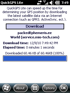
QuickGPS Lite can speed up the time for determining your GPS position by downloading the latest satellite data via an Internet connection (such as GPRS, ActiveSync, etc.).
For quickest connection use:
1. Mod Driver
2. QuickGPS Lite
3. GPS Test
It takes around 10 seconds from cold start to get 9 satellites and have a stable connection.
What's New in This Release:
· Illegal characters in path error, added packedEphemeris server
Like it? Share with your friends!
If you got an error while installing Themes, Software or Games, please, read FAQ.
Supported operating systems:
Windows Mobile 2003, Windows Mobile 5.0, Windows Mobile 6 Classic, Windows Mobile 6 Professional, Windows Mobile 6.1 Classic, Windows Mobile 6.1 Professional, Windows Mobile 6.5 Professional
Similar Software:
FON Access Points for Cambodia FON Access Points for Cambodia - FON offers you a new Points of Interest service (POIs). This allows you to download FONspots directly to your navigation device.
What does that mean? You can download a Points of Interest file directly to your navigation device
RulerZIPeds RulerZIPeds allows you to enter 2 American ZIP codes and converts the ZIP codes into GPS coordinates. The program then calculates the distance between the points. You can also download a Google.com map of the route. This service is provided by USZIP
OS GPS Convertor OS GPS Convertor converts positions between WGS84 latitude & longitude and Ordnance Survey (OS) British & Irish or Universal Transverse Mercator (UTM) worldwide grid references. It displays positions in multiple formats.
It can be used with:
* TomTom Navigator - to create a Point of Interest (POI) or Itinerary file ... then show on map, navigate to, etc
TextMapperer TextMapperer - TextMapperer allows you to create named text based GPS maps. When you get a GPS lock then you can create a new map and enter text for the area. When you save the text the map is downloaded and the text and GPS is appended to the end of the map with current GPS
amAze (Samsung) AmAze is a first of its kind free navigation and local search service. It is free to download and use and it contains wide coverage of maps including aerial photo in Europe, North America, Australia and parts of Asia and Africa
EmailGPSer EmailGPSer - EmailGPSer allows you to build email lists and update a person or all of the people on the list your current GPS. You can send the alert to just one email contact or all on the list. The email has a URL of your GPS from the Google.com maps service.
This program requires that you have both the 'BeanDLL
PictureGPSed PictureGPSed - PictureGPSed checks the camera storage folder for new pictures/videos and when detected places the current GPS tag at the end of the image/video and sends it via email with a Google.com map link. You can also view the images via a distance file viewer. You can also view and download a map of the pictures from Google.com
Terracrosser Terracrosser is a free GPS navigation software for Windows Mobile Pocket PC.
· Terracrosser works in Map and Photo modes
· Terracrosser uses zoomable maps
· Terracrosser is completely compatible with Google Maps service. With included Mapper module you can download maps from the Internet
TimeGPSs TimeGPSs - This program allows you to enter two sets of GPS points and a speed reading in Miles or KM/H. Then the program displays the distance between the two points and the amount of time to travel from each point.
This program requires that you have both the 'BeanDLL.dll' file ** and ** the runtime files for Visual Basic on your PocketPC computer
TerraTrack Recorder 7 Route guidance in 3D view, makes navigation processes very simple and intuitive
Other Software by developer «Vico100»:
not found
Comments on QuickGPS Lite:
siddhu:
jhandu sw not working
Date: 27 Dec 10
If you noted an error or download link is broken, please, report it via this page or use comments.
QuickGPS Lite is compatible with your device QiGi V800


")


