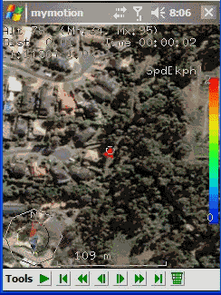
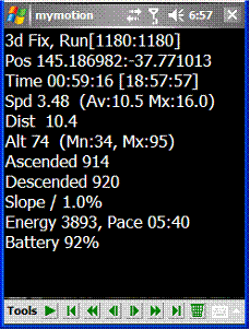
MyMotion - GPS route recording and playback with customizable spoken feedback of speed, distance and time. Uses a moving map to show progress as well as textual output. Maps can be generated from Google Earth installed on a PC using a map creation tool. Allows user to record a route then load it up as a reference for live comparison the next time it is traversed. Optional location tracking of GPS devices with GPRS or 3G, via the web and Google Earth or Google Maps.
· This software is free for personal use.
What's New in This Release:
· Performance Improvements, particularly UI responsiveness.
· User definable default file name format for track save.
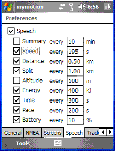
· Add sensitivity enabling for menu items.
· Bug fixes: Fixed arrow direction. Fixed corruption with long (> 32 chars) file names in track files.
Like it? Share with your friends!
If you got an error while installing Themes, Software or Games, please, read FAQ.
Supported operating systems:
Windows Mobile 2003, Windows Mobile 5.0, Windows Mobile 6 Classic, Windows Mobile 6 Professional, Windows Mobile 6.1 Classic, Windows Mobile 6.1 Professional, Windows Mobile 6.5 Professional
Similar Software:
Where I Am Where I Am - a small program using GPS and copies the coordinates in clipboard or builds a link for map in Google pointing to where you are now and saves it into clipboard again. Later all you have to do is only send this link. After installation you have to go to the folder containing this program, open settings
FON Access Points for Fiji FON Access Points for Fiji - FON offers you a new Points of Interest service (POIs). This allows you to download FONspots directly to your navigation device.
What does that mean? You can download a Points of Interest file directly to your navigation device
FON Access Points for Malta FON Access Points for Malta - FON offers you a new Points of Interest service (POIs). This allows you to download FONspots directly to your navigation device.
What does that mean? You can download a Points of Interest file directly to your navigation device
FON Access Points for Mauritius FON Access Points for Mauritius - FON offers you a new Points of Interest service (POIs). This allows you to download FONspots directly to your navigation device.
What does that mean? You can download a Points of Interest file directly to your navigation device
CoffeeGoogler CoffeeGoogler uses the GPS on your PocketPC to find the 50 closest coffee shops sorted via GPS distance. Tap the button to start the GPS and when you get a lock tap on it to view the list of local coffee shops. You can also dial the store. The GPS maps and coffee search service is provided by Google
FON Access Points for South Korea FON Access Points for South Korea - FON offers you a new Points of Interest service (POIs). This allows you to download FONspots directly to your navigation device.
What does that mean? You can download a Points of Interest file directly to your navigation device
MyGPS_PDA MyGPS_PDA - MyGPS_PDA is a light MyGPS version for PocketPC systems. It reads the NMEA sentences coming from a GPS antenna connected to the PocketPC and shows your position on a MyGPS calibrated map. The program can also store on a file the track log together with specific waypoints created by the user
GPSMeter PDA GPSMeter PDA is program allows you to measure areas of any geometry, distances and to mark fixpoints
myRadar myRadar is a location aware radar application that makes use of Wunderground and Accuweather US web services to show real-time, animated Radar Images of your local area regardless of where in the US you might be. This application requires myLocation services to function automatically.
The program will install to /Program Files/myRadar
FON Access Points for Switzerland FON Access Points for Switzerland - FON offers you a new Points of Interest service (POIs). This allows you to download FONspots directly to your navigation device.
What does that mean? You can download a Points of Interest file directly to your navigation device
Other Software by developer «Ian Pendlebury»:
not found
Comments on MyMotion:
Comments not found
If you noted an error or download link is broken, please, report it via this page or use comments.