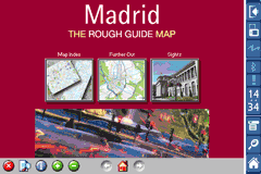
Rough Guides Map Madrid... These guides are a series of fantastic interactive maps.
Produced in conjunction with the premier travel publisher Rough Guides.
Discover and explore Madrid using full colour interactive linked maps, in this simple to use PDA version of The Rough Guides Madrid.
Find all the top tourist spots and key attractions with ease, information on the city and its sights can be quickly displayed with links to photographs and map locations. All in a superb easy to use interface.
If you''re travelling to Madrid, be sure you don''t leave home without this guide on your PDA.
The Rough Guide city maps includes:
Fully scrollable and interactive maps of the city.
Tap any location to display information and available links.
Intuitive navigation bar meaning you are never more than one click away from the information you require.
Map links allow you to directly link to other maps, photographs, or detailed views.
Categorised Find feature allowing you to quickly find any street, place of interest or station.
Categorised Information feature providing a wealth of information on the city, places of interest, etc.
1-Click Home feature, keeping the Home map always at hand.
Zoom function on all maps.
Hi Res & landscape displays supported.
Like it? Share with your friends!
If you got an error while installing Themes, Software or Games, please, read FAQ.
Supported operating systems:
Pocket PC 2002, Windows Mobile 2003, Windows Mobile 5.0, Windows Mobile 6 Classic, Windows Mobile 6 Professional, Windows Mobile 6.1 Classic, Windows Mobile 6.1 Professional, Windows Mobile 6.5 Professional
Similar Software:
Rough Guides Map Dublin Rough Guides Map Dublin... These guides are a series of fantastic interactive maps.
Produced in conjunction with the premier travel publisher Rough Guides.
Discover and explore Dublin using full colour interactive linked maps, in this simple to use PDA version of The Rough Guides Dublin
Map of Nepal Map of Nepal - A map of Nepal. Good for intercity travels with SmartMap.
Layers include:
Towns
Settlements
Airports
Roads
Railroads
Rivers
Inland water
Administrative borders
International borders
Trees
Map scale is 1:1 million.
Good for use with any version of SmartMap. SmartMap can be purchased here
Map of Athens / Greece for City Advisor Map of Athens / Greece for City Advisor
Instructions:
1. Download the map (zip file)
2. Extract the files in /CityAdvisor/maps
3. Open CityAdvisor -> Maps icon -> Menu -> Refresh
4
Traffic Vizzion Traffic Vizzion - IMPORTANT: Do not operate this product while driving; park the vehicle first. It is your sole responsibility to place, secure and use your mobile device in a manner that ensures safe driving
Tube 2 Engine Pocket PC Tube 2 Engine - Transform your PDA into a fully scrollable detailed map of one of the worlds subway or metro systems.
See your journeys come alive with a superb animated display.
Save hours by automatically having the quickest routes to hand, with all the details you need including line changes, platform directions and accurate journey times
Map of South Korea Map of South Korea - A map of South Korea. Good for intercity travels with SmartMap.
Layers include:
Towns
Settlements
Airports
Roads
Railroads
Rivers
Inland water
Administrative borders
International borders
Trees
Map scale is 1:1 million.
Good for use with any version of SmartMap
MyGPS PDA MyGPS_PDA - a light version of MyGPS software for Pocket PC systems. It reads the NMEA sentences coming from a GPS device connected to the Pocket PC and shows your position on a calibrated map. A calibrated map can be generated using MyGPS for PC and starting from any raster image file (.bmp, .jpg, .gif). MyGPS_PDA requires the Ewe VM installed on the Pocket PC
Google Maps Mobile WM Street View on your phone, as well as business reviews and walking directions
Take the power of Google Maps with you on your mobile phone.
Real-time traffic — See where the congestion is, and estimate delays in over 30 major US metropolitan areas
Map of Wyoming (US State) Map of Wyoming (US State) - A map of the Wyoming by VITO Technology. Good for intercity travels with SmartMap.
SmartMap is a mobile device application which uses vector and raster maps. It is compatible with any NMEA protocol GPS receiver (Compact Flash socket, serial port, BlueTooth or sleeve)
Map of South Dakota (US State) Map of South Dakota (US State) - A map of the South Dakota by VITO Technology. Good for intercity travels with SmartMap.
SmartMap is a mobile device application which uses vector and raster maps. It is compatible with any NMEA protocol GPS receiver (Compact Flash socket, serial port, BlueTooth or sleeve)
Other Software by developer «Visual IT»:
Boston Subway by Zuti Boston Subway by Zuti - The new Boston Subway map makes it easy to travel in and around the city using the MBTA Subway, MBTA Commuter Rail, MBTA Boats, and Massport shuttle buses
London Underground for iPad by Zuti London Underground for iPad by Zuti - "London Underground 10" is a superb map and route planner for the London Underground, Overground and Docklands Light Railway (DLR) services. So you can make a quick exit when you leave the train we have now added exit information for all stations on the London Underground
Tube 2 Chicago Pro (UIQ3) Tube 2 Chicago Pro (UIQ3) - This map package for Tube 2 consists of a fully scrollable detailed map of the Chicago metro & commuter rail system and linked street maps of central Chicago.
Plan journeys on the metro system, list details of the quickest routes and see a superb animated display of your journey tracking around the system map
Tube 2 Munich (Palm OS) Tube 2 Munich (Palm OS) - This map package for Tube 2 consists of a fully scrollable detailed map of the Munich metro, rail & tram system.
Plan journeys on this system, list details of the quickest routes and see a superb animated display of your journey tracking around the system map.
Munich is the capital city of Bavaria, the southern most German federal state
Tube 2 Los Angeles (UIQ) Tube 2 Los Angeles (UIQ) - This map package for Tube 2 consists of a fully scrollable detailed map of the Los Angeles rail system.
Plan journeys on this system, list details of the quickest routes and see a superb animated display of your journey tracking around the system map
Tube 2 Amsterdam (Palm OS) Tube 2 Amsterdam (Palm OS) - This map package for Tube 2 consists of a fully scrollable detailed map of the Amsterdam tram & metro system.
Plan journeys on this system, list details of the quickest routes and see a superb animated display of your journey tracking around the system map
Tube Singapore (Series 60) Tube Singapore (Series 60) - Our highly acclaimed Tube application that guides you around the metro system of Singapore is now available for your Series 60 Symbian powered phone. An essential addition to your phone for locals and tourists alike.
· A detailed clear colour map of the Singapore metro system fully scrollable.
· Quick find station utility
Tube 2 Seoul (UIQ3) Tube 2 Seoul (UIQ3) - This map package for Tube 2 consists of a fully scrollable detailed map of the Seoul Metropolitan Subway system.
Plan journeys on this system, list details of the quickest routes and see a superb animated display of your journey tracking around the system map
New York Subway by Zuti New York Subway by Zuti - The "New York Subway" application is a superb geographically based map and route planner for the New York public transport systems
Madrid Metro by Zuti Madrid Metro by Zuti - The new Madrid Metro 10 map makes it easy to travel in and around the city using the the Metro, Renfe Rail and Metro Ligero Rail services. Unlike old fashioned schematic style maps this product contains a geographically accurate central area showing major streets, parks and places of interest etc, allowing the user to easily get their bearings


 Hi Res & landscape displays supported.


")
")


")
")
")
")
")
")

