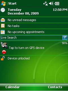
GPS2day is a today screen plug-in showing your current GPS coordinates, speed, satellite info, etc... Languages: English, Czech, Dutch, French, German, Hungarian, Italian, Japanese, Polish, Russian, Spanish.
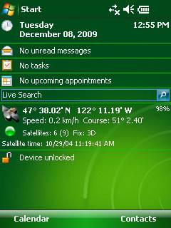
Currently GPS2day program works as GPS informer. It supports both metric and U.S. (Imperial) units and shows a various types of information for users, such as:
Current geographical coordinates (latitude, longitude);
Course and speed;
Some information about satellites and fix type;
Altitude followed by the fix 3D value;
Exact current date and time from the satellite atomic clock;
And battery life state which is important when you using GPS device.
What's New in This Release:
· Translation to Japanese was added
Like it? Share with your friends!
If you got an error while installing Themes, Software or Games, please, read FAQ.
Supported operating systems:
Windows Mobile 5.0, Windows Mobile 6 Classic, Windows Mobile 6 Professional, Windows Mobile 6.1 Classic, Windows Mobile 6.1 Professional, Windows Mobile 6.5 Professional
Similar Software:
FON Access Points for Palestinian Territory FON Access Points for Palestinian Territory - FON offers you a new Points of Interest service (POIs). This allows you to download FONspots directly to your navigation device.
What does that mean? You can download a Points of Interest file directly to your navigation device
FON Access Points for Thailand FON Access Points for Thailand - FON offers you a new Points of Interest service (POIs). This allows you to download FONspots directly to your navigation device.
What does that mean? You can download a Points of Interest file directly to your navigation device
TravelAddresserer TravelAddresserer uses the GPS on your PocketPC to find your current latitude/ longitude/ speed/ altitude and Googles the Country/ Street address and allows you to view your position on a map from the Google.com maps service. You can customize the maps zoom, and type via the 'Options' in the toolbar
NoniGPSPlot NoniGPSPlot allows you to locate your position in relation to other GPS points and to see the journey you have made.
It may be used to find your starting place in a port after sailing, or the place where you start a walking or biking excursion, or even your car in a parking. Any place long as you know its GPS coordinates.
It stores the whole journey too
Where I Am Where I Am - a small program using GPS and copies the coordinates in clipboard or builds a link for map in Google pointing to where you are now and saves it into clipboard again. Later all you have to do is only send this link. After installation you have to go to the folder containing this program, open settings
GPS Tracka GPS Tracka - A lightweight GPS logging application for Windows Mobile 6. Logs to a GPX file which can then be used to geotag your photos or imported into other applications.
This application uses the GPS receiver on your Windows Mobile phone to log your coordinates to a log file at regular intervals
MapsAligner MapsAligner - MapsAligner allows you to download large maps based on your GPS or with custom latitude and longitude points that you enter. You can use this to compose maps for your GPS applications. The program uses the Google.com maps server for the maps.
This program requires that you have both the 'BeanDLL
Nova Golf - Platinum with GPS Nova Golf - Platinum Golf System with GPS-This product is superseded by SmartCaddie Pro with GPS
Thousands of courses, if your course is not there we will simply add it for you
12 players or more, special versions are available for leagues
Sunset GPS Logger Sunset GPS Logger-allows you to capture your activities (walking, running, cycling, snowboarding, hiking trails .etc) for later visualisation on Google maps. Combined with your existing digital camera it becomes an indispensable tool to simplify the process of geo-tagging those precious photos and memories
BackCountry Navigator BackCountry Navigator is fun-filled navigation software for the outdoor adventurer. Use it in a variety of outdoor adventures, from kayak touring to geocaching. This is a summary of what you can do with the product.
BackCountry uses free topo and aerial maps for the United States, downloaded directly from Terraserver-USA
Other Software by developer «Soft Expanse Group»:
ShellSwitcher ShellSwitcher was implemented as a Windows Mobile system utility for fast switching between well known shells: Spb Mobile Shell, Titanium (WM6.5 default shell), Touch Flo 3D, HTC Sense and classic Today screen. This application is based on UI Switcher knowledge with some additional features