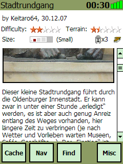
Cachebox is a geocache database for Windows Mobile devices. To use it you need GPX files available from geocaching.com
· Optimized for touch displays and fingertips, so leave your stylus where it belongs!
· You don't have a mobile internet connection? Fetch all data you need and store it on your device!
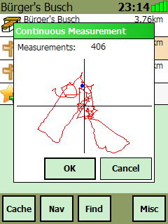
· Handles large amounts of data. Import any cache in your target area and browse caches on the go!
· Creates Garmin-compliant field notes which you can upload to geocaching.com!
· Supports additional waypoints
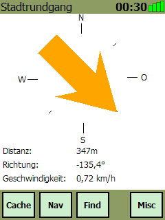
· Approach waypoints by using a map, compass or radar for the last few meters!
· View logs and decode hints!
· Imports GPX files generated by geocaching.com, opencaching.de and GSAK
· Spoiler Sync integration
Like it? Share with your friends!
If you got an error while installing Themes, Software or Games, please, read FAQ.
Supported operating systems:
Windows Mobile 5.0, Windows Mobile 6 Classic, Windows Mobile 6 Professional, Windows Mobile 6.1 Classic, Windows Mobile 6.1 Professional, Windows Mobile 6.5 Professional
Similar Software:
MapGoogler MapGoogler uses the GPS on your PocketPC to find your current latitude/longitude/speed and altitude and allows you to view your position on a map from the Google.com maps service. You can customize the maps zoom, and type via the 'Options' in the toolbar. The maps service is provided by Google
GpsSpeed Very simple program which calculates the speed using the GPS receiver
Psiloc TinyGPS Psiloc TinyGPS enables receiving information about location of your phone in your GSM network. It also shows name of your current location (if your GSM operator provides it).
You can teach your phone locations which are important for you like: home, school, work, train station, church etc. Then you can set up events based on entering or leaving chosen location
MyGPS_PDA MyGPS_PDA - MyGPS_PDA is a light MyGPS version for PocketPC systems. It reads the NMEA sentences coming from a GPS antenna connected to the PocketPC and shows your position on a MyGPS calibrated map. The program can also store on a file the track log together with specific waypoints created by the user
GPS Logger 2005 GPS Logger 2005 - Automatically record trip data over days or weeks. Make detailed surveys of topographical features, GIS, boundaries, street furniture, boreholes or any other element for which you wish to store location data. Plot it to CAD or any popular mapping application to produce easy to read graphical representations of your work
GPS Converter GPS Converter for Garmin, iGo, SpeedNavi and Powermap
Gpx2bin Gpx2bin - Gpx2bin is a GPS track converter software for Windows Mobile.
It can be used to convert .gpx, .mps, .plt and .nmea formats to the tracks.bin file used by Navitel Navigator to see the track as "blue line."
What's New in This Release:
· A problem with large files opening was fixed
GridHIKER GridHIKER-software for handheld units. A step further than raw numeric coordinates.
Recommended for paper map enthusiasts requiring determining his position. GridHIKER shows position graphically on usual Geographic grid or UTM grid which should be drown on paper map.
Features:
- Displaying Geographical grid for position between Lattitude -80S and 84N
CyberTracker 3 CyberTracker 3 - Capture data in the field using our unique icon-based user interface and a GPS for georeferencing. Analysis of the results can be done either in CyberTracker or exported to a third party program. Requires PocketPC 2002/2003/WM5+ or Palm 3 and higher
BikeTrack BikeTrack - This application enables everybody (who got your user/pass) look up your location on the net, using your the page http://fiets.galway.nl/ and keeps track of you.
On the webpage you can also create a username so you can use the software.
What it does:
- Gets location from GPS.
- Sends it to BikeTrack Server
Other Software by developer «getcachebox.net»:
not found
Comments on Cachebox:
Comments not found
If you noted an error or download link is broken, please, report it via this page or use comments.