mdNavMobile is a waypoint-based GPS navigation solution for the Windows Mobile platform. It can guide you from waypoint to waypoint while keeping you informed of all relevant navigation data. All NMEA-data from a GPS is automatically logged to file so you can 'replay' a trip with variable speed.
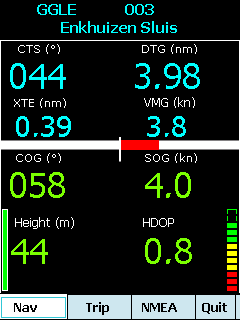
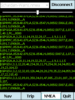
· GPS info: Latitude, Longitude, COG, SOG, Height, Satellites, HDOP and NMEA-stream
· Waypoint info: CTS, DTG, TTG, VMG, XTE
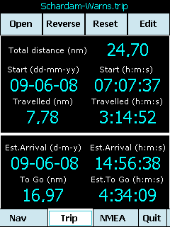
· Trip info: Total distance, Start, Travelled distance/time, DTG, TTG, ETA
· Reverse and Reset trips
· Scroll to next/previous waypoint
· Logs full NMEA stream from GPS to Storage Card
· Simulation using NMEA-log files with variable speed (factor 0.01-100)
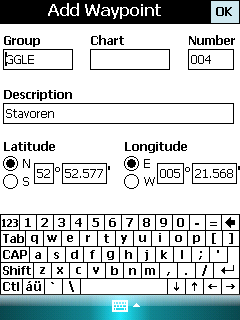
· Create/Edit Trips and Waypoints
· Show data in nm/kts/ft or km/kmh/m
· Change colors
· Trip-files also editable with notepad
· Totally free
Like it? Share with your friends!
If you got an error while installing Themes, Software or Games, please, read FAQ.
Supported operating systems:
Windows Mobile 5.0, Windows Mobile 6 Classic, Windows Mobile 6 Professional, Windows Mobile 6.1 Classic, Windows Mobile 6.1 Professional, Windows Mobile 6.5 Professional
Similar Software:
NoniGPSPlot NoniGPSPlot allows you to locate your position in relation to other GPS points and to see the journey you have made.
It may be used to find your starting place in a port after sailing, or the place where you start a walking or biking excursion, or even your car in a parking. Any place long as you know its GPS coordinates.
It stores the whole journey too
BlueWave GPS Displays GPS navigational information for boating
FON Access Points for Guernsey FON Access Points for Guernsey - FON offers you a new Points of Interest service (POIs). This allows you to download FONspots directly to your navigation device.
What does that mean? You can download a Points of Interest file directly to your navigation device
MapNameds MapNameds allows you to download and name GEO tagged maps. When you get a GPS lock select 'New Map' to download a map of your current location and enter the location name. The maps are tagged with the GPS of the location. This service is provided by Google
HandGPS HandGPS is provided for use with Windows PPC only. All versions of windows PPC are supported. Users are prompted to register product before use. License is valid for two years and may be extended. HandGPS is used to capture GPS coordinates to any open windows PPC application
RoadMap RoadMap - RoadMap is a car navigation system. RoadMap displays a map of the streets, tracks the position provided by a NMEA-compliant GPS receiver, identifies the street matching this GPS position and announces the name of the crossing street at the next intersection
Navigation BE-ON-ROAD USA Q2/2011 Navigation BE-ON-ROAD USA Q2/2011 - The new major version of be-on-road presents new features and is based on new platform which brings high level of reliability, portability and speed on almost any kind of device. The new be-on-road brings high value voice guided door-to-door navigation
TravelAddresserer TravelAddresserer uses the GPS on your PocketPC to find your current latitude/ longitude/ speed/ altitude and Googles the Country/ Street address and allows you to view your position on a map from the Google.com maps service. You can customize the maps zoom, and type via the 'Options' in the toolbar
FON Access Points for Guadaloupe FON Access Points for Guadaloupe - FON offers you a new Points of Interest service (POIs). This allows you to download FONspots directly to your navigation device.
What does that mean? You can download a Points of Interest file directly to your navigation device
FON Access Points for Vietnam FON Access Points for Vietnam - FON offers you a new Points of Interest service (POIs). This allows you to download FONspots directly to your navigation device.
What does that mean? You can download a Points of Interest file directly to your navigation device
Other Software by developer «Maurits Dijkens»:
not found
Comments on mdNavMobile:
Comments not found
If you noted an error or download link is broken, please, report it via this page or use comments.
mdNavMobile is compatible with your device Qtek 9600