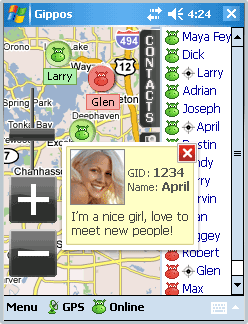
Gippos is mobile software for locating yourself and other users on the map and for instant messaging. Feel the city pace
Do you like to meet new people on the streets? Chat with them for free? Know where your friends are?
Meet and communicate without trouble! Enjoy nature
Arranging a picnic in a beautiful place? Inviting your friends for a country walk? Your friends will easily find you on a map!
· Find your friends on a map
· Meet new people around you
· Chat for free
What's New in This Release:
· Jabber protocol is used for messaging now.
· Jabber users from other servers can be added to contact list.
· Loading last messages to chat log window is added.
· Chat history viewing is added.
· Avatar loading is added.
· "About Gippos" info window is added.
· Maps switching logic is improved.
· Three modes of user's location visibility are implemented.
· New chat statuses are added.
· Gippos auto updating at new version release is added.
· "Don't turn the device off while the application is running" feature is implemented.
· Viewing user's location, history, and profile from chat window is added.
· Manually locating oneself on the map is added.
· Search window interface is changed
Like it? Share with your friends!
If you got an error while installing Themes, Software or Games, please, read FAQ.
Supported operating systems:
Windows Mobile 5.0, Windows Mobile 6 Classic, Windows Mobile 6 Professional, Windows Mobile 6.1 Classic, Windows Mobile 6.1 Professional, Windows Mobile 6.5 Professional
Similar Software:
AIS2OZI AIS2OZI - AIS2OZI tracks ship positions. It is a logger/decoder/plotter for PocketPC.
Ship positions are plotted directly in OziExplorer Download AIS2OZI (Make backup of Shiplist.txt when reinstalling.)
Decodes AIVDM sentences of types 1, 2, 3 and 5, i.e. position reports for class A shipborne equipment plus vessel information
PoliceGPSings PoliceGPSings - PoliceGPSings can be used by a Police officer to create dated GPS POI based note logs. For each GPS area you can create a log of reports from the area. The program uses the GPS on the PocketPC to find the distance of each GPS POI point and you can view or download the map the points on Google.com map service
GPS Tuner Essentials Full Version with Italy and Malta Basic Map Content GPS Tuner Essentials Full Version with Italy and Malta Basic Map Content is designed specifically for off-road use: its large buttons, selectable tool window size, multiple Compass views and the built-in Tele Atlas map makes it extremely user-friendly and reliable
FON Access Points for Malaysia FON Access Points for Malaysia - FON offers you a new Points of Interest service (POIs). This allows you to download FONspots directly to your navigation device.
What does that mean? You can download a Points of Interest file directly to your navigation device
H1N1 Pandemy Flu Alert This program recognizes your current location, from GPS Receiver, download the registered flu cases from the Internet database, and in case the closest flu was near your location, it will alert you by red screen and special sounds
Smart Runner Smart Runner - This application is aimed at people wanting to take up running but who need help sticking to the run/walk system. This system builds up your ability to run for long periods by swtiching between running and walking at regular intervals, e.g. run for 2 minutes. walk for 1 minute
TwitterGPSer TwitterGPSer uses the GPS on your PocketPC to find your current latitude/longitude/speed and allows you to update Twitter.com. Tap the button to get the GPS lock and when the program gets the lock it will create a Tweet with a Google.com map link. This service is provided by Twitter
bLADE Locate bLADE Locate - A Fire Eagle client for Windows Mobile
FON Access Points for Cyprus FON Access Points for Cyprus - FON offers you a new Points of Interest service (POIs). This allows you to download FONspots directly to your navigation device.
What does that mean? You can download a Points of Interest file directly to your navigation device
GPSSateliter GPSSateliter displays the GPS satellite listings and strength as a graph. When you tap the 'Start GPS' button the program will look for GPS satellites and graphically display the decibel of each. The more bars the better your GPS coverage
Other Software by developer «Gippos»:
not found
Comments on Gippos:
Comments not found
If you noted an error or download link is broken, please, report it via this page or use comments.