GPS data pusher, the current geographic position can be send in a special SMS message
Navigation with turn by turn route guidance in 3D view, cost advantage - don''t need internet connection, don''t need a map
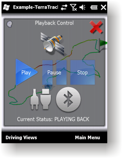
GPS simulator, playing back of recorded tracks
Route guidance in 3D view, makes navigation processes very simple and intuitive.
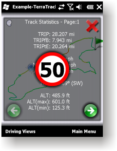
Recorded Track: Statistical analysis of track point information.
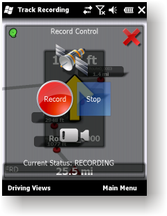
Track recording. Full NMEA-0183 format compatibility.
Playing back to your desktop PC''s NMEA-0183 Navigation software (Microsoft Streets and Trips 2010, Google Earth and many others). Virtual Serial Port (COM port) Driver for playing back at the same Windows phone.
Like it? Share with your friends!
If you got an error while installing Themes, Software or Games, please, read FAQ.
Supported operating systems:
Windows Mobile 2003, Windows Mobile 5.0, Windows Mobile 6 Classic, Windows Mobile 6 Professional, Windows Mobile 6.1 Classic, Windows Mobile 6.1 Professional, Windows Mobile 6.5 Professional
Similar Software:
Map of Nicaragua Map of Nicaragua - A map of the Nicaragua by VITO Technology. Good for intercity travels with SmartMap.
SmartMap is a mobile device application which uses vector and raster maps. It is compatible with any NMEA protocol GPS receiver (Compact Flash socket, serial port, BlueTooth or sleeve)
Travel Milan, Italy - illustrated travel guide, phrasebook, and maps Travel Milan, Italy - illustrated travel guide, phrasebook, and maps - An illustrated city guide, phrasebook, and maps. Indulge Yourself with a personal tour guide on Your PDA. FREE General Info, basic phrasebook and a map in the trial version.
Features
Fully illustrated.
Historical overviews.
Interesting facts
Map of Suriname Map of Suriname - A map of the Suriname by VITO Technology. Good for intercity travels with SmartMap.
SmartMap is a mobile device application which uses vector and raster maps. It is compatible with any NMEA protocol GPS receiver (Compact Flash socket, serial port, BlueTooth or sleeve)
Map of Spain Map of Spain - A map of Spain, divided into 8 smaller territories for the ease of use. Good for intercity travels with SmartMap.
Layers include:
Towns
Settlements
Airports
Roads
Railroads
Rivers
Inland water
Administrative borders
International borders
Trees
Map scale is 1:1 million
Map of Nevada (US State) Map of Nevada (US State) - A map of the Nevada by VITO Technology. Good for intercity travels with SmartMap.
SmartMap is a mobile device application which uses vector and raster maps. It is compatible with any NMEA protocol GPS receiver (Compact Flash socket, serial port, BlueTooth or sleeve)
redBANG Shenzhen 18 TOP SIGHTS 2006 THE BEST MOBILE GRAPHICS YOU HAVE EVER SET YOUR EYES ON
This TOP 18 sights map contains all THE TOP locations at your finger tips. Simple and easy to use multi step zoom in & out function map as well as movement in any direction
Map of Paraguay Map of Paraguay - A map of Paraguay. Good for intercity travels with SmartMap.
Layers include:
Towns
Settlements
Airports
Roads
Railroads
Rivers
Inland water
Administrative borders
International borders
Trees
Map scale is 1:1 million.
Good for use with any version of SmartMap. SmartMap can be purchased here
Map of Western Sahara Map of Western Sahara - A map of Western Sahara. Good for intercity travels with SmartMap.
Layers include:
Towns
Settlements
Airports
Roads
Railroads
Rivers
Inland water
Administrative borders
International borders
Trees
Map scale is 1:1 million.
Good for use with any version of SmartMap
KingMAP2 USA-New Jersey Electronic Map KingMAP2 USA-New Jersey Electronic Map is an Electronic Map Navigation Software exclusively for Pocket PC use; besides powerful functions provided for car navigation, it also comprises integrated Electronic Map functions with an abundant information database
Comments on TerraTrack Recorder 7:
Comments not found
If you noted an error or download link is broken, please, report it via this page or use comments.
TerraTrack Recorder 7 is compatible with your device Qtek S100


")


![USA-WA [Washington] Map for EagleEye PDA Tracking System](https://static.mobyware.org/data/images/def_program_reduced.png "USA-WA [Washington] Map for EagleEye PDA Tracking System")

