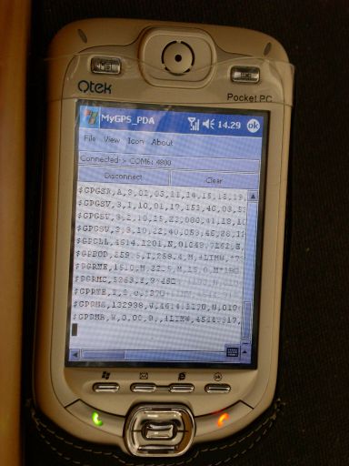
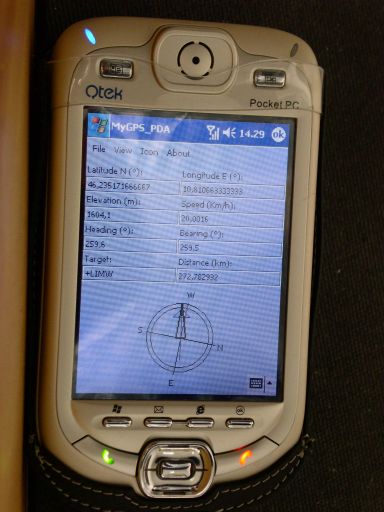
MyGPS_PDA - MyGPS_PDA is a light MyGPS version for PocketPC systems. It reads the NMEA sentences coming from a GPS antenna connected to the PocketPC and shows your position on a MyGPS calibrated map. The program can also store on a file the track log together with specific waypoints created by the user.
Like it? Share with your friends!
If you got an error while installing Themes, Software or Games, please, read FAQ.
Supported operating systems:
Windows Mobile 2003, Windows Mobile 5.0, Windows Mobile 6 Classic, Windows Mobile 6 Professional, Windows Mobile 6.1 Classic, Windows Mobile 6.1 Professional, Windows Mobile 6.5 Professional
Similar Software:
Navizon Navizon is a software application that will let you get your position, even if you don't have a GPS-enabled phone. Instead of using satellite signals like GPS does, it is triangulating signals from WiFi and Cellular towers. It is based on a collaborative database and the position of WiFi and Cell towers are provided by the users themselves
PocketReperion PocketReperion is Windows Mobile Software that brings you instant live GPS Tracking in Google Earth, Virtual Earth and Google Maps.
The client can upload your GPS positions to our server every 10 seconds or more. You can configure the minimal distance that you should move before an update is sent
Q-GPS Q-GPS - Q-GPS is a replacement for the built-in software A-GPS of the hw6515. A-GPS improve the speed to login of the GPS by downloading information on the net. Q-GPS make it possible to do the same, both for 2 and for 4 days. It does''nt use the same layer than HP firmware and avoid downloading freeze, usual with bluit-in software
KingMAP2 USA-New Jersey Electronic Map KingMAP2 USA-New Jersey Electronic Map is an Electronic Map Navigation Software exclusively for Pocket PC use; besides powerful functions provided for car navigation, it also comprises integrated Electronic Map functions with an abundant information database
MyMotion MyMotion - GPS route recording and playback with customizable spoken feedback of speed, distance and time. Uses a moving map to show progress as well as textual output. Maps can be generated from Google Earth installed on a PC using a map creation tool. Allows user to record a route then load it up as a reference for live comparison the next time it is traversed
FON Access Points for Holy See (Vatican City State) FON Access Points for Holy See (Vatican City State) - FON offers you a new Points of Interest service (POIs). This allows you to download FONspots directly to your navigation device.
What does that mean? You can download a Points of Interest file directly to your navigation device
FON Access Points for El Salvador FON Access Points for El Salvador - FON offers you a new Points of Interest service (POIs). This allows you to download FONspots directly to your navigation device.
What does that mean? You can download a Points of Interest file directly to your navigation device
IndicatorSpeed IndicatorSpeed uses the GPS on your PocketPC to find your speed and displays it on the task bar of any running PocketPC application. Select Km/Miles or NM and tap the button to start the GPS. The program reports your GPS chip GPRMC speed (Very accurate)
MapZIPeds MapZIPeds allows you to enter US ZIP code and gets your current GPS and downloads a Google.com map with a route of the ZIP code to your current GPS. Enter the ZIP code and start the GPS to get the lock. When you get the lock tap the button to view/download the map. This service is provided by USZIP
Danger! App for notification of danger on the road
Other Software by developer «Paolo Faure Ragani, Pier Paolo Colombo»:
not found
Comments on MyGPS_PDA:
Comments not found
If you noted an error or download link is broken, please, report it via this page or use comments.
MyGPS_PDA is compatible with your device Qtek S100


")


