GPS data pusher, the current geographic position can be send in a special SMS message
Navigation with turn by turn route guidance in 3D view, cost advantage - don''t need internet connection, don''t need a map
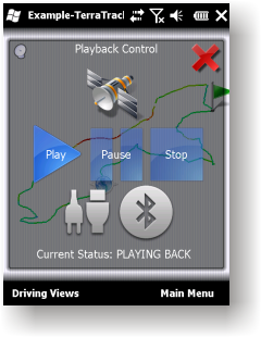
GPS simulator, playing back of recorded tracks
Route guidance in 3D view, makes navigation processes very simple and intuitive.
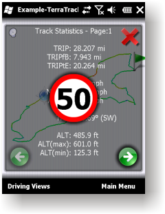
Recorded Track: Statistical analysis of track point information.
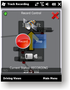
Track recording. Full NMEA-0183 format compatibility.
Playing back to your desktop PC''s NMEA-0183 Navigation software (Microsoft Streets and Trips 2010, Google Earth and many others). Virtual Serial Port (COM port) Driver for playing back at the same Windows phone.
Like it? Share with your friends!
If you got an error while installing Themes, Software or Games, please, read FAQ.
Supported operating systems:
Windows Mobile 2003, Windows Mobile 5.0, Windows Mobile 6 Classic, Windows Mobile 6 Professional, Windows Mobile 6.1 Classic, Windows Mobile 6.1 Professional, Windows Mobile 6.5 Professional
Similar Software:
Map of South Korea Map of South Korea - A map of South Korea. Good for intercity travels with SmartMap.
Layers include:
Towns
Settlements
Airports
Roads
Railroads
Rivers
Inland water
Administrative borders
International borders
Trees
Map scale is 1:1 million.
Good for use with any version of SmartMap
Map of Milan / Italy for City Advisor Milan / Italy map for City Advisor. Includes all tube lines, all urban trains lines, all tramway lines, all bus lines and supports full timetables.
Instructions:
1. Download the map (zip file)
2. Extract the files in /CityAdvisor/maps
3. Open CityAdvisor -> Maps icon -> Menu -> Refresh
4
Rough Guides Map London Rough Guides Map London... These guides are a series of fantastic interactive maps.
Produced in conjunction with the premier travel publisher Rough Guides.
Discover and explore London using full colour interactive linked maps, in this simple to use PDA version of The Rough Guides London
Paris Map Paris Map - Full map solution for Paris
View map:Display map,select objects,zoom,pan,...
Search: Search street,location,..by name
Shortest path: Show shortest path and total distance.
GPS: Connect to GPS device by bluetooth,go to location on map
Map of Slovakia Map of Slovakia - A map of Slovakia, divided into 4 smaller territories for the ease of use.
BRATISLAVA
ZAPADOSLOVENSKY
STREDOSLOVENSKY
VYCHODOSLOVENSKY
Good for intercity travels with SmartMap
Map of United Arab Emirates Map of United Arab Emirates - A map of United Arab Emirates, divided into 7 smaller territories for the ease of use.
ABU ZABY
DUBAI
ASH SHARIQAH
'AJMAN
UMM AL QAYWAYN
RA'S AL KHAYMAH
AL FUJAYRAH
Good for intercity travels with SmartMap
Map of Netherlands Map of Netherlands - A map of the Netherlands. Good for intercity travels with SmartMap.
Layers include:
Towns
Settlements
Airports
Roads
Railroads
Rivers
Inland water
Administrative borders
International borders
Trees
Map scale is 1:1 million.
Good for use with any version of SmartMap
MetrO (PPC) Metro helps you find your way in the public transport systems (subway, bus, trams, ...) in more than 4000 cities around the world. FREE, FAST & ACCURATE. Simply enter you start and end stops, hit the "Go" button and the program finds the fastest route
Map of Hanoi Capital city of Vietnam map. Handmap data file
MapKing 2007 Bangalore PPC Map in English MapKing 2007 Bangalore PPC Map in English - MapKing 2007 New Functions: More different profile Compass mode Open Tour book (need to connect to pc to edit) Support VGA monitor Nine intelligent map query (index/Crossing/ Q-find/POI/ position/City/Town/ Lat/Long/Keyword) Customer Support will not be provided for trial version
Comments on TerraTrack Recorder 7:
Comments not found
If you noted an error or download link is broken, please, report it via this page or use comments.
TerraTrack Recorder 7 is compatible with your device Qtek S110


")

