amAze (BlackBerry) is a first of its kind free navigation and local search service. It is free to download and use and it contains wide coverage of maps including aerial photo in Europe, North America, Australia and parts of Asia and Africa.
With amAze you get all these options and more:
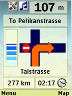
* Visual and voice guidance to any destination
* Search or define any location by its address
* Search and navigate to businesses listed in local search directories (where available)
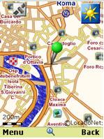
* Present any required location on the map
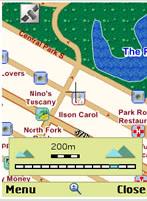
* View and use dynamic high quality maps at various scales
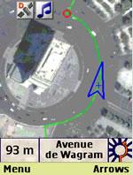
* View and navigate over high resolution satellite images
* Calculate the fastest way between two locations
* Save and manage personal favorites list
* Worldwide weather
amAze enables to calculate the route of a journey to any address or point of interest. Bluetooth connection with a GPS receiver will indicate your location along the route with vocal and graphical guidance to your destination in the shortest possible way. amAze is a collaborative effort led by LocatioNet Systems Ltd., together with some leading vendors in the fields of mapping, local search directories and other geographically related content.
Like it? Share with your friends!
Supported operating systems:
RIM BlackBerry OS 4.5, RIM BlackBerry OS 4.6, RIM BlackBerry OS 4.7, RIM BlackBerry OS 5.0, RIM BlackBerry OS 6.0
Similar Software:
MetrO (BlackBerry) Métro is your free guide to public transport systems worldwide (about 400 cities covered now)
Super Duper Survey Super Duper Survey is an easy to use application to take and report surveys. It's designed as a self contained, offline application perfect for street surveys
BigTinCan Mapper BigTinCan Mapper- Mapper is a cool app that let you take part in the global OSM community and "map your world" by adding Points of Interest (POIs) easily and quickly from a smartphone whenever and wherever you are
Travel Denmark Travel Denmark- An illustrated travel guide, phrasebook, and maps. Indulge Yourself with a personal tour guide on Your PDA. FREE General Information, basic phrasebook, and a map in the trial version.
Features
Fully illustrated.
Historical overviews.
Interesting facts.
City Attractions.
Phrasebook
Landmark maps, Street maps, and more
iCaller Location iCaller Location is a freeware application for Blackberry Smartphone. iCallerLocation shows the area code, city, and state of the incoming caller (United States only) and pinpoints the location on the Blackberry Maps. You will know where the call is coming from within the United States (will cover all cities in North America in the future)
J2ME OGC WMS Client J2ME OGC WMS Client is a program for accessing OGC Web map services from Java enabled mobile phone or PDAs.
It accesses the OGC WMS according to WMS 1.1.0 and 1.1.1 specifications and supports zooming and panning in the Map, WMS sublayers, and a bookmark management system for quick access.
Free for non-commercial use
MindBerry 1.2.0 MindBerry 1.2.0 is a mind-mapping software for BlackBerry smartphones. It's the ideal software for organize your thoughts, manage information overload, increase your productivity and creativity. Capture and organize your ideas at any moment, do it visually with MindBerry
부산지하철 부산지하철 - This is a simple version of viewing subway maps of Seoul in Korea.
It will be kept updating more functionalities such as route finder, time table and other subway maps
Mundo Terpel Move around Colombia with this application
Garmap for Mobile Garmap for Mobile - Search, share and navigate! Garmap for Mobile is a free, proudly South African mobile navigation application with local search powered by Yellow Pages and Facebook /Twitter/SMS sharing
Other Software by developer «LocatioNet Systems Ltd.»:
amAze (Sanyo) First of its kind free navigation and local search service. It is free to download and use and it contains wide coverage of maps including aerial photo in Europe, North America, Australia and parts of Asia and Africa
amAze (Sony Ericsson) AmAze is a first of its kind free navigation and local search service. It is free to download and use and it contains wide coverage of maps including aerial photo in Europe, North America, Australia and parts of Asia and Africa
amAze GPS (iPhone/iPad) amAze GPS includes turn-by-turn voice guided navigation with worldwide street maps, full topographic map coverage of the USA and satellite imagery for 200 major cities around the world. Initial download includes a free license to view maps and search for POI around the world
amAze (Sony Ericsson) AmAze is a first of its kind free navigation and local search service. It is free to download and use and it contains wide coverage of maps including aerial photo in Europe, North America, Australia and parts of Asia and Africa
amAze (Motorola) AmAze is a first of its kind free navigation and local search service. It is free to download and use and it contains wide coverage of maps including aerial photo in Europe, North America, Australia and parts of Asia and Africa
amAze (Android) AmAze is a first of its kind free navigation and local search service. It is free to download and use and it contains wide coverage of maps including aerial photo in Europe, North America, Australia and parts of Asia and Africa
amAze (Motorola) AmAze is a first of its kind free navigation and local search service. It is free to download and use and it contains wide coverage of maps including aerial photo in Europe, North America, Australia and parts of Asia and Africa
amAze (Philips) First of its kind free navigation and local search service. It is free to download and use and it contains wide coverage of maps including aerial photo in Europe, North America, Australia and parts of Asia and Africa
amAze (LG) AmAze is a first of its kind free navigation and local search service. It is free to download and use and it contains wide coverage of maps including aerial photo in Europe, North America, Australia and parts of Asia and Africa
amAze (LG) AmAze is a first of its kind free navigation and local search service. It is free to download and use and it contains wide coverage of maps including aerial photo in Europe, North America, Australia and parts of Asia and Africa

")
")
")
")


")
")
")
")
")
")
")
")
")
")