GPS Find is an application for discovering and marking waypoints with your GPS enabled BlackBerry smartphone. GPS Find can be used as a geocaching tool, or it can be used on an adventure, using the waypoint manager to mark locations as you go.
The main features of GPS Find include:
• GPS based location, speed, heading, distance and bearing.
• Customizable main screen.
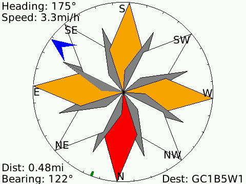
• A Wind Rose style Compass.
• A Waypoint manager.
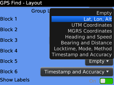
The Mainscreen has an adjustable font and layout allowing you to include only the blocks of information you want to see, in any order you wish. Currently the information groups that can be displayed include:
• Latitutde, Longitude, and Altitude
• UTM coordinates
• MGRS coordinates
• Heading and speed
• Bearing and distance
• Time-to-lock and GPS method.
• Timestamp and Accuracy
The Compass screen contains a windrose compass, and detailed information about speed, heading, and optionally distance and bearing when a destination has been set. When approaching the destination, a "Bullseye" screen is also available, showing a bird's-eye view of your location relative to the destination.
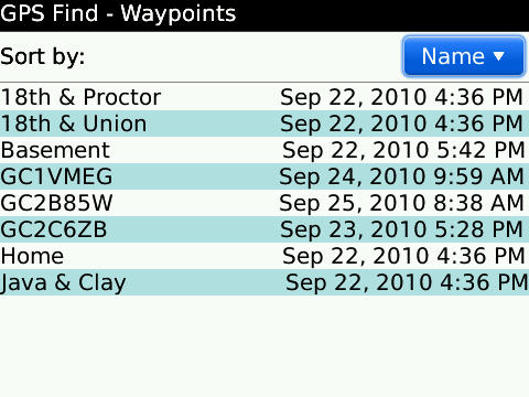
The Waypoint manager includes the following features:
• Import waypoints from .gpx, .loc and .kml files.
• Export waypoints to .gpx, and .kml files.
• Save current location and annotations.
• Manually enter location and annotations.
• Set any waypoint as destination (to compute bearing and distance).
• Map any waypoint using BlackBerry or Google Maps (subject to wireless signal availability)
• Send any waypoint in an e-mail, or write to memo.
Other features include:
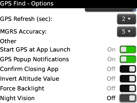
• Shows the number of satellites while gaining a coordinate fix.
• Force the backlight on while using GPS Find.
• Night mode (screens are red on black)
• Custom background colors and gradient.
• Automatic determination of magnetic north for current coordinates (based on NOAA/NGDC/BGS World Magnetic Model)
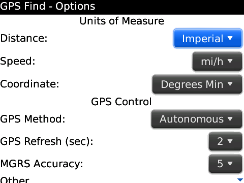
• Automatic adjustment of distance units
less than .1mi, units change to feet
less 1km, units change to meters
• When device is within 10 meters of destination, the handheld will display a popup message and vibrate.
· Trial version can be run 7 times.
What's New in This Release:
· Added methods for entering and editing coordinates in UTM and MGRS formats. Added map based location picker. Updates to night vision mode. Many bug fixes.
Like it? Share with your friends!
Supported operating systems:
RIM BlackBerry OS 4.6, RIM BlackBerry OS 4.7, RIM BlackBerry OS 5.0, RIM BlackBerry OS 6.0
Similar Software:
Btracking Turn your Handset into a GPS Tracker. BerryTracking is a simple API with powerful productivity features. A mobile management system that is based on GPS enabled Blackberry handsets for business or for personal use
Where Am I - GPS app Accurate GPS app , it will show you where you are: your country, region, city and street directly, quick and accurate. It is useful when your are in a strange place and wonder know your exact position
FON Access Points for Uruguai FON Access Points for Uruguai - FON offers you a new Points of Interest service (POIs). This allows you to download FONspots directly to your navigation device.
What does that mean? You can download a Points of Interest file directly to your navigation device
FON Access Points for San Marino FON Access Points for San Marino - FON offers you a new Points of Interest service (POIs). This allows you to download FONspots directly to your navigation device.
What does that mean? You can download a Points of Interest file directly to your navigation device
AKME Mobile Maps AKME Mobile Maps-is a GPS location-based mapping program for BlackBerry devices to geocode against maps stored on an SDCard in a tiled format, unlike network-dependent mapping programs from Google, Yahoo, and BlackBerry Maps
Jaccede Mobile Finding places easily accessible to people with disabilities just got easier with Jaccede mobile !
FON Access Points for Serbia and Montenegro FON Access Points for Serbia and Montenegro - FON offers you a new Points of Interest service (POIs). This allows you to download FONspots directly to your navigation device.
What does that mean? You can download a Points of Interest file directly to your navigation device
FreeCaddie FreeCaddie is a completely free golf rangefinder. The software runs on your phone and uses its GPS capabilities combined with course file data to tell your distance to the front, center and back of the green.
FreeCaddie is new but is growing rapidly. Don't see your golf course? Create a course file for it! It's easy and only takes a few minutes
FON Access Points for Ethiopia FON Access Points for Ethiopia - FON offers you a new Points of Interest service (POIs). This allows you to download FONspots directly to your navigation device.
What does that mean? You can download a Points of Interest file directly to your navigation device
Mobile Tracker+ Mobile Tracker+ helps you track your phone without draining your battery by giving the option of sending a start SMS trigger message to start sending phone’s location(Alerts) and sending a stop SMS keyword which will halt sending the phone’s location(Alerts)
Other Software by developer «Tworoads Software»:
CountDown Icon CountDown Icon - Count down the days and hours leading to an event with CountDown Icon. Track a wedding, vacation, Christmas or any event in the icon and application title on your homescreen.
Features:
Display the count of days, and last few hours to an event in the homescreen icon.
Insert an event from your calendar, and then edit as needed
MoonCal MoonCal is an application that allows you to view the lunar phase for any given date in graphical form, it also shows the name of the current phase and presents a table of the upcoming phases for the next month. MoonCal will also calculate equinoxes and solstices for the next year. Finally MoonCal will calculate the Chinese New Year, and associated information
Date Calc Date Calc calculates the date a given number of days in the past or the future, or the number of days between two dates. Date Calc can count calendar days or business days, including some common holidays (United States, Canada, Great Britian)
Location Notes Location Notes is a BlackBerry application which allows you to save GPS coordinates and notes or information about that place in a small database.
· Save notes and extended information along with GPS coordinates
HelioStat HelioStat is a BlackBerry application which allows you to determine the time and location of sunrise, sunset, moonrise, moonset, and lunar phase for any date and location you specify.
· Provides both the time, and azimuth of sunrise and sunset.
· Provides the time of civil, nautical and astronomical dawn and twilight
GPS Find GPS Find is an application for discovering and marking waypoints with your GPS enabled BlackBerry . GPS Find can be used as a geocaching tool, or it can be used on an adventure, using the waypoint manager to mark locations as you go.
The main features of GPS Find include:
• GPS based location, speed, heading, distance and bearing

")