GPS Status & Toolbox - Be a GEEK: Get the most out of your phone. Raw GPS data at your fingertips.
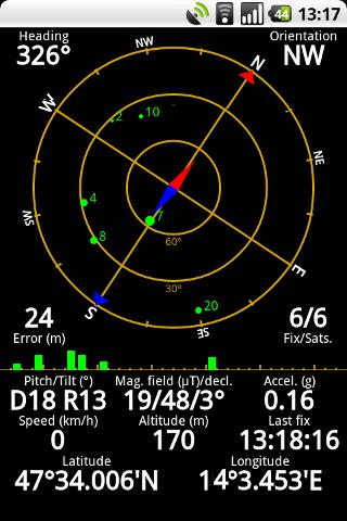
Display your GPS and sensor data: position and signal strength of satellites, accuracy, speed, acceleration, bearing.
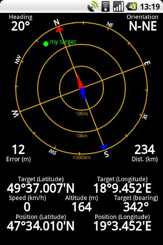
Tools included: compass with magnetic and true north, leveling tool, mark or share your location and navigate back later.
Keep your GPS fast: reset it or download A-GPS data regularly for faster fixes.
What's New in This Release:
· Workaround for Nexus S issues.
· aGPS age is correctly displayed (in hours / days).
· Fixed a rounding error in location formatting.
· More instruments for Nexus 7.
· Enhanced landscape layout. All instruments are available in landscape mode, too!
Like it? Share with your friends!
Supported operating systems:
Google Android 1.0, Google Android 1.5, Google Android 1.6, Google Android 10.x, Google Android 2.0, Google Android 2.1, Google Android 2.2, Google Android 2.3, Google Android 3.0, Google Android 3.1, Google Android 3.2, Google Android 4.0, Google Android 4.1, Google Android 4.2, Google Android 4.3, Google Android 4.4, Google Android 5.x, Google Android 6.x, Google Android 7.x, Google Android 8.x, Google Android 9.x
Similar Software:
InstaMapper (Android) InstaMapper is a free service that allows you to track a person or vehicle online in real time using a GPS-enabled mobile phone.
To use InstaMapper, you create a free account. Registration takes only a minute or two. All it is asked for is a username, password, and a valid email address.
Next, you install a small application on your GPS-enabled phone
Maverick Off-road GPS navigator with offline maps support, compass and track recording. Use offline maps and GPS even without an internet connection. This app is great for hiking, boating, geocaching and other outdoor activities
Geo note Geo note - is an organizing application for Android device users which takes into consideration your current location. When you are in a certain place your smartphone will remind you about coming event or task to complete
OpenSatNav OpenSatNav brings open-source satellite navigation to Android handsets.
· All code is open source.
· Global maps and navigation based on OpenStreetMap data
· Navigation by car, bicycle or by foot
TrekBuddy Trekbuddy is a J2ME application to be used with a GPS receiver. It is designed to work with every Java-enabled device. It features capabilities such as: * GPS tracking and simple navigation * bitmap maps (without zoom, you can store bitmap maps with different resolution instead)
GPS Odometer GPS Odometer - A simple and easy to use odometer. There is no maze of menus and no mysterious settings. GPS Odometer only does one thing, and does it well: measure distance traveled.
Note: Intended to measure relatively short distances, the application does not run in the background
amAze (Motorola) AmAze is a first of its kind free navigation and local search service. It is free to download and use and it contains wide coverage of maps including aerial photo in Europe, North America, Australia and parts of Asia and Africa
Location Manager Location Manager - This unique location app is best described with the following scenarios:
Scenario 1:
I live in an area where the Oregon, California, and Santa Fe Trails all passed through. There are signs everywhere saying, "The trails crossed here"
Other Software by developer «EclipSim Bt.»:
Hungarian for AnySoft Keyboard Kenyelmesen, magyarul irhat az Anysoft Keyboard segitsegevel. Magyar billentyűzet kiosztas es szotar AnySoftKeyboard-hoz. FIGYELEM! Ez egy kiegeszitő, ami csak az eredeti programmal egyutt műkodik. Onalloan nem!

")


")


")

