ViewRanger Outdoors GPS - ★★ with Global Open Sourced Maps★★
ViewRanger turns your Playbook into a fully featured Outdoors Navigation and Location Sharing device. Ideal for Hikers, Mountain Bikers and virtually any Off-Road activity.
ViewRanger lets you plan, plot, navigate, track, locate, record, analyse & share your outdoor adventures on a range of global web map layers like OpenStreetMap & OpenCycleMap.
In USA, Canada, UK, NZ and many other countries, it’s easy to upgrade to run premium topographic maps. (See our website to find out more).
The App comes with a free to join online outdoors community** - my.viewranger.com, which can be “sync'd” to your device. Create your own routes or utilize those posted by experts or the community. Upload your adventures and attach geotagged photo’s from Flickr or Picasa - ready to be stored, published to the community or shared via Facebook.
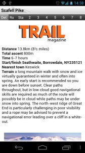
★★★★★ "Innovative software that transforms your phone or tablet." Trail
Magazine
★★★★★ Sunday Times “must have” app
★★★★★ Featured on Channel 5 Gadget Show
Used and trusted by search and rescue teams.
_______________________________________
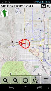
MAPS FOR ALL TERRAINS
✔Street and other mapping – choose between street, cycling and aerial imagery (global coverage)
✔Upgrade to full topo mapping in many countries
✔Works even without mobile coverage - as maps can be stored on your playbook(off-line)
✔Maps can be downloaded on the move**
✔Easy to read with Head-up and North-up view options.
_______________________________________
RECORD YOUR TRIPS
✔Clearly mark the path you've taken on the map in real-time.
✔Save the recorded path of all your trips
✔Upload your adventures to our online tool to share using Facebook or publish to the community
✔Create trip journals with photos from your Flickr™ or Picas*accounts
_______________________________________
ALL THE STATS YOU NEED
✔Real-time sport computer stats for over 30 metrics (i.e. speed, distance, time, elevation, pace, ETA, etc)
✔customise screen views in text, dial or graphical format
✔Real-time on-screen map co-ord display (UTM WGS84, NAD27, ITM, Lon/Lat, etc)
✔Supports imperial, nautical and metric units
_______________________________________
EASY TRIP PLANNING USING APP OR WEB
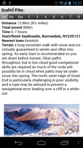
✔Download an expert guided route**
✔Create your own routes using the in-app tool or our online planner
✔Import a route as a GPX file
_______________________________________
FULL ON-SCREEN NAVIGATION
✔Active waypoint-based Navigation with on-screen visual guidance
✔Navigation alarms if you veer too far off track
______________________________________
LOCATION SHARING**
✔Share your real-time location with BuddyBeacon™ (a feature from ViewRanger)
✔See the mapped location of your friends on screen
✔Link your Twitter™ messages, photos and videos
_______________________________________
SEARCH & LOCATE
✔Search by Place name using online services.
✔Find location using map coordinate entry (ideal for Geocaching)
✔Real-time on-screen map coordinate display
✔Mark any important location as a Point of Interest (PoI)
Need more info: see our website: www.viewranger.com. Any questions or feedback, please drop us an e-mail: support@viewranger.com
Notes: * registration required, **may incur additional charges ***requires mobile data
Like it? Share with your friends!
Supported operating systems:
RIM BlackBerry PlayBook OS 2.0, RIM BlackBerry Tablet OS 1.0
Similar Software:
FON Access Points for India FON Access Points for India - FON offers you a new Points of Interest service (POIs). This allows you to download FONspots directly to your navigation device.
What does that mean? You can download a Points of Interest file directly to your navigation device
FON Access Points for Germany FON Access Points for Germany - FON offers you a new Points of Interest service (POIs). This allows you to download FONspots directly to your navigation device.
What does that mean? You can download a Points of Interest file directly to your navigation device
FON Access Points for Israel FON Access Points for Israel - FON offers you a new Points of Interest service (POIs). This allows you to download FONspots directly to your navigation device.
What does that mean? You can download a Points of Interest file directly to your navigation device
FON Access Points for French Polynesia FON Access Points for French Polynesia - FON offers you a new Points of Interest service (POIs). This allows you to download FONspots directly to your navigation device.
What does that mean? You can download a Points of Interest file directly to your navigation device
FON Access Points for Japan FON Access Points for Japan - FON offers you a new Points of Interest service (POIs). This allows you to download FONspots directly to your navigation device.
What does that mean? You can download a Points of Interest file directly to your navigation device
FON Access Points for France FON Access Points for France - FON offers you a new Points of Interest service (POIs). This allows you to download FONspots directly to your navigation device.
What does that mean? You can download a Points of Interest file directly to your navigation device
MyNino(Parent) for BlackBerry PlayBook MyNino(Parent) for BlackBerry PlayBook - Are you in search of a Mobile to Mobile Tracking, GPS Tracking, Cross Platform Tracking, or Child Tracking application? Than MyNiño is the right solution for you
FON Access Points for Ireland FON Access Points for Ireland - FON offers you a new Points of Interest service (POIs). This allows you to download FONspots directly to your navigation device.
What does that mean? You can download a Points of Interest file directly to your navigation device
FON Access Points for Italy FON Access Points for Italy - FON offers you a new Points of Interest service (POIs). This allows you to download FONspots directly to your navigation device.
What does that mean? You can download a Points of Interest file directly to your navigation device
FON Access Points for Honduras FON Access Points for Honduras - FON offers you a new Points of Interest service (POIs). This allows you to download FONspots directly to your navigation device.
What does that mean? You can download a Points of Interest file directly to your navigation device
Other Software by developer «Augmentra»:
not found
Comments on ViewRanger Outdoors GPS:
Comments not found
If you noted an error or download link is broken, please, report it via this page or use comments.
ViewRanger Outdoors GPS is compatible with your device RIM BlackBerry PlayBook


 for BlackBerry PlayBook")


