SmartGPX is a geocaching.com Pocket Query viewer for Symbian OS based phones. It is designed to be as simple as possible. You can hold your GPS receiver in one hand and your Symbian OS device in the other hand to view your location and the cache description at the same time. The actuals versions of SmartGPX are quite stable now and have a wide range of functionalities, that make Geocacher's life a bit easier.
· Read Pocket Queries in GPX format available for Premium Members at geocaching.com.
· Import GPX files from filesystem (phone memory on C: or memory card on E:).
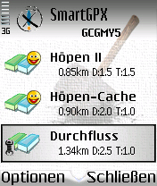
· Show all caches in an overview list with information about cache type, TB inside, found.
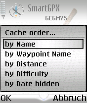
· Cache list order by name, waypoint name (GCxxxx), distance/direction, difficulty, date hidden, date of last log.
· Set filter for Geocache list (Filter by name, container, type, distance/direction, found/not found)
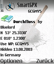
· Show cache description in a detail view as plain text and HTML with other information.
· Additional images for cache descriptions can be downloaded and displayed via network.
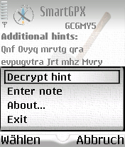
· Show hints encrypted and decrypted.
· Show logs entered for a cache.
· Show travelbugs contained in a cache
· Enter additional notes for caches.
· Set "Found it" flag for caches that have been found
· Cache finds can be added as notes to the device calendar
· Support for opencaching.de GPX files.
· S60: Export Geocaches to Landmark DB
· S60: Get current position from connected or built-in GPS receiver
· S60: Start navigation applications from within SmartGPX
· Spoiler Sync/Geopics.pl support
· Import of all GPX files from a directory
· Supported languages: English, German, Danish, Czech, Dutch, Polish, Finnish, Hungarian, Portugues, Swedish, Romanian, Catalan, Spanish, Afrikaans
What's New in This Release:
· Show cache attributes when available
· Fixed bug: Crash when loading caches with ' in the name
· Some other smaller things
Like it? Share with your friends!
If you got an error while installing Themes, Software or Games, please, read FAQ.
FON Access Points for Zambia FON Access Points for Zambia - FON offers you a new Points of Interest service (POIs). This allows you to download FONspots directly to your navigation device.
What does that mean? You can download a Points of Interest file directly to your navigation device
FON Access Points for Andorra FON Access Points for Andorra - FON offers you a new Points of Interest service (POIs). This allows you to download FONspots directly to your navigation device.
What does that mean? You can download a Points of Interest file directly to your navigation device
FON Access Points for Antarctica FON Access Points for Antarctica - FON offers you a new Points of Interest service (POIs). This allows you to download FONspots directly to your navigation device.
What does that mean? You can download a Points of Interest file directly to your navigation device
RSnavi The RSnavi navigation software is designed for determining location and orienteering with the help of data from the GPS receiver and the calculated position of the sun and the moon. The application runs on smartphones with Symbian OS. The nearest populate
· You can see your coordinates obtained from GPS together with speed and direction of the motion
CIA World Factbook 2009 CIA World Factbook 2009- - The CIA World Factbook is a reference resource produced by the Central Intelligence Agency of the United States with almanac-style information about the countries of the world. It provides a summary of the demographics, geography, communications, government, economy, and military of U.S
Nokia Maps 2 Nokia Maps puts free downloadable maps and routing from A to B in your hands. With free maps for more than 150 countries, and with 15 million points of interest pre-loaded, you can plan your route street by street, city to city
FON Access Points for New Zealand FON Access Points for New Zealand - FON offers you a new Points of Interest service (POIs). This allows you to download FONspots directly to your navigation device.
What does that mean? You can download a Points of Interest file directly to your navigation device
Telmap Navigator Telmap Navigator gives you full-featured navigation and guidance to where you want to go.
In-car navigation
Crystal clear Sat Nav
Telmap Navigator upgrades your mobile to a complete Sat Nav system that stays with you wherever you go
FON Access Points for Spain FON Access Points for Spain - FON offers you a new Points of Interest service (POIs). This allows you to download FONspots directly to your navigation device.
What does that mean? You can download a Points of Interest file directly to your navigation device
AnchorAlert AnchorAlert checks how far your vessel has drifted from its anchor point and sounds an alarm when the value exceeds the specified distance.
USAGE
Start the application, that will automatically connect to the predefined GPS (see Settings). You will see your latitude/longitude on the
main screen after GPS has a fix position
Other Software by developer «Dimitri Brukakis»:
Kfz-Kennzeichen Kfz-Kennzeichen can be used to find the name of a German city by the first letters of a car's license plate
Chords Chords - How many times have I sat in the rehearsal room trying to find the correct finger positions on my guitar's fretboard for a chord, that my keyboarder wanted me to play in a special bridge. Normally I don't have a chord book in my guitar case, but I never forget my mobile phone (for the pizza order, you know :-D). So why not use the phone in this case also
Mobile Weather S60 Mobile Weather - weather forecast client for S60 Smartphones that shows the current weather situation of hundreds of cities anywhere all around the world. It is available for Nokia S60 Second Edition (FP2 and FP3) and Third Edition devices. See the list of supported phones and which installation package is needed for your phone at the end of this page
U-Bahn Navigator U-Bahn Navigator helps you navigating through foreign public transport networks. It finds the shortest or direct route from a start to a destination station of the loaded subway map. U-Bahn Navigator is extensible to support each public transport network