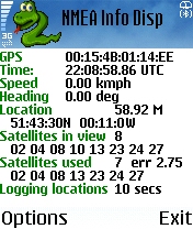
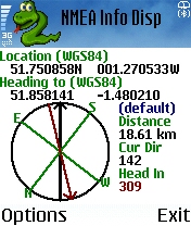
NMEA Info-A graphical Python program that talks to your GPS, and does useful things with the information. It is able to talk to a Bluetooth GPS (parsing the nmea data strea), or on S60 v3 phones with the LocationRequestor module, an internal GPS.
The program displays your current location, speed and heading, satellites in view, satellite signal strength, the time, distance and direction to a point, and more. It optionally also dumps positions to a file, which you can later get off to see where you went. It can take photos, and add the Geo Exif headers to tell you where you were when you took it (requires PExif). Can also log GSM location, for use with gsmloc.org.
Like it? Share with your friends!
If you got an error while installing Themes, Software or Games, please, read FAQ.
NorthPole NorthPole-is a small utility that will turn your E72 into an accurate compass. Application also provides full instructions to calibrate magnetometer for the most accurate result it can be
G-Meter G-Meter -
G-Meter uses the built in accelerometer sensor to measure the current value and direction of G-force acting on the mobile phone. It models a traditional analog instrument and therefore ensures simple handling and maximum readability
Magic Wand Magic Wand is an application for tourists, which makes exploring a foreign city easier. It enables the user to identify a sight without a tourist guide book, but by using the mobile phone. The tourist just has to hold the mobile phone in the direction of the sight to identify it. With a keystroke, the name of the sight is shown on the display
SMap SMap allows you to record and manage your running, hiking, cycling, MTB or sailing routes and easily upload them onto the Sanoodi website live via GPRS or later when you connect your mobile to your desktop computer.
· Two screens: a Pace Screen and a route Summary Screen
Kai's Ruler Generator (PC) Kai's Ruler Generator (PC) - With the Ruler Generator you can create a virtual ruler for almost every device or rather cellphone. For that your device must only be able to display a picture (jpg, bmp, png) in fullscreen mode. The Ruler Generator creates a picture with any desired pixel resolution and any cm/inch-graduation
Travel Light Free text multi-language translator, Currency (online updates), World Clock & Map (550+ cities) & Sun Compass, Tip split, Unit/dress convertor, Pack List
piPOI Alert piPOI Alert provides a POI warning system - Eg: speed cameras, constructions sides, gas stations, malls, restaurants...Basically it informs the user (visual + audio) when a POI gets close (in a defined area)
Sun Compass Sun Compass is a program to show the north direction from the sun or moon position. It also gives you the direction to Makkah.
There are two ways of use:
1. the north is at the top of your phone: hold it with direction of the red arrow to the sun or moon.
2. the sun or moon is on top of the phone: the red arrow gives you the north direction
Cam Measure - LITE Cam Measure - LITE - What can you do with your phone? Get your position, take photos and videos, your speed, comunicate with other devices... Now you can also measure the distance and heigth of objects near you! And this with a tollerance of only +/-5%!
All this is possible thanks to your phone acceleration sensors, your camera and your skill
Sun Compass Sun Compass - A program to show the north direction from the sun or moon position. It also give you the direction to Makkah. You may see the sun or the north direction on top.
There are two ways of use:
1. the north is at the top of your phone: hold it with direction of the arrow to the sun.
2. the sun is on top of the phone: the arrow gives you the north direction


")


