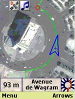
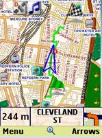
amAze (Philips) - amAze is a first of its kind free navigation and local search service. It is free to download and use and it contains wide coverage of maps including aerial photo in Europe, North America, Australia and parts of Asia and Africa.
With amAze you get all these options and more:
* Visual and voice guidance to any destination
* Search or define any location by its address
* Search and navigate to businesses listed in local search directories (where available)
* Present any required location on the map
* View and use dynamic high quality maps at various scales
* View and navigate over high resolution satellite images
* Calculate the fastest way between two locations
* Save and manage personal favorites list
* Worldwide weather
amAze enables to calculate the route of a journey to any address or point of interest. Bluetooth connection with a GPS receiver will indicate your location along the route with vocal and graphical guidance to your destination in the shortest possible way. amAze is a collaborative effort led by LocatioNet Systems Ltd., together with some leading vendors in the fields of mapping, local search directories and other geographically related content.
Like it? Share with your friends!
Supported operating systems:
Java ME, Java Nokia 240x320, Java SE 240x320
Similar Software:
GpsMid Germany, Rhein-Main (Giessen - Heidelberg) GpsMid Germany, Rhein-Main (Giessen - Heidelberg) is a free, fully offline, vector based map application for your mobile phone. It displays your current position on a zoomable map and can be used to search for and navigate to roads or points of interest of your liking
Earthcomber Earthcomber Busness Week calls it "the best locator app out there." And it's not just for travelers. You pick your favorite food, clubs, pubs, stores - your screen shows it. Automatically refreshing as you move.* Handy things like free WiFi, coffee places, ATMs, and late night delights
gvSIG Mini gvSIG Mini - : DEION :
gvSIG Mini is a free viewer of free access maps based on tiles (OpenStreetMap, YahooMaps, Microsoft Bing, ...), with a WMS, WMS-C client, address and POI search, routes, hybrid location and many more things. It runs with both on/off-line modes.
Main Features
1) Full list of Features available here
GpsMid Malta GpsMid is a free, fully offline, vector based map application for your mobile phone. It displays your current position on a zoomable map and can be used to search for and navigate to roads or points of interest of your liking. As all data is stored in a compact binary format on your mobile phone you will incur no charges for extra data downloads
Tube Map Tube Map - This is a copy of the well-known London Tube map in midlet form!
See my site for some more tube maps, some bus maps and an amazingly useful street map of London.:
http://sites.google
GpsMid USA, Bay Area GpsMid USA, Bay Area is a free, fully offline, vector based map application for your mobile phone. It displays your current position on a zoomable map and can be used to search for and navigate to roads or points of interest of your liking. As all data is stored in a compact binary format on your mobile phone you will incur no charges for extra data downloads
GpsMid United States (Colorado) GpsMid is a free, fully offline, vector based map application for your mobile phone. It displays your current position on a zoomable map and can be used to search for and navigate to roads or points of interest of your liking. As all data is stored in a compact binary format on your mobile phone you will incur no charges for extra data downloads
GpsMid Turkey GpsMid is a free, fully offline, vector based map application for your mobile phone. It displays your current position on a zoomable map and can be used to search for and navigate to roads or points of interest of your liking. As all data is stored in a compact binary format on your mobile phone you will incur no charges for extra data downloads
Other Software by developer «LocatioNet Systems Ltd.»:
amAze (Sonim) AmAze is a first of its kind free navigation and local search service. It is free to download and use and it contains wide coverage of maps including aerial photo in Europe, North America, Australia and parts of Asia and Africa
amAze (Motorola) AmAze is a first of its kind free navigation and local search service. It is free to download and use and it contains wide coverage of maps including aerial photo in Europe, North America, Australia and parts of Asia and Africa
amAze (Nokia) AmAze is a first of its kind free navigation and local search service. It is free to download and use and it contains wide coverage of maps including aerial photo in Europe, North America, Australia and parts of Asia and Africa
amAze (Windows Mobile) AmAze is a first of its kind free navigation and local search service. It is free to download and use and it contains wide coverage of maps including aerial photo in Europe, North America, Australia and parts of Asia and Africa
amAze (Samsung) AmAze is a first of its kind free navigation and local search service. It is free to download and use and it contains wide coverage of maps including aerial photo in Europe, North America, Australia and parts of Asia and Africa
amAze GPS (iPhone/iPad) amAze GPS includes turn-by-turn voice guided navigation with worldwide street maps, full topographic map coverage of the USA and satellite imagery for 200 major cities around the world. Initial download includes a free license to view maps and search for POI around the world
amAze (BlackBerry) AmAze is a first of its kind free navigation and local search service. It is free to download and use and it contains wide coverage of maps including aerial photo in Europe, North America, Australia and parts of Asia and Africa
amAze (Motorola) AmAze is a first of its kind free navigation and local search service. It is free to download and use and it contains wide coverage of maps including aerial photo in Europe, North America, Australia and parts of Asia and Africa
amAze (FLY) First of its kind free navigation and local search service. It is free to download and use and it contains wide coverage of maps including aerial photo in Europe, North America, Australia and parts of Asia and Africa


")
")
")


")

")
")
")
")
")
")
")
")
")