vlkGPS - Simple GPS navigation for mobile phones. Best for geocaching, walking, bicycle, sport, ...
show:
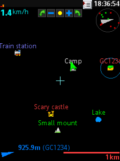
· coordinates (actual or cursor position)
· altitude
· speed
· zoom scale (10m - 10 000km)
· compass and satellites view
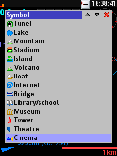
· waypoints (symbol and name)
· navigate to waypoint info (azimuth, heading, distance and name)
· satellite time
· last track + elevation and altitude profile
waypoints:
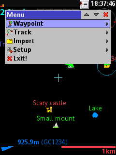
· saving
· listing (sort by distance from cursor)
· searching by keyword
· editing name and ident
· editing coordinates (entering coordinates is possible in some formats)
· editing altitude, proximity
· editing description, city, country
· chaning symbol
· text format (bold, big) and color
· deleting
· go to waypoint (move cursor to waypoint)
· navigate to waypoint
· export waypoint or all waypoints to bluetooth, phone memory, or to memory card in .csv,.gpx, .kml, .loc format
· import from phone memory and memory card in .csv, .kml, .gpx and .loc file format
track:
· recording
· deleting
· exporting to bluetooth, phone memory, or to memory card in .csv,.gpx, .kml format
· setting "compression" of saved track
other:
· support for touch screen
· units change: coordinates (D, DM, DMS), distance (m, km, mi, nm), height (m, km, ft), speed (km/h, m/s, mph, kt)
· localization (EN, SK, CZ, FR)
· color scheme for DAY and NIGHT
· enables to set backlight AUTO OFF or ALWAYS ON
· search (or direct enter MAC address of BT GPS), connect and disconnect GPS device
· on/off backlight hack on Sony Ericsson phones (make problems on some nokia phones)
license:
· free and not limited
What's New in This Release:
· Memory Leak in Menus fixed
· Add/Edit Waypoints now with save/cancel
· Sync with Cachecow overwrites
What's New in 0.9.6:
· Save all tracks into one file
· Security Exception in Export
· Minor Fixes
What's New in 0.9.4:
· Save all tracks into one file
· Security Exception in Export
· Minor Fixes
Like it? Share with your friends!
Requirements:· optimized for bluetooth enabled SonyEricsson mobile phones with minimum display resolution 176x220 pix
· supported SonyEricsson, Nokia, Motorola and Siemens phones
· external bluetooth, or internal GPS receive
Supported operating systems:
Java ME, Java Nokia 240x320, Java SE 240x320
Similar Software:
FON Access Points for USA FON Access Points for USA - FON offers you a new Points of Interest service (POIs). This allows you to download FONspots directly to your navigation device.
What does that mean? You can download a Points of Interest file directly to your navigation device
GpsMid Moldova GpsMid is a free, fully offline, vector based map application for your mobile phone. It displays your current position on a zoomable map and can be used to search for and navigate to roads or points of interest of your liking. As all data is stored in a compact binary format on your mobile phone you will incur no charges for extra data downloads
FON Access Points for Macao FON Access Points for Macao - FON offers you a new Points of Interest service (POIs). This allows you to download FONspots directly to your navigation device.
What does that mean? You can download a Points of Interest file directly to your navigation device
FON Access Points for Slovakia (Slovak Republic) FON Access Points for Slovakia (Slovak Republic) - FON offers you a new Points of Interest service (POIs). This allows you to download FONspots directly to your navigation device.
What does that mean? You can download a Points of Interest file directly to your navigation device
FON Access Points for Kuwait FON Access Points for Kuwait - FON offers you a new Points of Interest service (POIs). This allows you to download FONspots directly to your navigation device.
What does that mean? You can download a Points of Interest file directly to your navigation device
FON Access Points for Andorra FON Access Points for Andorra - FON offers you a new Points of Interest service (POIs). This allows you to download FONspots directly to your navigation device.
What does that mean? You can download a Points of Interest file directly to your navigation device
FON Access Points for Puerto Rico FON Access Points for Puerto Rico - FON offers you a new Points of Interest service (POIs). This allows you to download FONspots directly to your navigation device.
What does that mean? You can download a Points of Interest file directly to your navigation device
amAze (FLY) First of its kind free navigation and local search service. It is free to download and use and it contains wide coverage of maps including aerial photo in Europe, North America, Australia and parts of Asia and Africa
GpsMid Germany, Rhein-Main (Giessen - Heidelberg) GpsMid Germany, Rhein-Main (Giessen - Heidelberg) is a free, fully offline, vector based map application for your mobile phone. It displays your current position on a zoomable map and can be used to search for and navigate to roads or points of interest of your liking
Guidebee Map Guidebee Map - For commerical version, please visit Nokia Ovi store find "Guidebee Navigator" under city guides & maps. Mobile Map, GPS Compass, MSN Messenger, IP Search, Find address, Get Direction download link http://www.guidebee.biz/forum/viewthread
Other Software by developer «VLK»:
not found
Comments on vlkGPS:
Comments not found
If you noted an error or download link is broken, please, report it via this page or use comments.
vlkGPS is compatible with your device Samsung C3312 Rex 60


")


")
")
