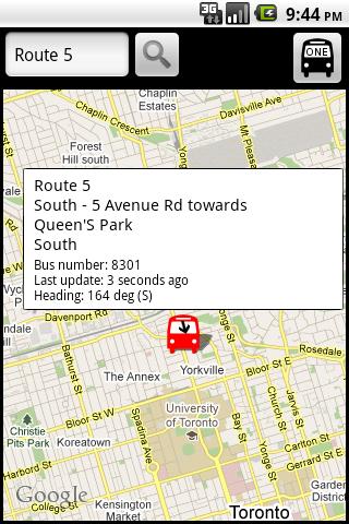
TorontoBusMap - TorontoBusMap shows locations and predicts bus times in Toronto using GPS info from the Toronto Transit Commission.
What's New in This Release:
· GPS now turns on when you start the app to allow quicker location lookup times. NOTE: There is also a new checkbox in the settings to disable this if you do not want it
· all stops mode added! This will show and update all bus stops around the center of the screen, not just ones on your current route. May be slow for older phones
· recently updated stops are temporarily colored green to show that they've updated
· search now searches stop titles in addition to routes
Like it? Share with your friends!
Supported operating systems:
Google Android 1.5, Google Android 1.6, Google Android 10.x, Google Android 2.0, Google Android 2.1, Google Android 2.2, Google Android 2.3, Google Android 3.0, Google Android 3.1, Google Android 3.2, Google Android 4.0, Google Android 4.1, Google Android 4.2, Google Android 4.3, Google Android 4.4, Google Android 5.x, Google Android 6.x, Google Android 7.x, Google Android 8.x, Google Android 9.x
Similar Software:
Metroid Metroid is an Android itinerary planning application meant to help users with public transportation systems worldwide. Metroid has been designed with extensibility in mind. It is able to support any public transportation system provided that the right map is available.
Metroid is based on maps
PNR Status Buzz PNR Status Buzz - We have created this PNR Stataus Buzz App to help out the passenger traveling across the nation. Mostly in India people travel through train as it is an affordable and convenient medium of traveling
Death Valley Traveller Death Valley Traveller - This is the source for news, events, weather, camping, lodging, fees, permits and facilities.
Find information about natural resources.
Read about the history.
Everything you ever wanted to know about Death Valley National Park
Journey Pro Journey Pro - The zoomable interactive maps of the Greater London, National Rail, and River Service let you set From/To stations to obtain route plans instantly. You can also find the nearest station/bus stop with a single tap. Tube departure boards and station facility information are available to facilitate your journey planning
Parkade App This app will help users get info about the nearest parkade
phoneHotel With phoneHotel from probasys it is easy to look for a hotel in the area of your travel destination or if you have GPS in your smartphone, in a given radius of your actual location. You get the hotel room rates and all other information available. You can choose a hotel and book it with a few clicks online from your mobile
Best Nightclubs World Best Nightclubs World - Find here a list of the World's Top Nightclubs.
Look here for the top nightlife cities you should visit for a good time
IATA / ICAO Dictionary IATA / ICAO Dictionary -This application is an offline database for IATA / ICAO airport, airline, aircraft, delay codes and aircraft registration codes
Fly Delta Fly Delta - Manage your travel on Delta with access to boarding passes, flight info & more.
Designed to make flying Delta Air Lines even more convenient and rewarding, this free travel app helps you take care of key travel tasks on the go:
- check in for upcoming flights.
- download mobile boarding passes (where available)
Citybike Stationen Wien Zeigt eine Liste der Wiener Citybike Stationen nach der Entfernung vom aktuellen Standort geordnet an. Fur jede Station ist die Anzahl der freien Rader, die Anzahl der freien Boxen, sowie der Standort ersichtlich. Bitte Hinweise unter Menu / About beachten (Beta Version)!
Other Software by developer «George Schneeloch»:
BostonBusMap BostonBusMap is an application for Android phones. It uses GPS data provided by the MBTA to plot the real-time location of buses on a map.
What's New in This Release:
· GPS now turns on when you start the app to allow quicker location lookup times
UMichBusMap An Android application which shows the live positions of University of Michigan buses overlayed on Google Maps
Los AngelBus Los AngelBus - This application shows locations and predicts bus times in Los Angeles using GPS info from the Los Angeles Metro.
What's New in This Release:
· GPS now turns on when you start the app to allow quicker location lookup times

")