Metro LX is a comprehensive guide to the Lisbon Subway providing:
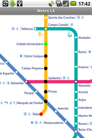
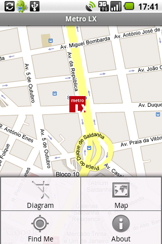
A map of Lisbon Metro (subway) in landscape and portrait modes;
A route planner between stations;
A map route to station from your position;
And detailed information per Station.
What's New in This Release:
· Updated tariff (February 2012);
· Minor bugs fixed on tablets.
What's New in 2.8:
· Improved route to station planner;
· Updated tariff (August 2011);
· 3 new translations (Korean, Chinese and Romanian);
· Minor bugs fixed.
What's New in 2.6:
· Added preferences panel to disable/enable the use of GPS current location;
· Switch orientation crashes fixed.
What's New in 2.4:
· Minor bugs solved.
What's New in 2.3:
· Support for multiple screen sizes and resolutions.
· Layouts slightly restyled.
Like it? Share with your friends!
Supported operating systems:
Google Android 1.5, Google Android 1.6, Google Android 10.x, Google Android 2.0, Google Android 2.1, Google Android 2.2, Google Android 2.3, Google Android 3.0, Google Android 3.1, Google Android 3.2, Google Android 4.0, Google Android 4.1, Google Android 4.2, Google Android 4.3, Google Android 4.4, Google Android 5.x, Google Android 6.x, Google Android 7.x, Google Android 8.x, Google Android 9.x
Similar Software:
Android FindMyCar Android FindMyCar - Innovative software for Android devices that uses the GPS signal to show signs that allow to reach a geographic location.
Suitable for various uses (eg. find car parked in a parking area or in an unknown city, finding a person (who has sent their coordinates) in a lovely beach, in a fair, in another boat, find an area of sea fishing, etc..)
CoPilot Live Premium UK + IRE (Android) CoPilot Live Premium UK + IRE (Android) - Now there’s a better way to navigate.
CoPilot Live Premium is the essential voice-guided sat navigation app to get you where you need to go, by the way that suits you best.
Detailed street maps of one single European region (e.g
zhiing zhiing connects people-to-people, people-to-places and people-to-services with dynamic maps and turn-by-turn driving directions. Forget about map printouts or scribbling down directions....use zhiing! Simply enter the mobile number you want to zhiing and hit send
amAze (Sony Ericsson) AmAze is a first of its kind free navigation and local search service. It is free to download and use and it contains wide coverage of maps including aerial photo in Europe, North America, Australia and parts of Asia and Africa
Madrid DK Eyewitness Top 10 Travel Guide & Map (BlackBerry) Madrid DK Eyewitness Top 10 Travel Guide & Map (BlackBerry)- From the Palaciao Real to the green Retiro park - the 10 best of everything to see, buy, do, taste and avoid in Madrid, plus maps and Metro map
OSMTracker for Android OSMTracker stands for OpenStreetMap Tracker. It allows you to track your journey and mark significant way points. Way points can be marked with a tag using a button, with a quick voice record, a text note or by taking a picture. The various button pages and layouts can be customized to suit your OpenStreetMap activities
Foursquare Foursquare - helps you explore the world around you. Keep up with friends, get insider tips, and unlock discounts and rewards.
While on the go, you can easily tell friends where you are, share pictures, get their comments ("I'm right around the corner, I'll stop by to say hello"), and get insider tips ("order the Lobster Ravioli; it's the best dish by far
Google Maps (Android) Google Maps - Now you can get business locations, maps and directions while you're on the go. And it's all free.
· Navigation: Free, voice-guided GPS navigation system using GPS with Google Maps
· Places: Find nearby places and see hours, reviews, etc
InstaMapper (Android) InstaMapper is a free service that allows you to track a person or vehicle online in real time using a GPS-enabled mobile phone.
To use InstaMapper, you create a free account. Registration takes only a minute or two. All it is asked for is a username, password, and a valid email address.
Next, you install a small application on your GPS-enabled phone
yozi yozi is a navigation software for the Android platform. It uses digital topographic maps in well-known Ozi Explorer formats for navigation and doesn't require network access like built-in Maps application on Android
Other Software by developer «DFX»:
not found
Comments on Metro LX:
Comments not found
If you noted an error or download link is broken, please, report it via this page or use comments.
Metro LX is compatible with your device Samsung SM-J700T Galaxy J7 4G LTE


")

")
")

")
")
