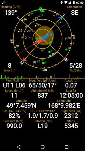
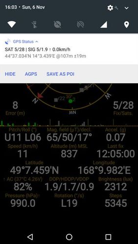
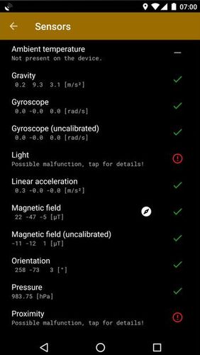
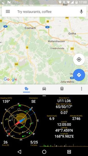
GPS status & toolbox - is a very useful program for working with GPS. This utility is aimed at viewing GPS condition and settings. It can display all data of a sensor and GPS: positions and satellite signal power, accuracy, speed, acceleration, height, step and even battery status.
Game features:
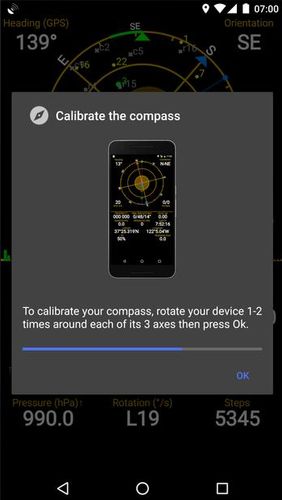
Magnet compass with accurate north
All data of a sensor and GPS
Fast search
Simple and comprehensive interface
Loading video...
Like it? Share with your friends!
Supported operating systems:
Google Android 4.1, Google Android 4.2, Google Android 4.3, Google Android 4.4, Google Android 5.x, Google Android 6.x, Google Android 7.x, Google Android 8.x
Similar Software:
AlpineQuest Lite AlpineQuest Lite - AlpineQuest turns your Android device into an off-road GPS using offline topo maps. It is a complete solution for all outdoor activities and sports, including hiking, running, trailing, hunting, sailing, geocaching and much more
GPS Status & Toolbox GPS Status & Toolbox - Be a GEEK: Get the most out of your phone. Raw GPS data at your fingertips.
Display your GPS and sensor data: position and signal strength of satellites, accuracy, speed, acceleration, bearing.
Tools included: compass with magnetic and true north, leveling tool, mark or share your location and navigate back later
Open GPS Tracker Open Source recording, storing and accessing of your routes: Open GPS TrackerAn application that can track your travels of your Android by storing your GPS locations. Draws the route real-time on either Google or OSM maps
GPS: Speed Pro GPS: Speed Pro - is a satellite navigation system tracking the speed of your vehicle on certain areas of your route. You can set a parameter which will display avarage speed of the trip. The utility controls maximum allowed speed mode and will notify in case of its breach
NAVIGON select NAVIGON MobileNavigator - GPS Navigation NAVIGON MobileNavigator GPS Navigation Very important: ONLY customers who already have one of the previous full versions bought can use this software as an update
Android FindMyCar Android FindMyCar - Innovative software for Android devices that uses the GPS signal to show signs that allow to reach a geographic location.
Suitable for various uses (eg. find car parked in a parking area or in an unknown city, finding a person (who has sent their coordinates) in a lovely beach, in a fair, in another boat, find an area of sea fishing, etc..)
Maverick Off-road GPS navigator with offline maps support, compass and track recording. Use offline maps and GPS even without an internet connection. This app is great for hiking, boating, geocaching and other outdoor activities
AugSatNav Walk AugSatNav is an augmented reality navigation system which overlays walking directions upon a live video feed of the path or road ahead.
With AugSatNav there is no need to follow instructions or interpret maps - you can simply find your way by walking along the route highlighted by a bright white line
ParkLeitSystem ParkLeitSystem is a car-park-routing system. It shows you, according to your GPS position, the nearest city with a car-park-routing system and gives you a list with all available car-parkings and shows how many free places there are. With a click on the parking it switches to google maps and shows you the position of the parking
Comments on GPS status & toolbox:
rob:
Nice
Date: 7 Nov 21
If you noted an error or download link is broken, please, report it via this page or use comments.
GPS status & toolbox is compatible with your device Samsung SM-P555 Galaxy Tab A 9.7 LTE with S Pen / Galaxy Tab A Plus LTE