Ovi Maps 3 takes you where you want to be and shows you what you want to see, with navigable maps for over 70 countries worldwide. All this with only one click. And it's all free.
· Open Maps, Drive, Check in and Guides with a just tap on your home screen.
· Search now includes a tab for favourites. Predictive search also works offline.
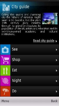
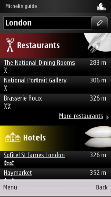
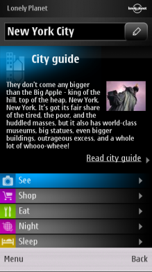
· Place pages have a new design including a new image gallery, user reviews, descriptions by business owners, leading guides and local content providers, e.g. TripAdvisor, HRS, Expedia additionally to Lonely Planet, Michelin guides, TimeOut, Qype and WCities.
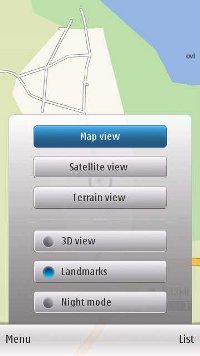
· Easily change the map views in Drive navigation by tapping the views icon. You can pan the map to see the next move and explore the map within the route overview.
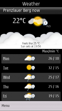
· Tap on Guides and immediately see the weather forecast for your location or another city.
What's New in 3.06:
· Download street maps directly to your device! A new feature called “Update” on the main menu which allows you download Street Maps directly (via WiFi) to your phone without a PC!
· My Position and Search are now integrated (now called Map). When accessed, it will show your last map view
· Back button in Favourites
· Long tap functionality to delete & rename collections & routes
· Pop up for first time use – to inform user to download new map data (when upgrading 3.04 > 3.06 for the first time)
· Improved behaviours of transit lines settings in map toolbox (no more grey out)
· Compass calibration hint
· Refreshed place details information view
What's New in 3.04 / 3.06 beta:
· Visually refreshed main menu and icons,
· New maps with public transport lines (as a new map layer) for subways, trams and trains in 80+ cities around the world. Just click the map toolbox icon and select Transit lines,
· Improved search experience - find places and addresses around you - or anywhere in the world - fast and easily. Browse places or enter a keyword in the search box. Now with suggestions and "did you mean?" functionality,
· New place pages with description, reviews, pictures and places nearby. Interact with places in a whole new way - you can check in, contact, navigate, save, rate, share, report or see place on the map,
· Share a place - send a place to your friends via SMS or Email. The SMS contains the address and a link to the place page with description, ratings, contact, URL and a mini map. The link opens up on the mobile browser (also on non-Nokia devices),
· Check in - keep your friends up-to-date with where you are and what you're up to. Check in to places and share it with your friends on Facebook and many more social networks. See places you’ve been to in your check in history,
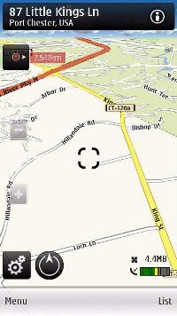
· New Drive assistance mode with live traffic flow - after clicking Drive, you're instantly in drive assistance mode with live traffic flow and more. Once you start moving, get safety camera alerts and speed limit warnings
· More folder with many rich content services relevant to your location. Personalise your Ovi Maps by selecting the services you'd like to keep on your main menu for instant access.
Like it? Share with your friends!
If you got an error while installing Themes, Software or Games, please, read FAQ.
Psiloc World Traveler Psiloc World Traveler is a breakthrough open platform application developed by Psiloc that is aimed to make a business traveler’s life easier. The currently released version offers four basic FREE for end user services:
* Weather - a five day weather forecast and current conditions for around 2200 most popular travel locations worldwide
Map of Swaziland Map of Swaziland - A map of Swaziland. Good for intercity travels with SmartMap.
Layers include:
Towns
Settlements
Airports
Roads
Railroads
Rivers
Inland water
Administrative borders
International borders
Trees
Map scale is 1:1 million.
Good for use with any version of SmartMap. SmartMap can be purchased here
Travel Delhi, India - Illustrated Guide and Maps Travel Delhi, India - Illustrated Guide and Maps-
An illustrated guide, phrasebook, and maps. Indulge Yourself with a personal tour guide on Your PDA. FREE general information, phrasebook, and a map in the trial version.
Features
Fully illustrated.
Historical overviews.
Interesting facts.
Street and attractions maps
Tube Seoul (Series 60) Tube Seoul (Series 60) - Our highly acclaimed Tube application that guides you around the complex subway system of Seoul is now available for your Series 60 Symbian powered phone. An essential addition to your phone for locals and tourists alike.
· A detailed clear colour map of the Seoul subway system fully scrollable.
· Quick find station utility
Map of Sudan Map of Sudan - A map of Sudan, divided into 9 smaller territories for the ease of use.
ASH SHARQIYAH
ASH SHAMALIYAH
DARFUR
AL KHARTUM
KURDUFAN
AL WUSTA
A'ALI AN NIL
BAHR AL GHAZAL
AL ISTIWA'IYAH
Good for intercity travels with SmartMap
Travel Rocky Mountain National Park Travel Rocky Mountain National Park is a comprehensive travel guide illustrated with maps and photographs. Indulge Yourself with a personal tour guide on Your PDA. FREE General Information chapter and a map in the trial version.
Features
Fully illustrated.
Geology, Flora, Fauna and more.
Interesting facts.
Trail Maps and more
Map of Uruguay Map of Uruguay - A map of Uruguay. Good for intercity travels with SmartMap.
Layers include:
Towns
Settlements
Airports
Roads
Railroads
Rivers
Inland water
Administrative borders
International borders
Trees
Map scale is 1:1 million.
Good for use with any version of SmartMap. SmartMap can be purchased here
ViewRanger GPS Premium ViewRanger GPS Premium- turns your phone into a fully-featured off-road satnav with detailed topographic mapping. This pack includes tokens to download topographic maps directly to your phone.
ViewRanger is ideal for tourists, walkers, cyclists, mountain bikers, horse riders, geocachers, river boaters - in fact anyone who enjoys the outdoors
Map of Utah (US State) Map of Utah (US State) - A map of the Utah by VITO Technology. Good for intercity travels with SmartMap.
SmartMap is a mobile device application which uses vector and raster maps. It is compatible with any NMEA protocol GPS receiver (Compact Flash socket, serial port, BlueTooth or sleeve)
Travel Zurich, Switzerland - illustrated city guide, phrasebook, and maps Travel Zurich, Switzerland - illustrated city guide, phrasebook, and maps- An illustrated city guide, phrasebook, and maps. Indulge Yourself with a personal tour guide on Your PDA. FREE general information chapter and a map in the trial version.
Features
Fully illustrated.
Historical overviews.
Interesting facts
Other Software by developer «Nokia»:
Nokia Mobile Dictionary Hebrew Nokia Mobile Dictionary Hebrew- is a dictionary application for translating words from one language to another. In addition to pre-installed language(s) you may download additional dictionary languages.
The dictionary application allows you to have English and two user-defined languages on your device at the same time
Nokia Step Counter Nokia Step - Ever wanted to know how much you walk or run as you go about your daily life? Nokia Step Counter not only counts your steps, it also determines the distance you have covered and your energy expenditure. You can even compare your activity levels on different days by looking up the summaries stored in a handy diary
Qt Phone Demos Qt Phone Demos-that illustrate the new features brought by Qt 4.6.0: the new version of the cross-platform application and UI framework for desktop, embedded and mobile application and service development.
These demos run on S60 v3.1, 3.2 and 5.0 phones. The .sis file will install Open C, Qt and fluidlauncher all in one go
Nokia Magnifier Nokia Magnifier application utilizes the existing camera functionality on your Nokia S60 phone. It can be used to improve readability in every-day life situations such as reading "fine print". Anyone who has difficulty seeing "fine print" or small objects can benefit from using this application readily available on their S60 phone
MeeScan MeeScan is the N9 application for scanning 1-d and 2-d barcodes, such as UPC, QR, and Data Matrix codes. The application also identifies many types of actionable text encoded in 2-d barcodes as contact, web URL, iCal event or text, and allows relevant action. MeeScan uses ldmtx and zbar libraries
Nokia Photos With Nokia Photos, you can transfer your photos and videos to your PC, organize and geotag them, and share them on Ovi. Also, you can load your phone with photos and videos from your PC, converted into compatible format
HERE Transit for Asha Travel app that allows you to easily find your way to the selected destination in the biggest cities all over the world using public transportation. HERE Transit turns your Nokia Asha phone into a handy public transportation assistant that can help you find your way in more than 800 cities from 53 countries around the world
Nokia Bubbles Bubbles is a fun and efficient way to take a shortcut to timely or useful things on your mobile phone. Bubbles appears when you press the "Apps" key while your device is in sleep mode (instead of the black screen with clock and unlock button). Simply grab a bubble and drag it to one of the available drop points to initiate the corresponding action
Nokia Multimedia Factory Nokia Multimedia Factory - Create multimedia messages on your PC and send them through your connected phone.
Note: Before downloading, ensure that you have the latest version of PC Suite installed on your PC
Nokia Maps Suite Nokia Maps Suite - Nokia Maps Suite brings you the future of location-based services. Places helps you discover where to go and Public Transport shows the best way to get there with buses, trams and trains with worldwide coverage


")


")


