MetrO (S80) - Metro finds your way in public transport systems in more than 350 cities around the world (Paris, New York, London, Tokyo, any city with a subway & many more!).
· Fully assisted station search (various lists selection or text entry options)
· Station list for each line
· Recently used stations history
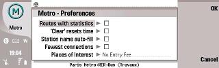
· Operating hours management (in selected cities)
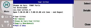
· Places of interest: tourism, night life, ... and detailed information (in selected cities)
· Line deactivation option (in case of strikes or works)
· Line colors in the stop list and in the calculation results
· Contacts list interface (enter your contact's subway stations only once)
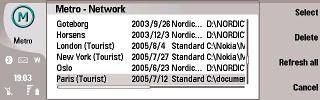
· Install only the cities you need (and save memory)
· Extension card compatibility
· City databases exchange through IR interface
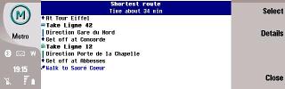
· Two different routes suggested (fastest and least connections)
· More than 250 cities included, most of them with complete information (575 stations in London, 785 in New-York, 1600 in Tokyo, 839 in Paris), including suburban systems, buses, trams, ferries...
· Frequent updates (every month) for up-to-date information
· Available in 34 languages
What's New in This Release:
· New cities: Aix en Provence (France), Kufstein (Austria)
· Major city changes: Beijing, Charleroi, Forbach
· Other changes: Banska Bystrica, Berlin, Bratislava, Brest, Budapest, Cairo, Cali, Chongqing, Delhi, Dresden, Grenoble, Hambourg, Kiev, Kosice, Lille, London, Medellin, Montlucon, Murcia, Nuremberg, Paris, Povazska Bystrica, Prague, Presov, Saint Petersbourg, Seoul, Singapore, Sydney, Taipei, Tehran, Toulouse, Trnava, Wroclaw
Like it? Share with your friends!
If you got an error while installing Themes, Software or Games, please, read FAQ.
Supported operating systems:
S80 7.0
Similar Software:
A-Z London Street Map 100sqkms S60 010060 A-Z London Street Map 100sqkms S60 010060 covers Central London in great detail. The clear and colourful maps are based on the market leading London A-Z maps. The familiar looks make this by far the easiest smartphone map to use in real life.
The area covered is 100 square kilometers, ie. 10 x 10 km. This is equivalent to 6.2 x 6.2 miles = 38.6 square miles
MicroSky v3 c BT Api MicroSky is a planetarium for mobile/cell devices with Java-support and a connection to the Internet (preferably GPRS or UMTS). It is a very small J2ME-Midlet client/server application which retrieves its starcharts from the skyserver
Travel Zurich, Switzerland - illustrated city guide, phrasebook, and maps Travel Zurich, Switzerland - illustrated city guide, phrasebook, and maps- An illustrated city guide, phrasebook, and maps. Indulge Yourself with a personal tour guide on Your PDA. FREE general information chapter and a map in the trial version.
Features
Fully illustrated.
Historical overviews.
Interesting facts
Travel Zion National Park - illustrated travel guide and maps Travel Zion National Park - illustrated travel guide and maps is a comprehensive travel guide illustrated with maps and photographs. Indulge Yourself with a personal tour guide on Your PDA. FREE General Information chapter and a map in the trial version.
Features
Fully illustrated.
Geology, Flora, Fauna and more.
Interesting facts.
Maps
Travel Mammoth Cave National Park - illustrated travel guide and maps Travel Mammoth Cave National Park - illustrated travel guide and maps is a comprehensive travel guide illustrated with maps and photographs. Indulge Yourself with a personal tour guide on Your PDA. FREE General Information chapter and a map in the trial version.
Features
Fully illustrated.
Geology, Flora, Fauna and more.
Interesting facts
MetrO (S80) MetrO (S80) - Metro finds your way in public transport systems in more than 350 cities around the world (Paris, New York, London, Tokyo, any city with a subway & many more!)
Travel Miami Beach and Miami (Symbian S60) Travel Miami Beach and Miami (Symbian S60) is a comprehensive travel guide to Miami. Indulge Yourself with a personal tour guide on Your PDA. FREE General Information chapter in the trial version.
Features
Fully illustrated.
Historical overviews.
Interesting facts.
City Maps.
Museums address, telephone, hours and admission information
Ho Chi Minh Map for SmartComGPS Ho Chi Minh Map for SmartComGPS - This map is an only calibrated offline map for Ho Chi Minh city, you need to have software SmartComGPS from www.wild-mobile.com, copy the map file to folder Memory CardDataSmartComGPSMAPS then you are ready to explore every detail corner of Ho Chi Minh city. A large data map required 24 MB free on storage card
Travel Montreal Guide, Phrasebook, and Maps Travel Montreal Guide, Phrasebook, and Maps-
An illustrated city guide, phrasebook, and maps. Indulge Yourself with a personal tour guide on Your PDA. FREE General Information chapter and a map in the trial version.
Features
Fully illustrated.
Historical overviews.
Interesting facts.
Street and attractions map, metro map and more
Travel Tokyo, Japan - illustrated guide, phrasebook, and maps Travel Tokyo, Japan - illustrated guide, phrasebook, and maps - An illustrated travel guide, phrasebook, and maps. Indulge Yourself with a personal tour guide on Your PDA. FREE General Information, basic phrasebook, and a map in the trial version.
Features
Fully illustrated.
Historical overviews.
Interesting facts. City Attractions
Other Software by developer «P.Bernard, F. Van Caenegem»:
MetrO (S80) MetrO (S80) - Metro finds your way in public transport systems in more than 350 cities around the world (Paris, New York, London, Tokyo, any city with a subway & many more!)
MetrO (UIQ) MetrO (UIQ) - Metro finds your way in public transport systems in more than 350 cities around the world (Paris, New York, London, Tokyo, any city with a subway & many more!)
MetrO (S60 3rd Edition) MetrO (S60 3rd Edition) - Metro finds your way in public transport systems in more than 350 cities around the world (Paris, New York, London, Tokyo, any city with a subway & many more!)
MetrO S60 Metro helps you find your way in the public transport systems (subway, bus, trams, ...) in more than 400 cities around the world. FREE, FAST & ACCURATE. Simply enter you start and end stops, hit the "Go" button and the program finds the fastest route.
Many more features to discover!
After downloading, please read the included "readme
MetrO (UIQ) MetrO (UIQ) - Metro finds your way in public transport systems in more than 350 cities around the world (Paris, New York, London, Tokyo, any city with a subway & many more!)
MetrO (UIQ) MetrO (UIQ) - Metro finds your way in public transport systems in more than 350 cities around the world (Paris, New York, London, Tokyo, any city with a subway & many more!)
MetrO (UIQ) MetrO (UIQ) - Metro finds your way in public transport systems in more than 350 cities around the world (Paris, New York, London, Tokyo, any city with a subway & many more!)
MetrO Pocket PC Metro finds your way in public transport systems in more than 350 cities around the world (Paris, New York, London, Tokyo, any city with a subway & many more!).
FREE, FAST & ACCURATE
MetrO (iPhone) MetrO (iPhone) - MetrO helps you find your way in the public transportation in more than 400 cities around the world.
One application for all your trips: download the cities you need and search your route by subway, bus, railway, tram ... (depending on cities). NO network connection is required after you have installed the cities
MetrO Smartphone Metro helps you find your way in the public transport systems


")

")


")
")


")
")
")

")
")
")

")
