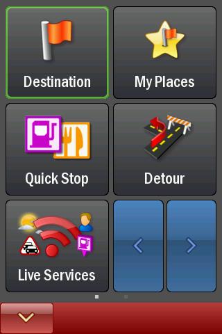
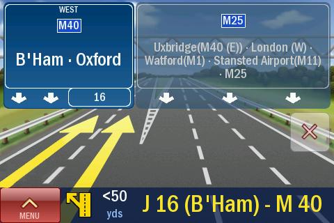
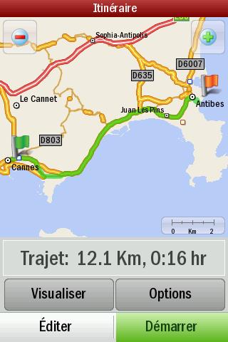
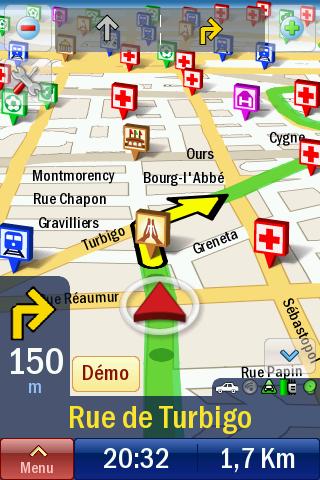
CoPilot Live Europe (Android) - CoPilot Live is full-featured voice-guided GPS navigation with Western and Eastern Europe street maps stored on your phone. Includes 3D guidance, lane assist, speed limit warnings, safety camera alerts, planning mode.
Download maps via WiFi after purchase. Unlimited use after 10 days once Google order verified.
What's New in This Release:
· Now fully compatible with Android OS 4.0 (aka Ice Cream Sandwich)
What's New in 8.2.0.904:
· This update brings you a FREE map update. The latest digital street maps provided with our compliments!
What's New in 8.2.0.814:
· Fixes a full Europe map download issue.
What's New in 8.2.0.751:
· This update introduces ActiveTraffic - a major upgrade to our optional Live traffic service. ActiveTraffic uses real-time traffic flow information to calculate the fastest route to your destination. If a delay is detected, CoPilot Live will search for an alternative, faster route.
· Also in this update, Live Local Search is now available as standard in all countries.
What's New in 8.2.0.590:
This build fixes:
· Android OS 1.5 crash on launch
· Android WiFi devices receiving "Invalid IMEI" message
Like it? Share with your friends!
Supported operating systems:
Google Android 1.5, Google Android 1.6, Google Android 10.x, Google Android 2.0, Google Android 2.1, Google Android 2.2, Google Android 2.3, Google Android 3.0, Google Android 3.1, Google Android 3.2, Google Android 4.0, Google Android 4.1, Google Android 4.2, Google Android 4.3, Google Android 4.4, Google Android 5.x, Google Android 6.x, Google Android 7.x, Google Android 8.x, Google Android 9.x
Similar Software:
Osmand: Maps and Navigation Osmand: Maps and Navigation - is a navigation utility. Support of electronic maps gives you a chance to get new updates all the time. The map has marks which will help tourists. Embedded satellite navigation allows you to make the shortest route fast
OSMTracker for Android OSMTracker stands for OpenStreetMap Tracker. It allows you to track your journey and mark significant way points. Way points can be marked with a tag using a button, with a quick voice record, a text note or by taking a picture. The various button pages and layouts can be customized to suit your OpenStreetMap activities
ShareYourDrive ShareYourDrive Transportation and cars especially are contaminating. Imagine with a few clicks, you can know who can give you a ride. The time real geolocalisation to save environment. Don't be afraid about security. Historic helps to know who was with you, when and where. Moreover you can give a rate to the persons you meet
TripComputer TripComputer is a personal off-road GPS navigation utility software for Android phones, that has been created for active people, who love travel by hike or bike.
The application does not use Internet connection or Google Maps for navigation or track recording, but you can share your data to others, or store your data on server
JTrip JTrip - Create your own trip in Thailand. JTrip recommends attractions and directions that you need. Let's get to know Thailand together.
· select places.
· select hotel.
· show map location.
· route path form src to dest.
· taxi, time remaining.
· suggest bus number
amAze (LG) AmAze is a first of its kind free navigation and local search service. It is free to download and use and it contains wide coverage of maps including aerial photo in Europe, North America, Australia and parts of Asia and Africa
MapMakr MapMakr If you’re an aid worker responding to a humanitarian crisis, up to date, accurate, and easy to read maps are vital. Knowing whether a bridge has collapsed, a road is passable and where you can land planes bringing in aid is really important
amAze GPS light edition amAze GPS light edition provides access to worldwide street maps, full topographic map coverage of the USA and satellite imagery for 200 major cities around the world. It allows you to search in a worldwide rich POI database and you can upgrade to the full version that includes turn-by-turn voice guided navigation from within the application
Outdoor Offline Maps for Android Outdoor Offline Maps for Android - The Outdoor Navigation software is your best friend through your adventures in the wild.
Go into the outdoors with confidence and enjoy your activities without worrying about the tools to help you navigate. Your Outdoor Navigation app is made by the people who have been developing this software since 2003 across multiple platforms
amAze (Samsung) AmAze is a first of its kind free navigation and local search service. It is free to download and use and it contains wide coverage of maps including aerial photo in Europe, North America, Australia and parts of Asia and Africa
Other Software by developer «ALK Technologies»:
CoPilot Live HD Europe CoPilot Live HD Europe - With its sensational hi-resolution graphics, CoPilot Live HD gives you the ultimate in-car guidance experience.
Price includes maps of ONE European region. Choose your region the first time you run the application. You can also buy complete maps of Europe through in-app purchase
CoPilot Live BeNeLux CoPilot Live BeNeLux - Welcome to CoPilot Live, the award-winning sat navigation app that runs on your iPhone to guide you door to door with complete street maps of Belgium, Netherlands and Luxembourg.
CoPilot Live is the personal travelling assistant who's always at your side, ready to guide you to the door with turn-by-turn voice directions
CoPilot Live France CoPilot Live France - Welcome to CoPilot Live, the award winning turn-by-turn iPhone sat navigation app with complete street maps of France and door to door voice directions.
CoPilot Live is packed full of advanced navigation features to guide you easily and accurately, including clear 3D map displays, lane indicator arrows and speed limit alerts
CoPilot Live Iberia CoPilot Live Iberia - Welcome to CoPilot Live, the award winning turn-by-turn iPhone sat navigation app with complete street maps of Spain and Portugal and door to door voice directions.
CoPilot Live is packed full of advanced navigation features to guide you easily and accurately, including clear 3D map displays, lane indicator arrows and speed limit alerts
CoPilot Live Premium DACH CoPilot Live Premium DACH is the essential voice-guided sat navigation app to get you where you need to go, by the way that suits you best.
Detailed street maps of DACH (Germany, Austria and Switzerland) are stored on-board your iPhone so you don’t need to rely on your mobile connection for navigation or worry about losing directions in coverage dead spots
CoPilot Premium Italy for iOS CoPilot Premium Italy for iOS - CoPilot is a powerful GPS navigation solution for iPhone, iPad and iPod touch. The app comes with downloadable maps of Italy, which can be used offline, allowing you to find your way even when you don't have an internet connection
CoPilot Live South Africa CoPilot Live South Africa - Welcome to CoPilot Live, the award-winning GPS navigation app that runs on your iPhone to guide you door to door throughout South Africa, Lesotho, Swaziland, Namibia and Botswana.
Detailed street maps are stored on your phone, not downloaded each trip, so there's no need for map downloads over the mobile internet
CoPilot Live Premium HD North America CoPilot Live Premium HD North America - Now there's a better way to navigate. CoPilot Live Premium HD is a new voice-guided GPS navigation app for the iPad 3G
CoPilot Live Premium UK & Ireland CoPilot Live Premium UK & Ireland - CoPilot Live Premium is the essential voice-guided sat navigation app to get you where you need to go, by the way that suits you best.
Detailed street maps of UK and Ireland are stored on-board your iPhone so you don’t need to rely on your mobile connection for navigation or worry about losing directions in coverage dead spots
CoPilot Truck HD North America CoPilot Truck HD North America - Introducing CoPilot Truck HD—the first iPad app that provides full-featured voice-guided GPS navigation designed specifically for professional drivers of trucks


")


")


")


