Outdoor Share for Android - The Outdoor Navigation software is your best friend through your adventures in the wild.
Go into the outdoors with confidence and enjoy your activities without worrying about the tools to help you navigate. Your Outdoor Navigation app is made by the people who have been developing this software since 2003 across multiple platforms. Be sure that you will stay ahead of the rest with continuous updates and relevant tools.
It is an excellent tool for biking, jogging, skiing, hiking, geocaching, boating, flying and many other sporting activities.
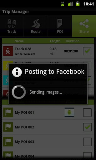
Your Outdoor Share will give you the ability to take those valuable tracks and POIs that you have created with your Outdoor Navigation base application and share them with your Facebook pals by uploading them to your Facebook account.
· Allows to share tracks and POIs with Facebook (besides the sharing via mail that is available also in the base version)
Installation instructions:
Outdoor Share is an add-on for the free Outdoor Navigation application. You need to have your Outdoor Navigation installed to be able to use Outdoor Share.
Download and install Outdoor Share on your Android device. Start the Outdoor Share plugin to complete the license checking: when activation will be completed then the icon will be removed (you need to restart your device to hide the icon) and the plugin will be used inside Outdoor Navigation application.
What's New in This Release:
· Bug fixing
Like it? Share with your friends!
Supported operating systems:
Google Android 10.x, Google Android 2.1, Google Android 2.2, Google Android 2.3, Google Android 3.0, Google Android 3.1, Google Android 3.2, Google Android 4.0, Google Android 4.1, Google Android 4.2, Google Android 4.3, Google Android 4.4, Google Android 5.x, Google Android 6.x, Google Android 7.x, Google Android 8.x, Google Android 9.x
Similar Software:
GPS Location Lite GPS Location Lite - Use your Android phone as a professional GPS logging device.
Record different tracks and export gpx-files to sdcard.
View Distance, Time, Speed, Altitude, Latitude and Longitude.
In the GPS Location Lite settings you could choose gps or network provider. GPS interval (5-60 seconds) and some other preferences are adjustable
InstaMapper (Android) InstaMapper is a free service that allows you to track a person or vehicle online in real time using a GPS-enabled mobile phone.
To use InstaMapper, you create a free account. Registration takes only a minute or two. All it is asked for is a username, password, and a valid email address.
Next, you install a small application on your GPS-enabled phone
ViewRanger GPS ViewRanger is a unique mapping, navigation, tracking, and information tool for mobile phones that provides fully featured outdoor gps and trail navigation through a natural and intuitive display. ViewRanger transforms a Nokia or other Symbian S60 smartphone into a fully featured trail navigation system
Track Location Track Location is an Android app which uses GPS or your network to display your location anywhere in the world. You can see the latitude and longitude of your current position and save the coordinates
Radardroid Lite GPS speed camera warning application for Android devices. Radardroid will give a visual and audible warning when you approach any fixed or mobile speed camera in the application database. This application will give you advanced warning of possible danger ahead and will reduce possible speeding tickets thanks to the ever increasing available features
Waze Waze is a free, 100% user-generated, social navigation application that allows drivers to build and use live maps & real-time traffic updates to improve their daily commute
My Fleet Geofence My Fleet Geofence - Why do you need My Fleet Geofence application?
1. With My Fleet Geofence, you can create a specific "safe zone" or "unauthorized zone" on a map and get an E-mail Alert if the phone leaves the area.
2. Receive an instant alert in case of breach of specific zone.
How to start?
1. Install the application on your Android phone.
2
GPS Widget GPS Widget - This widget simply shows your current location in numbers. Latitude and Longitude are received from the GPS location provider or from the network location provider if GPS is not available.
The altitude is queried from open MapQuest API which yields in a more accurate result than receiving the altitude by GPS
Red Panic Button (Android) Red Panic Button - When you are in trouble press the Red Panic Button! You just have to set a panic number and the mobile phone will send a sms which contains a link to Google Maps with your fine GPS based or coarse GSM based coordinates.
What's New in This Release:
· New Feedback button!
· QVGA and WVGA screen layout improvements!
What's New in 2
TwoNav for Android TwoNav for Android - A dual navigation system (On-Road/Off-Road) to perform most of your outdoor activities (hiking, biking, skiing, geocaching, ...). TwoNav can also guide you when driving. A single solution for all your orientation needs
Other Software by developer «GPS Tuner»:
GPS Tuner Essentials Full Version with France, Monaco, Belgium, Switzerland Basic Map Content GPS Tuner Essentials Full Version with France, Monaco, Belgium, Switzerland Basic Map Content is designed specifically for off-road use: its large buttons, selectable tool window size, multiple Compass views and the built-in Tele Atlas map makes it extremely user-friendly and reliable
Outdoor Speedometer for Android Outdoor Speedometer for Android - The Outdoor Navigation software is your best friend through your adventures in the wild.
Go into the outdoors with confidence and enjoy your activities without worrying about the tools to help you navigate. Your Outdoor Navigation app is made by the people who have been developing this software since 2003 across multiple platforms
GPS Tuner Essentials Full Version with British Isles Basic Map Content GPS Tuner Essentials Full Version with British Isles Basic Map Content is designed specifically for off-road use: its large buttons, selectable tool window size, multiple Compass views and the built-in Tele Atlas map makes it extremely user-friendly and reliable
GPS Tuner Essentials Full Version with Germany, Austria, Switzerland Basic Map Content GPS Tuner Essentials Full Version with Germany, Austria, Switzerland Basic Map Content is designed specifically for off-road use: its large buttons, selectable tool window size, multiple Compass views and the built-in Tele Atlas map makes it extremely user-friendly and reliable
GPS Tuner Essentials Full Version with Italy and Malta Basic Map Content GPS Tuner Essentials Full Version with Italy and Malta Basic Map Content is designed specifically for off-road use: its large buttons, selectable tool window size, multiple Compass views and the built-in Tele Atlas map makes it extremely user-friendly and reliable
GPS Tuner Essentials GPS Tuner Essentials is designed specifically for off-road use: its large buttons, selectable tool window size, multiple Compass views make it extremely user-friendly and reliable
GPS Tuner Essentials Full Version with United States Basic Map Content GPS Tuner Essentials Full Version with United States Basic Map Content is designed specifically for off-road use: its large buttons, selectable tool window size, multiple Compass views and the built-in Tele Atlas map makes it extremely user-friendly and reliable
Outdoor SOS for Android Outdoor SOS for Android - The Outdoor Navigation software is your best friend through your adventures in the wild.
Go into the outdoors with confidence and enjoy your activities without worrying about the tools to help you navigate. Your Outdoor Navigation app is made by the people who have been developing this software since 2003 across multiple platforms
Outdoor Chart for Android Outdoor Chart for Android - The Outdoor Navigation software is your best friend through your adventures in the wild.
Go into the outdoors with confidence and enjoy your activities without worrying about the tools to help you navigate. Your Outdoor Navigation app is made by the people who have been developing this software since 2003 across multiple platforms
GPS Tuner Essentials Full Version with Baltic Basic Map Content GPS Tuner Essentials Full Version with Baltic Basic Map Content - is designed specifically for off-road use: its large buttons, selectable tool window size, multiple Compass views and the built-in Tele Atlas map makes it extremely user-friendly and reliable


")


")


