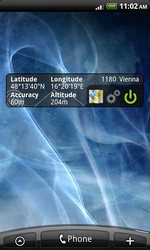
GPS Widget - This widget simply shows your current location in numbers. Latitude and Longitude are received from the GPS location provider or from the network location provider if GPS is not available.
The altitude is queried from open MapQuest API which yields in a more accurate result than receiving the altitude by GPS. So this widget is also interesting for hiking (altimeter).
Features:
· Display your current location in numbers
· Additional information (Street, City)
· Shows your altitude with high accuracy
Locked features (can be unlocked with some Good Karma):
· Share your location with friends via SMS, Email, etc.
· Different location formats are supported (Decimal Degrees, Universal Transverse Mercator (UTM), ...)
Note 1: To save battery power you should switch off the widget when you do not need it. You can force the widget to switch off automatically after some time in the settings.
Note 2: This is no GPS toggle widget. You can not turn on and off GPS. You simply get clear information about your current location.
To add widget press: Home->Menu->Add->Widgets->GPS Widget
If you like the widget, you can donate to the developer (it's free for you) and earn some Good Karma Points in the settings view!
The widget needs the following permissions because:
· Your location: it's obvious
· Network communication: query altitude, donation via Tapjoy
· Storage*: donation via Tapjoy
· Phone calls*: donation via Tapjoy
(*) You don't want to accept these permissions? Get "GPS Widget Pro" without the option to donate -> no "Storage" and "Phone calls" permission is required.
What's New in This Release:
· GPS satellite fix can be displayed
· higher accuracy (now 6 decimal digits)
· ornaments in background can now be removed
· Bug fix
What's New in 1.1.0:
· alternative location formats (UTM, etc.)
· display altitude in meters or feet
· Share location with others via SMS, Email,...
Like it? Share with your friends!
Supported operating systems:
Google Android 10.x, Google Android 2.1, Google Android 2.2, Google Android 2.3, Google Android 3.0, Google Android 3.1, Google Android 3.2, Google Android 4.0, Google Android 4.1, Google Android 4.2, Google Android 4.3, Google Android 4.4, Google Android 5.x, Google Android 6.x, Google Android 7.x, Google Android 8.x, Google Android 9.x
Similar Software:
GPS Coordinates Converter GPS Coordinates Converter - With this app you can convert GPS coordinates from "degrees, minutes, decimal seconds" to "decimal degrees".
What's New in This Release:
· Locate your phone and show the coordinates
What's New in 2
AlpineQuest AlpineQuest - AlpineQuest turns your Android device into an off-road GPS using offline topo maps. It is a complete solution for all outdoor activities and sports, including hiking, running, trailing, hunting, sailing, geocaching and much more
PhonAlarm PhonAlarm - Start PhonAlarm to make surroundings, friends/family aware of an emergency, and with the GPS location started in your phone, they can immediately locate you. How can PhonAlarm help you and how does it work? If a situation is emerging where you need to be assisted by others, e.g
MileageLedger (Android) MileageLedger is a GPS powered mileage logging application designed for Android enabled phones. The paid version of MileageLedger generates log files that meet requirements of IRS Publication 463, Section 5 which states:
"You should keep adequate records to prove your expenses or have sufficient evidence that will support your own statement
gOmniTracker (Android) GOmniTracker wonder where was your teenager spending time last night? or when did they leave school, home, or tennis-practice? Or maybe its granny you are concerned about whether she got back home from the park yet? gOmniTracker can answer these questions, and more, right from your Mobile Device
Weather Forecast USA Weather Forecast USA- Displays 7-day forecast for any location in US (Alaska, Puerto Rico, Hawaii and Guam included). Location is determined via GPS on your device, so don''t forget to turn it on. Forecast is obtained from NOAA web services where it is refreshed hourly
TomTom Iberia for Android TomTom Iberia for Android - TomTom Iberia is a turn-by-turn GPS navigator for Android devices. The app includes accurate offline maps, so you can find your way anywhere, even without an internet connection
Digital Dashboard GPS Digital Dashboard GPS - Features included
- Save your track info,Record gpx file(it will be saved in "sdcard/DigitalDashboardGPS/gpx/")..
- Switch between car speedometer and bike cyclometer.
- Switch between mph or km/h mode.
- Display satellites status.
- Speed chart.
- Map integration,get your location.
……
Facebook:https://www.facebook
Location Barcoder Location Barcoder is a tool for creating geocoded barcodes based on your location. Barcodes are stored on the SDCard in a folder named LocationBarcodes
Other Software by developer «Wolfgang Knecht»:
not found
Comments on GPS Widget:
Comments not found
If you noted an error or download link is broken, please, report it via this page or use comments.
GPS Widget is compatible with your device Sharp IS05


")


