Platforms: iPhone, iPad, iPod Touch, Apple iPhone OS
Categories: Science & Education
Upload date: 3 Jan 12
Developer: VITO Technology
License: Commercial
Price: 2.99 $
Downloads: 199
Solar Walk - Let's find out more about our neighboring planets in the Universe, play around with them determining the speed of circulation, time, choosing a particular planet to become the center of the Universe, seeing the moons of Saturn, Jupiter, Mars and Urano. The 3D model in the Solar Walk app is the exact reproduction of the real solar system.
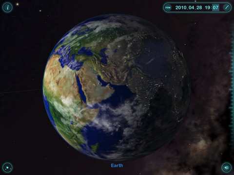
Solar Walk stands out among other astronomy applications having a very beautiful and smooth graphics and animations. The Earth as well as other planets look so realistic that you can even see the clouds together with the relief of mountains, lakes, oceans.
Benefit greatly from using Solar Walk for interactive learning and getting closer to the universe!
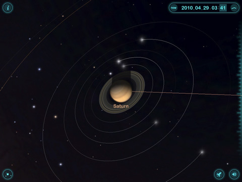
· 3D SOLAR SYSTEM: play with the 3D model by moving around the Solar System. Zoom in, zoom out, investigate it from different angles. You can observe not only the current position of planets in our solar system but also learn their position at a definite period of time in the past or in the future! For this use Time Machine feature.
· FLY to the PLANET: having chosen a planet from a far, tap an image of a "rocket" to fly straight to the planet. Enjoy a beautiful and realistic image of a planet!
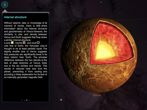
· READ INFO about the planet: by tapping the "i" button you learn general info about the planet, its name, its mass, radius, distance to the sun, internal structure with the picture and science missions.
· TIME MACHINE: click on the clock icon and date and time will be displayed. Slide your finger on the scale and the sky will start moving accordingly. Touch year, month and time and change them depending on what you want to see, the display will adapt accordingly to show you how planets were aligned at that time.
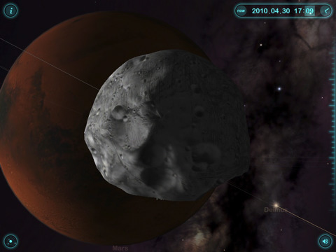
· MOONS of DIFFERENT PLANETS: select a planet like Earth, Saturn, Jupiter, Mars or Urano and observe how many moons they have and their track around the planet. Select one of the moons and learn.
What's New in This Release:
· The Aseroid belt
· The Solar prominence
· The bug with 3D TV fixed
What's New in 1.9:
· Voice-over for educational movies
· Localized subtitles for movies in Chinese, French, German, Italian, Japanese, Korean, Russian, Spanish
· Uranus rings
· The clouds texture for Venus
· New texture for Mercury
· Minor interface tweaks
What's New in 1.8:
· The first app in the AppStore with real 3D TV Support (the feature works only on 3D TVs)
· External TV Support: make your classroom activities even more spectacular with presentation of 3D Solar System on a big screen
· 3D Models of Main Satellites with real time trajectories: be a part of our Universe and fly on a Satellite over the Earth
· 3 New Educational Movies: Tidal Phenomena, Major Circles of Latitude, Zodiacal Constellations.
· More Detailed Earth Texture
What's New in 1.7:
· Search for planets, satellites, stars
· New enhanced interface
· Three new educational films: Earth's Cycles, Solar Eclipse, The Moon Phases
· Sharing beautiful views of the Universe via Twitter, Facebook and e-mail
· Bug fixes (Saturn's rings, minor bugs)
Like it? Share with your friends!
If you got an error while installing Themes, Software or Games, please, read FAQ.
Supported operating systems:
Apple iOS 10.x (iPad), Apple iOS 10.x (iPhone), Apple iOS 11.x (iPad), Apple iOS 12.x (iPad), Apple iOS 12.x (iPhone), Apple iOS 4.0.x (iPhone), Apple iOS 4.0.x (iPod Touch), Apple iOS 4.2.x (iPad), Apple iOS 4.2.x (iPhone), Apple iOS 4.2.x (iPod Touch), Apple iOS 4.3.x (iPad), Apple iOS 4.3.x (iPhone), Apple iOS 4.3.x (iPod Touch), Apple iOS 5.0 (iPad), Apple iOS 5.0 (iPhone), Apple iOS 5.0 (iPod Touch), Apple iOS 6.0 (iPad), Apple iOS 6.0 (iPhone), Apple iOS 6.0 (iPod Touch), Apple iOS 7.0 (iPad), Apple iOS 7.0 (iPhone), Apple iOS 7.0 (iPod Touch), Apple iOS 8.x (iPad), Apple iOS 8.x (iPhone), Apple iOS 8.x (iPod Touch), Apple iOS 9.x (iPad), Apple iOS 9.x (iPhone), Apple iOS 9.x (iPod Touch), Apple iPhone OS 3.1.x, Apple iPhone OS 3.1.x (iPod Touch), Apple iPhone OS 3.2.x (iPad)
Map of North Carolina (US State) Map of North Carolina (US State) - A map of the North Carolina by VITO Technology. Good for intercity travels with SmartMap.
SmartMap is a mobile device application which uses vector and raster maps. It is compatible with any NMEA protocol GPS receiver (Compact Flash socket, serial port, BlueTooth or sleeve)
Map of Western Sahara Map of Western Sahara - A map of Western Sahara. Good for intercity travels with SmartMap.
Layers include:
Towns
Settlements
Airports
Roads
Railroads
Rivers
Inland water
Administrative borders
International borders
Trees
Map scale is 1:1 million.
Good for use with any version of SmartMap
Map of Tennessee (US State) Map of Tennessee (US State) - A map of the Tennessee by VITO Technology. Good for intercity travels with SmartMap.
SmartMap is a mobile device application which uses vector and raster maps. It is compatible with any NMEA protocol GPS receiver (Compact Flash socket, serial port, BlueTooth or sleeve)
Map of South Korea Map of South Korea -
A map of South Korea. Good for intercity travels with SmartMap.
Layers include:
Towns
Settlements
Airports
Roads
Railroads
Rivers
Inland water
Administrative borders
International borders
Trees
Map scale is 1:1 million.
Good for use with any version of SmartMap
VITO AudioNotes VITO AudioNotes is a Windows Mobile audio recorder. It is the easiest Pocket PC recorder for recording voice notes, lectures, interviews, negotiations or anything else you like to your Pocket PC.
Voice recording has never been so simple! Create your personal voice notes just on the go – VITO AudioNotes has everything you need for high quality pocket pc recording
Map of Wisconsis (US State) Map of Wisconsis (US State) - A map of the Wisconsis by VITO Technology. Good for intercity travels with SmartMap.
SmartMap is a mobile device application which uses vector and raster maps. It is compatible with any NMEA protocol GPS receiver (Compact Flash socket, serial port, BlueTooth or sleeve)
Map of Thailand Map of Thailand -
A map of Thailand, divided into 72 smaller territories for the ease of use. Good for intercity travels with SmartMap.
Layers include: Towns - Settlements - Airports - Roads - Railroads - Rivers - Inland water - Administrative borders - International borders - Trees. Map scale is 1:1 million.
Good for use with any version of SmartMap


")


")


")
