Categories: Internet & Communications, Travel & Navigation
Upload date: 10 Aug 10
Developer: Ulf Arndt
License: Freeware
Downloads: 3651 File Size: 42 Kb
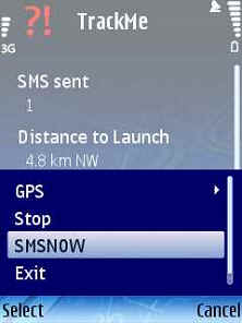
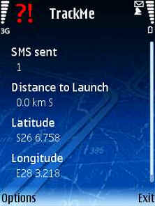
TrackMe (S60)-An application that sends your location at a regular interval via SMS to another cellphone. If it receives a SMS query in a certain format (e.g. from RTMS), will send your location to the predefined number.
Like it? Share with your friends!
If you got an error while installing Themes, Software or Games, please, read FAQ.
FON Access Points for USA FON Access Points for USA - FON offers you a new Points of Interest service (POIs). This allows you to download FONspots directly to your navigation device.
What does that mean? You can download a Points of Interest file directly to your navigation device
Foreca weather Foreca weather- provides current conditions, 10 day weather forecasts and various weather animations for any location world-wide.
You can choose from over 140.000 hand picked locations or you can retrieve forecasts for your current location using your phone's GPS. You can also use the Landmarks in your phone or you can enter a new location by coordinates
Easy Locator Free Easy Locator Free - Have you wondered if you forgot your phone at work or if you dropped it at the gym? Would you like to be able to locate somebody else without having to call them? All you need to do is install Easy Locator on the phone you would like to follow from a distance – whether your own, that of your child, your assistant or a friend
Aspicore GSM Tracker 3 Aspicore GSM Tracker 3 - Purpose
The product is intended for fleet tracking, field force automation or personal location tracking.
Would you like to..
GPS Action GPS-Action software sets automatic alarms and performs different actions according to the GPS and Ce
FON Access Points for Mexico FON Access Points for Mexico - FON offers you a new Points of Interest service (POIs). This allows you to download FONspots directly to your navigation device.
What does that mean? You can download a Points of Interest file directly to your navigation device
FON Access Points for Lebanon FON Access Points for Lebanon - FON offers you a new Points of Interest service (POIs). This allows you to download FONspots directly to your navigation device.
What does that mean? You can download a Points of Interest file directly to your navigation device
FON Access Points for Ethiopia FON Access Points for Ethiopia - FON offers you a new Points of Interest service (POIs). This allows you to download FONspots directly to your navigation device.
What does that mean? You can download a Points of Interest file directly to your navigation device
FON Access Points for Cambodia FON Access Points for Cambodia - FON offers you a new Points of Interest service (POIs). This allows you to download FONspots directly to your navigation device.
What does that mean? You can download a Points of Interest file directly to your navigation device
FON Access Points for Israel FON Access Points for Israel - FON offers you a new Points of Interest service (POIs). This allows you to download FONspots directly to your navigation device.
What does that mean? You can download a Points of Interest file directly to your navigation device
Other Software by developer «Ulf Arndt»:
Pilot Recovery System Pilot Recovery System - A simple J2ME JAVA Midlet that can be used with the Pilot Recovery System. Can be used for the Winelands Paragliding comp. The JAVA J2ME Midlet feeds via SMS the Pilot Recovery status webpage
PRS GPS PRS GPS - Uses a built-in GPS of a Nokia Phone and JAVA J2ME based Location based service to SMS your Pilot Status to the Pilot Recovery System. Can be used for the Winelands Paragliding comp. The JAVA J2ME Midlet feeds via SMS the Pilot Recovery status webpage
RTMS RTMS - This JAVA Midlet sends a SMS to a mobile phone that runs the TrackMe code.
It sends an SMS to TrackMe, TrackMe then sends a SMS with the location data to the predefined number.
The predefined number gets set by the enduser when TrackMe gets started.
The code needs a trackmesms.txt file in the Images folder of the cellphone
TrackMeTweet TrackMeTweet - uses the built-in GPS, or a Bluetooth GPS (recommended for cellphone battery life) to send regular tweets of your location to Twitter.
The Tweet info contains your identifier, distance from take-off in km, coordinates in degrees and decimal minutes, altitude in meters above sea level, speed in km/h, direction you are heading at that specific moment

")
")
")